
OBSERVER: The 10th edition of the Copernicus Ocean State Report reveals an ocean transforming under climate change
This year’s edition of the Copernicus Ocean State Report 10 (OSR10) highlights how ocean warming and extreme climate events are transforming the ocean at every scale, from affected microscopic life to major circulation systems, with far-reaching impacts on marine ecosystems and coastal communities. From European seas under pressure, to ice loss in polar regions, to the overlapping threats to Small Island Developing States, ocean changes and the challenges they generate are a present-day reality. The OSR10 and its accompanying interactive summary also explore how ocean science has advanced significantly over the past decade, and how this knowledge can inform and support timely action. In this Observer we look at the report’s key findings and how ocean knowledge can help society prepare for change.
The Copernicus Ocean State Report (OSR) is produced annually by the Copernicus Marine Service, which is implemented by Mercator Ocean International, along with an interactive summary for policymakers, blue economy stakeholders, and the public which highlights the use of ocean knowledge in helping society prepare for the future. Over the past ten years, the Copernicus Ocean State Report has documented the changing ocean, providing an authoritative scientific record which supports research, policy, and society. This achievement belongs to the scientific community, the network of Copernicus Ocean State Report authors across Europe and beyond, whose dedication, curiosity, and collaboration have made it possible.
Ocean warming and ecosystem change
This year’s report reveals transformations in the ocean placing increasing pressures on marine life and coastal communities from the tropics to polar regions.
The amount of heat stored in the ocean has been increasing at an accelerating rate since 1960 and reached its highest level on record in 2025. Ocean warming is a major climate change stressor to marine ecosystems, adding to others such as changes in salinity, deoxygenation, and acidification. An analysis of sea surface salinity in OSR10 reveals how most higher salinity regions, including the North and South Atlantic, tropical Pacific, and waters west of Australia, grew saltier between 2011 and 2024. Meanwhile, most fresher regions, such as the North Pacific, the eastern Indian Ocean, and parts of the Congo and Amazon River plumes, grew fresher. The global ocean also grew roughly 17 % more acidic from 1985 to 2025. Around 25 % of the top 1,000 m of the ocean is now impacted by over two climate change stressors simultaneously, with far-reaching impacts across marine ecosystems and human society.
Some of these impacts were reflected in a study analysing the seasonal growth patterns of microscopic organisms called phytoplankton. Using data from 1998 to 2024, the study found that around 5 % of the global ocean has seen a persistent shift in these patterns, pointing to ongoing reorganisation of marine ecosystems around the world.
Marine heatwaves and storms in European seas
European seas are undergoing significant warming and being affected by more frequent marine heatwaves and severe storms. In 2024, parts of the Mediterranean and Black Seas were affected by marine heatwaves which broke records in both intensity and duration. Some heatwave events lasted for over 30 days, with temperatures exceeding 4.6 °C above the average in certain regions. The highest number of marine heatwave days in the Mediterranean Sea in a single year over the past two decades was recorded in 2024, with average sea surface temperatures reaching 1.23 °C above the 1982-2024 baseline.
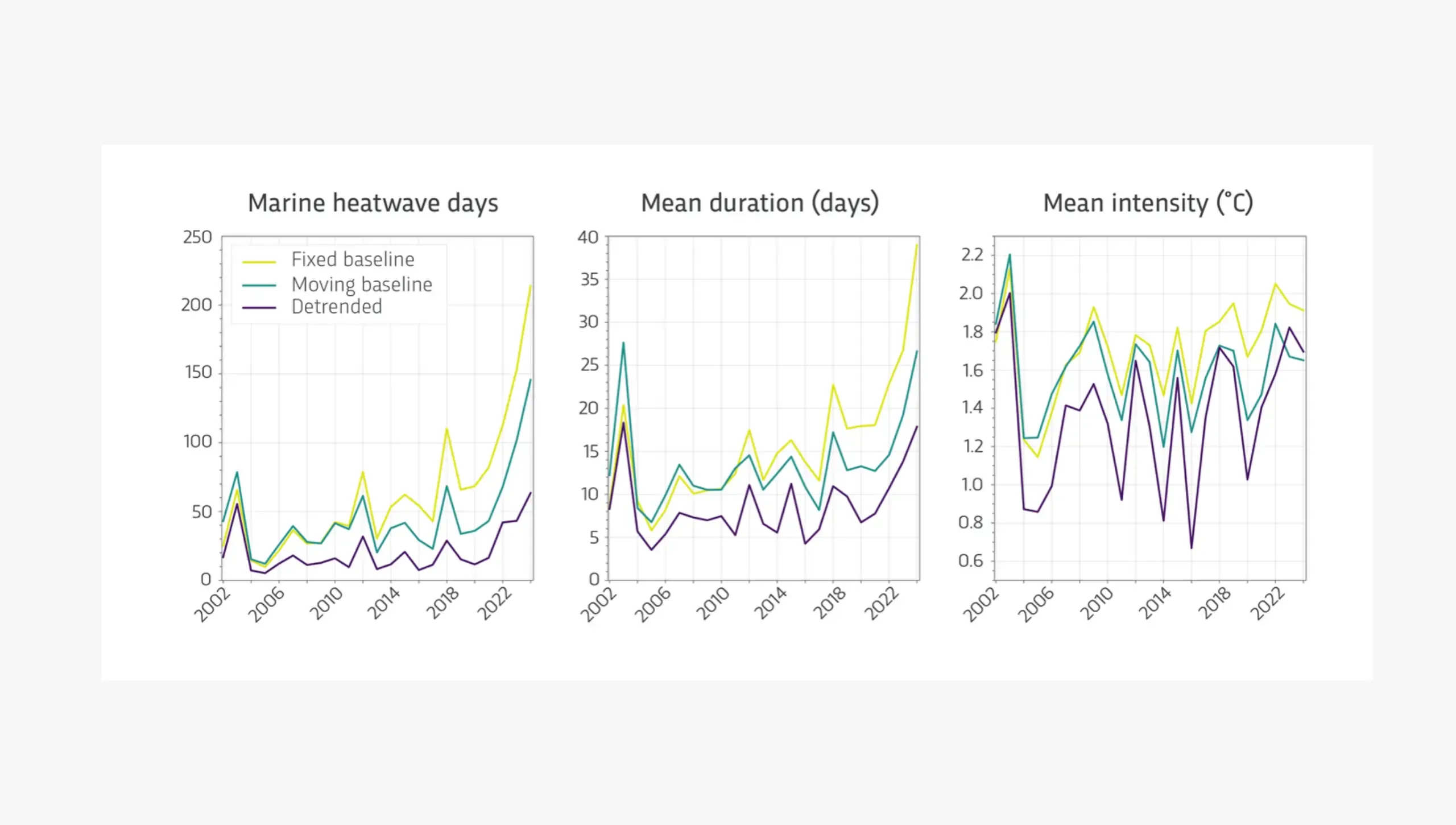
Storms across the region caused significant disruption. In February 2024, Storm Louis severely affected transport networks, caused widespread power outages, and one fatality, hindering maritime operations at two Spanish harbours, Langosteira in the northwestern Iberian (NWI) region and Tarragona in the northeastern Iberian (NEI) region. Unusually strong winds drove highly energetic waves more than 8 m high, though wave conditions within the two ports differed significantly due to their mouth orientation and infrastructure configuration. Heavy storms led to several exceptional marine events in the Adriatic Sea between 2023 and 2024, including drops in water salinity, widespread flooding, and eutrophication. Eutrophication occurs when excess nutrients in marine or freshwater systems promote excessive growth in populations of phytoplankton and other algae. This excessive growth can alter ecosystem equilibria.
Changes in polar regions
In polar regions, ice melt is generating new impacts for coastal communities and regional biodiversity. In the Arctic, sea surface and sea-ice surface temperature has risen roughly 4.2 °C over the last four decades, while monthly average sea ice extent fell roughly 490,000 km² per decade between 1979-2025. This loss leads to more wind and waves, putting coastal infrastructure at risk from erosion: around 60 % of Arctic coastal infrastructure have become vulnerable to erosion and sea-level rise.
All Arctic polar regions with seasonal sea-ice cover saw sea-ice decline between 1982 and 2024. The largest loss was recorded in the Barents Sea, at 70 % compared to the 1993–2010 baseline. An ongoing ‘Atlantification’ process began here around the turn of the 20th century, as warmer, saltier waters entering from the Atlantic changed salinity levels and affected the regional climate. Yet due to an unprecedented influx of fresher water from the North Atlantic, this paused between 2016 and 2022. Changes in salinity, and therefore density, of water in the Barents Sea matter as it feeds into the deep branch of the Atlantic Meridional Overturning Circulation (AMOC), a major component of the ocean circulation system.
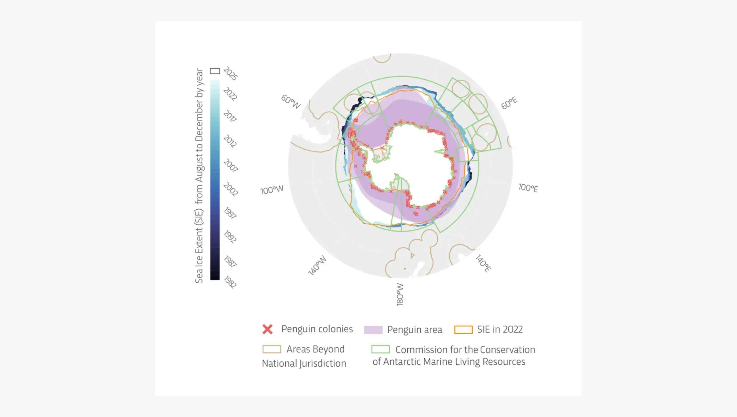
In the Antarctic, record-low sea ice extent in 2022 coincided with the first-ever recorded large-scale breeding failure of Emperor Penguins, showing how the habitat supporting Southern Ocean biodiversity is changing. Protecting biodiversity therefore requires both reducing local pressures through conservation and addressing the climate drivers of sea-ice loss through global mitigation.
Pressures on small island developing states
The report also draws attention to Small Island Developing States (SIDS), a group of nations with an important role in marine biodiversity conservation which are facing rising and compounding threats from climate change.
SIDS have jurisdiction over vast ocean areas, and their exclusive economic zones (EEZs) are home to some of the world's richest marine ecosystems, giving them a vital stewardship role for global ocean biodiversity. Nearly 28 % of the combined area of SIDS EEZs contains vulnerable, endangered, or critically endangered coral reefs, with great ecological and economic value. Coral reefs can account for over 20 % of GDP in some SIDS.
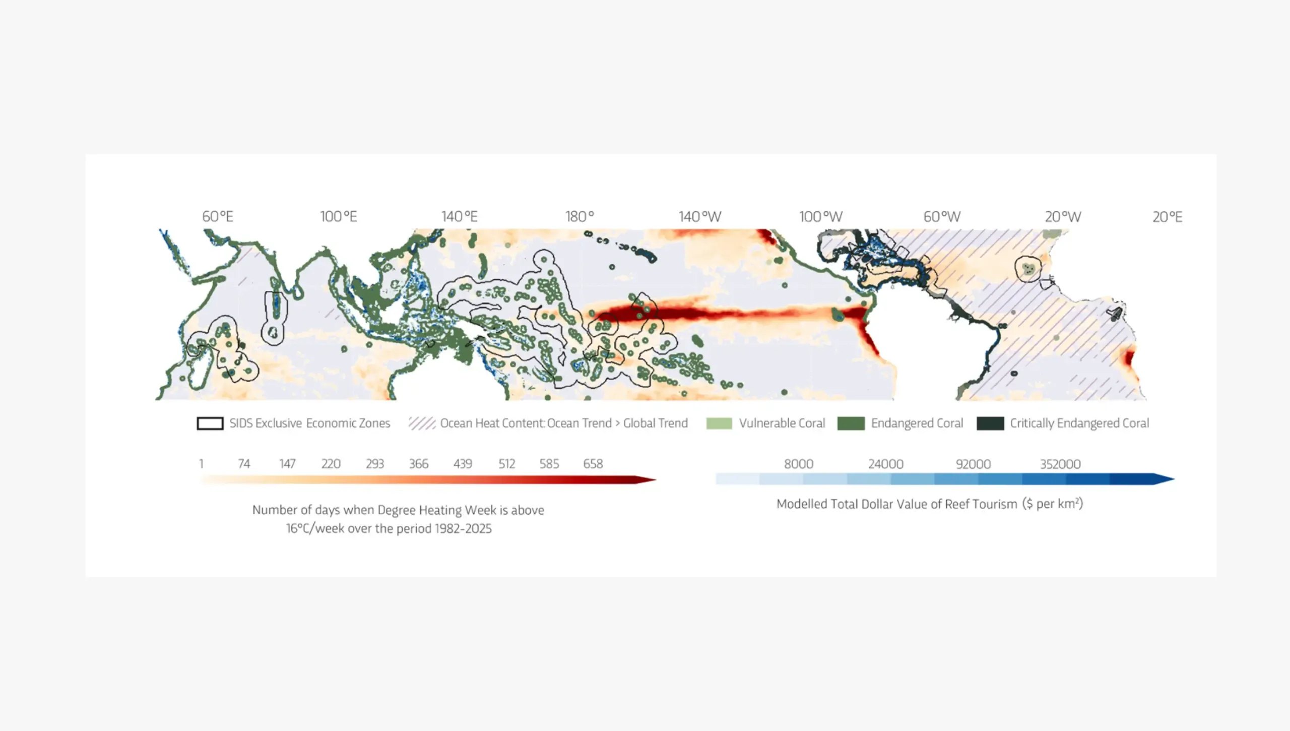
However, since 1960, all SIDS EEZs have been affected by ocean warming and nearly a quarter of threatened coral reefs in SIDS EEZs accumulated at least one month of mortality-level heat stress between 1982 and 2025. Tropical cyclone heat potential (the ocean heat available to support cyclone intensification) also rose at rates above the global average in more than half of SIDS between 1960 and 2025. This rising heat can intensify cyclones and lead to more storm surges, destructive extreme sea level events.
The report also highlights how biodiversity in SIDS provides valuable coastal protection, with coral reefs and mangroves reducing wave energy and protecting tourism and other coastal infrastructure from erosion and storm damage. In 18 SIDS, the annual expected benefit of mangrove coastal protection exceeds USD 1 million.
How ocean knowledge becomes action
As this 10th edition of the OSR and summary show, data, science, and ocean knowledge can not only help us better understand what exactly is happening in the ocean and why, but also assist us in anticipating future threats, building climate-resilient infrastructure, and making informed decisions for sustainable ocean stewardship. Several examples in monitoring and forecasting illustrate how.
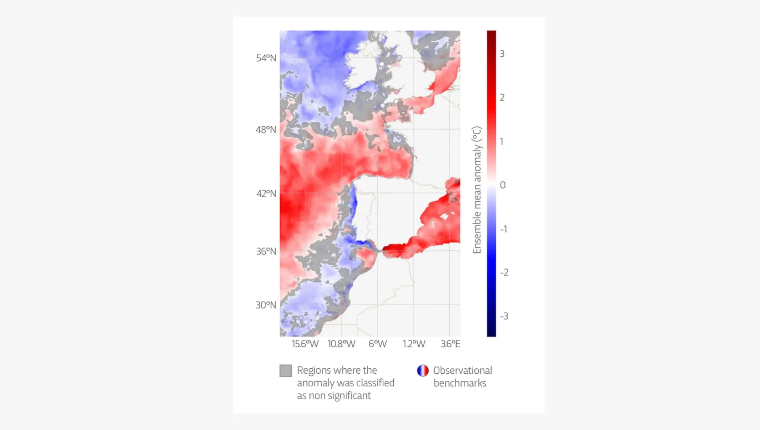
Researchers developed an innovative approach to characterise marine heatwaves in the Mediterranean and Black Seas, combining data on surface temperature and ocean heat content down to 40 m. This revealed seasonal complexity across the two seas and key differences emerged, including cases where surface anomalies were not accompanied by subsurface warming, and vice versa. An indicator which tracks extreme sea surface temperature events around the Iberian Peninsula, the Bay of Biscay, and Ireland (IBI) has also been refined, improving our ability to monitor extreme ocean conditions such as heatwaves.
In November 2024, an intense storm over the Baltic Sea led to a record 153 cm drop in sea levels in the Bothnian Bay, 34 cm lower than the previous record set just two years earlier in 2022. Due to low sea levels, local ferry operations were suspended for 18 hours. This was only the third such suspension caused by low sea levels in 56 years. Scientists used tide gauge, wind, and Copernicus ERA5 reanalysis data to investigate the accuracy of the Copernicus Marine Service Baltic forecasting system in predicting the storm and its impacts on sea levels. Forecasts predicted lower sea levels leading up to the event and showed high accuracy up to 3–4 days beforehand. Forecasting such extreme sea level events can help with coastal and maritime planning.
The Copernicus Ocean State Report 10
The Copernicus Ocean State Report 10 was published in the ‘State of the Planet’ journal on 30 September 2026. It draws on a broad range of knowledge and expertise, with contributions from over 65 scientific experts across Europe and around the world. The interactive summary is also available for policymakers, blue economy stakeholders, and the public. Mercator Ocean International, a world-leading organisation in digital oceanography and ocean prediction, has implemented the Copernicus Marine Service since 2014. It is now evolving into an intergovernmental organisation, further strengthening its collaboration with European and global partners to advance digital ocean systems and services for a sustainable ocean.