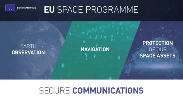
European Union flag
EU Space Policy

Explore EU Space

Results (276)
News
A visual banner for the EU Space Days 2026 in Nicosia, Cyprus. The banner includes a satellite image of Cyprus, the text 'EU Space Days 2026' as well as the logos of the European Commission and the Cyprus Presidency of the Council of the European Union.
Space Technologies
Space is increasingly central to the EU's security, resilience, and economic future. Against that backdrop, EU Space Days 2026 brought together senior EU decision-makers, industry leaders, start-ups, and researchers in Nicosia, Cyprus, for two days of high-level discussions on the state and direction of Europe's space endeavours.
News
A mosaic map of the European Union created from Copernicus Sentinel satellite imagery, overlaid with the 12 gold stars of the EU flag, produced to mark Europe Day 2026
Earth Observation | Copernicus
Satellite Navigation | Galileo & EGNOS
Secure Communication | IRIS² & GOVSATCOM
Space safety | Space Situational Awareness
Space safety | Space traffic management
The EU space policy and programmes support a wide range of services used across Europe every day. In this Observer, we explore how the EU space policy and programmes support people, public authorities, businesses, and critical infrastructure across Europe.
News
Infographic from the European State of the Climate Report 2025, titled 'Temperature across Europe's land and seas'. The graphic presents four key findings: nearly all of Europe (at least 95%) recorded above-average annual surface air temperatures in 2025; 2025 was Europe's second most severe heatwave year on record; annual sea surface temperature for the European ocean region reached its highest level on record; and 86% of the European ocean region faced at least strong marine heatwave conditions.
Earth Observation | Copernicus
Europe faced another year of exceptional climate extremes in 2025, with almost the entire continent recording above-average annual temperatures. The European State of the Climate (ESOTC) 2025 report, produced by Copernicus C3S and the World Meteorological Organization (WMO), highlights a continent undergoing rapid change.
News
OBSERVER: 2,000 images and counting. Six years of Copernicus Image of the Day
Earth Observation | Copernicus
Since its launch on 2 April 2020, the Copernicus Image of the Day (IOTD) has published, 365 days a year, a daily image based on Copernicus data, highlighting significant environmental, meteorological, climate- or disaster-related phenomena, and the shifting state of our planet's land, sea, and atmosphere. Over six years, the series has reached...
News
OBSERVER: A quantum secure future with IRIS²
Earth Observation | Copernicus
As cyber threats evolve and quantum computing advances towards practical applications, traditional encryption methods face more complex challenges. The Infrastructure for Resilience, Interconnectivity and Security by Satellite (IRIS²) constellation represents Europe's ambitious response to this emerging reality, positioning the European Union...
News
OBSERVER: Five Copernicus apps transforming climate and atmosphere insights
Earth Observation | Copernicus
From assessing heat and cold stress to exploring historical climate data and future projections or mapping methane plumes and monitoring major aerosol events, a range of user-friendly digital tools from Copernicus is delivering climate and air-quality intelligence to users worldwide. Building on data from the Copernicus Climate Change Service...
News
OBSERVER: Record-breaking 2025 fire season in the EU — insights from the Copernicus Emergency Management Service
Earth Observation | Copernicus
The European Commission has adopted a new Communication calling for a more integrated EU-wide approach to wildfire risk management, covering prevention, preparedness, response, and recovery. The strategy comes as the newly published Advance report on Forest Fires in Europe, Middle East and North Africa 2025 from the Copernicus Emergency...
News
OBSERVER: Understanding the role of CLMS in carbon removal monitoring
Earth Observation | Copernicus
The EU's commitment to climate neutrality by 2050, set out in the European Climate Law, has made the accurate monitoring and verification of carbon removal a scientific and political priority. The Copernicus Land Monitoring Service (CLMS) provides harmonised land cover datasets and products which support more detailed and geographically...
News
OBSERVER: Understanding space weather events
Earth Observation | Copernicus
Our planet and the space environment surrounding the Earth are regularly affected by variations in solar activity. Though invisible to most of us, these fluctuations trigger space weather events, which can disrupt the operations of electronic equipment and affect critical infrastructure we rely on every day, from communication and navigation to...
News
OBSERVER: How Copernicus supports cultural heritage monitoring and preservation worldwide
Earth Observation | Copernicus
Across Europe and around the world, cultural and natural heritage sites face rising pressures from environmental change, urban development, natural hazards, illegal activities, and conflict. Satellite-based observations provide consistent, long-term information which helps authorities, researchers, and site managers understand how these sites...
News
OBSERVER: How the EU Space Programme is helping shape aviation's future
Earth Observation | Copernicus
Through its advanced satellite technologies and space-based systems, the EU Space Programme is transforming how aircraft navigate, communicate, and operate across European airspace and beyond. Innovations from EGNOS, Galileo, Copernicus, and soon IRIS², are changing the way we fly. Precision landing and navigation systems developed under the EU...
News
OBSERVER: CLMS Snapshots – a new era in environmental storytelling
Earth Observation | Copernicus
The Copernicus Land Monitoring Service is expanding its reach through its CLMS Snapshots, a new tool which uses interactive, visually rich story maps to bring land monitoring insights to wider audiences. These story maps translate complex environmental data into accessible narratives for journalists, educators, environmental communicators, and...
News
OBSERVER: What is IRIS²?
Earth Observation | Copernicus
A new era for European space connectivity is unfolding. With IRIS², the European Union is building a sovereign satellite constellation that will secure communications, protect critical infrastructure, and expand secure connectivity to citizens, including in underserved areas. In this Observer, we explore what IRIS² is, how it builds on the...
News
OBSERVER: From space to civil protection - How SUNSHINE supports disaster resilience in Europe
Earth Observation | Copernicus
Europe’s risk landscape is changing rapidly, with climate-driven hazards and complex crises placing increasing demands on civil protection authorities. As disasters become more frequent, intense and cross-border by nature, the ability to anticipate events, efficiently prepare, respond rapidly, and coordinate across systems and institutions...
News
OBSERVER: How the EU Space Programme supports agriculture
Earth Observation | Copernicus
The global population has quadrupled in just a century, reaching eight billion in 2022. A growing population means rising demand for food, making sustainable agriculture more critical and necessary than ever. Yet, modern farming faces mounting challenges, including soil degradation linked to pesticide use and plastic pollution, as well as more...

Showing 1-20 of 276 results