
OBSERVER: Looking at the Earth after dark – How GHSL and SDGSAT-1 data turn nighttime lights into better decisions
At night, seen from space, our planet redraws itself. Coastlines and terrain fade into darkness, and a web of light takes their place, ‘highlighting’ where people live and move. For decades, such views have fascinated the public and served science alike, but satellite sensors could only show city lights in large blocks, often hundreds of metres wide. Recently, the team behind the Global Human Settlement Layer (GHSL), the exposure mapping component of the Copernicus Emergency Management Service (CEMS), published the results of a study, releasing the first annual nighttime light composites built from SDGSAT-1 satellite data at 40-metre and 10-metre resolution, together with the open-source method used to produce them. In this Observer, we take a look at what these datasets are, how they were built, and why sharper views of Earth at night matter for disaster management, urban policy, and sustainable development.
Understanding the residential fabric matters because the human settlement footprint is changing rapidly. In less than 50 years, the global population has doubled from four billion in 1975 to eight billion in 2022, while the built-up surface of the planet has almost tripled. Satellites allow the monitoring of this transformation consistently across countries and over time.
Tracking this transformation is the mission of the CEMS’ Global Human Settlement Layer, which is implemented by the European Commission's Joint Research Centre (JRC). GHSL extracts information on built-up areas from Copernicus Sentinel-1 and Sentinel-2 satellite imagery and combines it with national census data, producing and releasing several free, full and open datasets, including: GHS-BUILT, which maps built-up surfaces; GHS-POP, which estimates population distribution; and GHS-SMOD, which classifies settlement types according to the Degree of Urbanisation (DEGURBA) methodology.
These datasets underpin several tools in international policy. The Degree of Urbanisation methodology, endorsed by the United Nations Statistical Commission in 2020, applies GHSL grids to classify cities, towns, and rural areas in a consistent way worldwide. GHSL data also feeds the monitoring of the Sustainable Development Goals (SDGs) and the Sendai Framework for Disaster Risk Reduction. The periodic Atlas of the Human Planet synthesises its findings on global urbanisation, as explored in a previous EU Space Observer article.
Yet all of these products share one structural characteristic: built from daytime observations, they map the physical footprint of settlements, the roofs, roads, and buildings visible under the sun. What they cannot show is how those same places look after dark: which areas are lit, how intensely, and how persistently. Nighttime light observation adds precisely this functional dimension to the picture.
An improved view of Earth at night
Scientists and policymakers have used nighttime light data for decades. Researchers use it as a proxy for economic activity, to track rural electrification, to assess the magnitude of power outages after disasters, and to monitor the expansion of settlements. Until recently, however, the field relied on previous-generation sensor technology. The most widely used source, the Day/Night Band of the NASA VIIRS instrument, tracks nighttime lights at roughly 750-metres resolution under ideal viewing conditions, a scale fine for global statistics but too coarse to distinguish a motorway junction from the neighbourhood beside it.
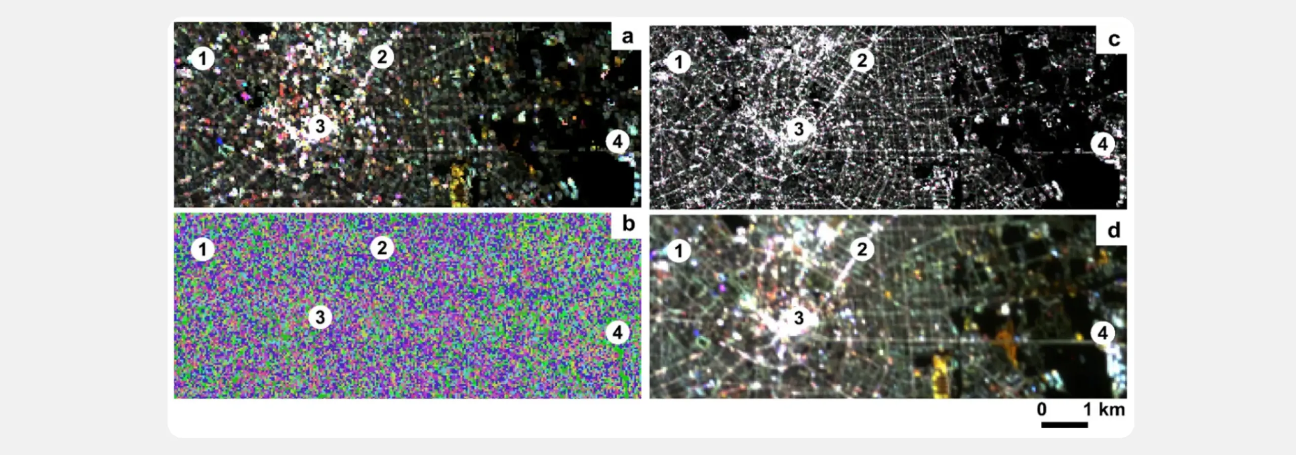
SDGSAT-1, launched in November 2021 and operated by the International Research Center of Big Data for Sustainable Development Goals (CBAS), changed this baseline. The satellite carries the Glimmer Imager for Urbanisation (GIU), a sensor specifically designed to observe artificial light at night. The GIU captures nighttime lights in three visible bands (red, green, and blue) at a 40-metre spatial resolution and in a panchromatic, or black-and-white, band at 10 metres. Features previously blurred into a single glow can now be seen in much finer detail.
However, a single night image can be misleading. Clouds, haze, snow reflecting moonlight, or sensor artefacts can all make places appear brighter than they really are. Until now, scientists were facing a key challenge: how to combine high-resolution night images into stable and comparable annual maps. Closing this methodological gap is what the GHSL team set out to do.
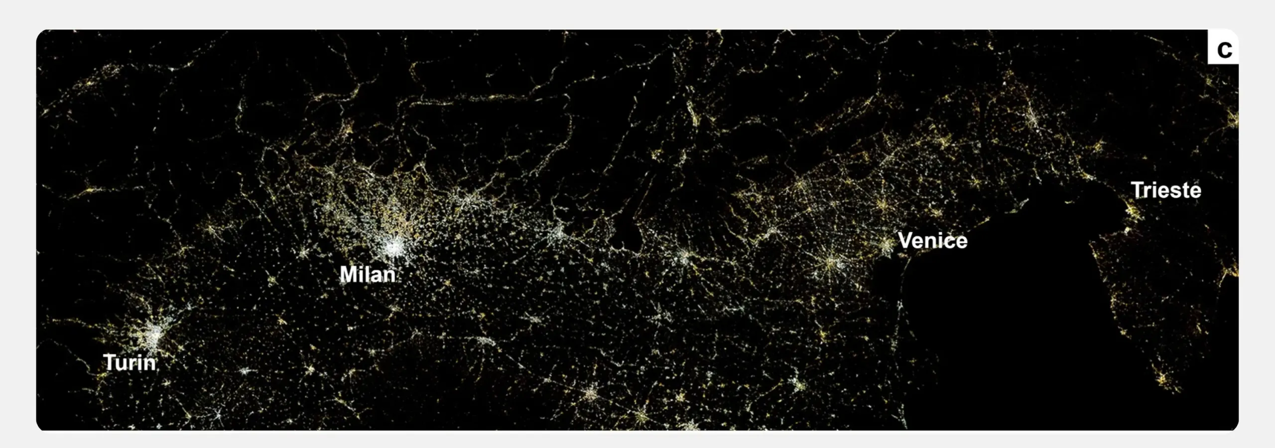
The approach was applied over a 120,000 square kilometre area of Northern Italy, stretching from the Alps to the Adriatic Sea, a test area selected for its diversity of landscapes and light sources. The results appeared in a study published in the journal Remote Sensing of Environment.
This scientific progress also reflects a wider international effort. The input data were provided by CBAS free of charge under the SDGSAT-1 Open Science Programme. The joint work is anchored in the Human Planet Initiative of the Group on Earth Observations (GEO), which the JRC co-chairs. The collaboration is built on open data, open methods, and results returned to the global community.
What are nighttime light composites and how are they created?
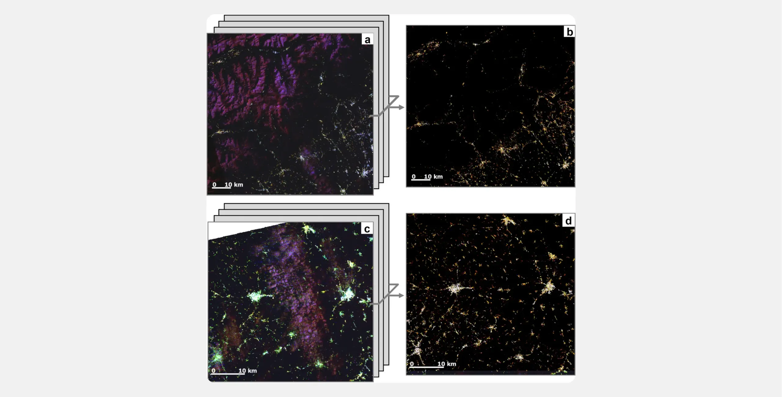
A composite is a map created from many satellite images. The common way to merge many nighttime images is to keep, for each location, the brightest observation recorded during the year. The brightest observation, however, is often the wrong one. Moonlight reflected by clouds or Alpine snow can outshine a town, so the brightest-pixel rule floods the map with false lights.
The GHSL team modified this logic with a method called MAXIFICO, short for maximisation of structural image features for image compositing. Instead of selecting the brightest pixel, MAXIFICO looks for the clearest structure in the image: sharp edges, visible patterns, and strong local contrast. In simple terms, it chooses the view where the ground is easiest to identify, rather than the one where the light is strongest. This simple principle helps remove misleading effects resulting from clouds, haze, and snow without any physical atmospheric model or external cloud mask.
The approach has an additional significant benefit: it is fully reproducible. The same input data always produces the same result, and each pixel can be traced back to the source image from which it came. In addition, consistent with the free, full, and open policy of Copernicus, the tools, data sources, and composites themselves are openly available to any user on the European Commission's code platform or from the GHSL data repository.
From night lights to actionable knowledge and decisions
For emergency management, stable annual nighttime light baselines address a long-standing operational need. When disaster strikes, comparing post-event images with a clean pre-event baseline can help responders detect power outages, assess damage to electrical infrastructure, and monitor recovery at a much finer scale than before. This builds on a capability already central to CEMS: GHSL population and built-up grids have supported assessments after major disasters, including the 2023 earthquakes in Türkiye, and the 2022 floods in Pakistan. High-resolution nighttime baselines can add a more dynamic layer, showing not only where people and assets are located, but also how human activity changes before, during, and after a crisis.
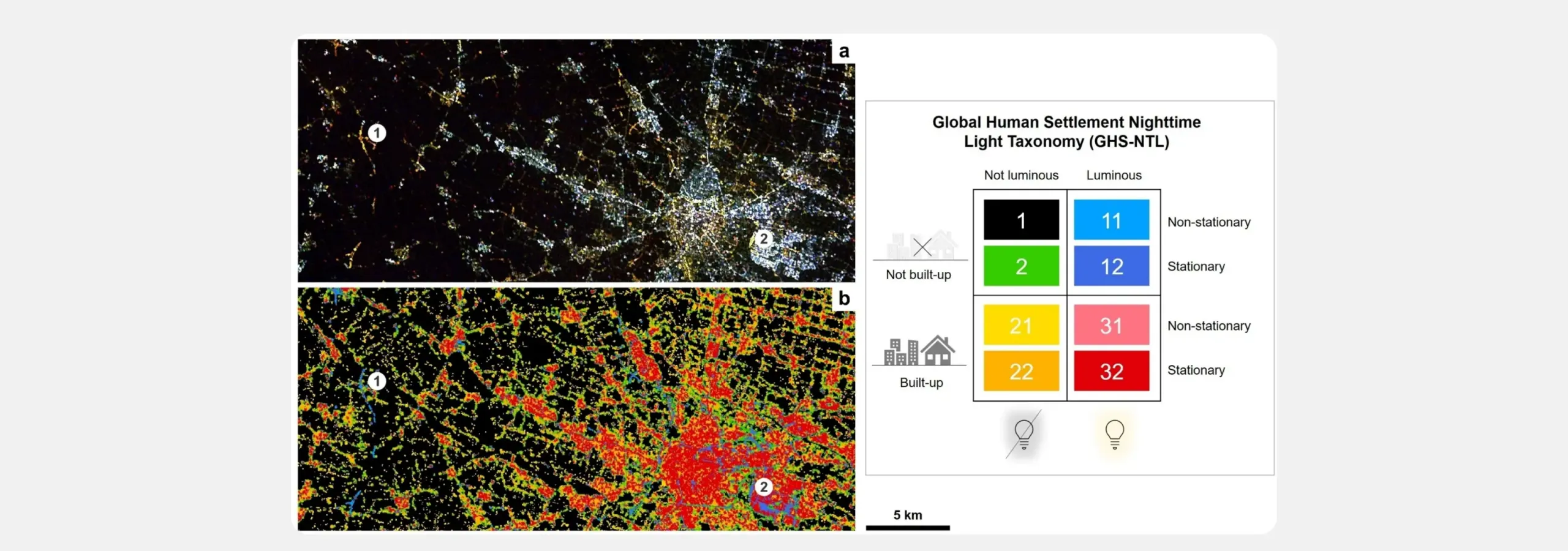
Beyond emergencies, the new composite products also open perspectives for urban policy, energy planning, and sustainable development. Nighttime light intensity remains one of the most practical proxies for tracking electrification and economic activity, especially in areas where ground statistics are not always available. Combined with the wider GHSL portfolio, these data can support comparison across locations, monitor progress, and support systems such as GDACS and the INFORM Risk Index, which inform humanitarian operations planning across European Union and United Nations agencies.
The method is not limited to SDGSAT-1 data. It could also be applied to data acquired under the first and second Sentinel-2 Nighttime Imaging Campaign. Interest in the field is growing more widely: ESA is organising the 2nd European Workshop on Artificial Nighttime Light Remote Sensing to be held at ESA-ESRIN in Frascati, Italy, from 12 to 15 October 2026.
Monitoring Earth at night with more frequent and accurate data can therefore support stronger baselines, more precise damage assessments, and clearer measures of recovery. This research presents both a product and a model: European scientific capacity, open international data, and a transparent method coming together to turn the lights of our planet into reliable evidence for policymakers, emergency responders, and researchers.