European Union flag
English
EU Space Policy

Explore EU Space

Results (1263)
Image of the day
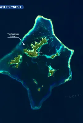
French Polynesia’s new protected marine area
Earth Observation
The Gambier Islands are a small group of volcanic islands and atolls in the south-eastern part of French Polynesia, in the South Pacific Ocean. Surrounded by a large lagoon and fringing coral reefs,…
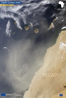
Image of the day
New Calima event in the Canary Islands, Spain
Earth Observation
A Calima event affecting the Canary Islands in September 2025 resulted in elevated temperatures, reduced air quality, and increased health risks on the archipelago. As a result, the Spanish State…
Image of the day
Severe flooding in Maradi, Niger
Earth Observation
Heavy rainfall in Niger from 9 to 15 September caused severe flooding in the area, resulting in casualties and widespread damage.   According to the United Nations Office for the Coordination of…
Image of the day
The Tihany Peninsula, Hungary
Earth Observation
Located on the northern shore of Lake Balaton, the Tihany Peninsula is one of the most iconic natural and cultural landmarks in Hungary. Protected as part of the Balaton Uplands National Park, it is…
Image of the day
Typhoon Ragasa strikes the Philippines
Earth Observation
Typhoon Ragasa, with wind gusts reaching 270 km/h, made landfall on Panuitan Island in the Philippines on 22 September 2025. Thousands of residents were evacuated as authorities issued alerts for…
Image of the day
Rotterdam, home to Europe’s largest maritime port
Earth Observation
Rotterdam is a key maritime gateway to Europe, home to the continent’s largest port and a crucial hub for international trade and logistics. This image, acquired on 19 May 2025 by one of the…
Image of the day
Absence of seasonal upwelling in the Gulf of Panama
Earth Observation
Each year, the Gulf of Panama undergoes a seasonal upwelling event, typically during the dry months from January to April. This process brings cold, nutrient-rich water from the deep ocean to the…
Image of the day
Cyclone Gabrielle
Earth Observation
Cyclone Gabrielle formed in the central Atlantic Ocean in mid-September 2025. By 22 September, it had rapidly intensified to the east-southeast of Bermuda, reaching Category 4 status with maximum…
Image of the day
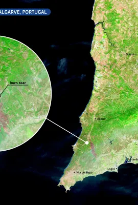
Wildfires in the Western Algarve, Portugal
Earth Observation
In mid-September 2025, a wildfire affected extensive areas of the Western Algarve, Portugal, particularly in the municipalities of Aljezur and Lagos. The fire, now under control, burnt large areas of…
Image of the day
Gries Glacier in Switzerland
Earth Observation
The Gries Glacier is a significant alpine glacier located in the Swiss Alps, in the canton of Valais. Recent field measurements indicate that the glacier is melting at an accelerated rate. Between…
Image of the day
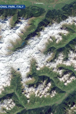
Snowfall in the Stelvio National Park, Italy
Earth Observation
The Stelvio National Park, located in northern Italy, is one of the largest protected areas in the Alps. Covering areas in the regions of South Tyrol, Trentino, and Lombardy, the park encompasses a…
Image of the day
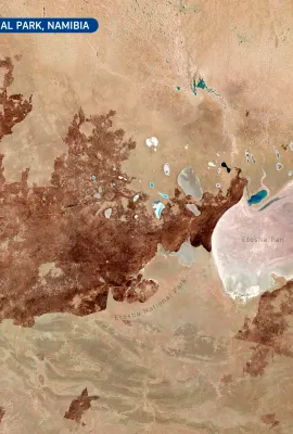
Fire in the Etosha National Park, Namibia
Earth Observation
Etosha National Park, located in northern Namibia, is one of southern Africa’s largest and most ecologically important protected areas.  A major wildfire recently affected the park, destroying…
Image of the day
Sydney, Australia
Earth Observation
Sydney, located on Australia’s south-eastern coast, is the country’s most populous city. It is built around a spectacular natural harbour, which has shaped its development and identity. The city is…
Image of the day
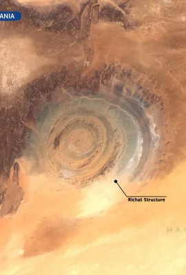
The Richat Structure, Mauritania
Earth Observation
The Richat Structure, a striking circular geological formation in the Sahara Desert of central Mauritania, is among the most distinctive landforms visible from space. Measuring around 40 kilometres…
Image of the day
The Neuquén and Agrio rivers in Patagonia, Argentina
Earth Observation
In the arid heart of northern Patagonia, the Neuquén and Agrio rivers flow through the dry landscape, forming narrow corridors of life in an otherwise inhospitable environment. These two rivers,…
Image of the day
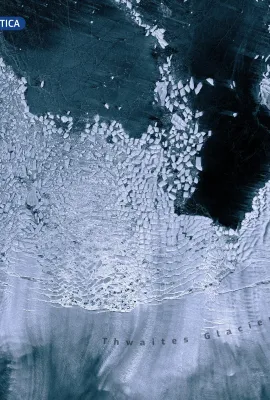
The Thwaites Glacier, Antarctica
Earth Observation
Spanning approximately 120 kilometres in width, Thwaites is one of the widest glaciers both in Antarctica and globally. The glacier flows into the Amundsen Sea and produces smaller calving events and…
Image of the day
Satellite image of Aalborg, Denmark, showing the city divided by a river with surrounding green farmland and rural areas.
Earth Observation
Aalborg, Denmark’s fourth-largest city, blends urban life with ecological awareness. Surrounded by a mosaic of agricultural land, parks, and bodies of water, the area supports diverse ecosystems…
Image of the day
Hurricane Priscilla hits Mexico
Earth Observation
Priscilla formed in early October 2025, becoming the fourth major hurricane of this Pacific season. It rapidly strengthened from a tropical depression to reach hurricane status within 48 hours. It…
Image of the day
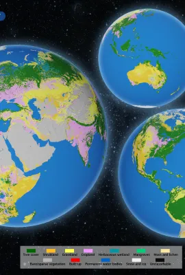
The CLMS Global Land Cover product
Earth Observation
This data visualisation is based on the Global Land Cover product from the Copernicus Land Monitoring Service (CLMS), released in June 2025 as part of the new Land Cover and Forest Monitoring (LCFM)…

Showing 581-600 of 1263 results