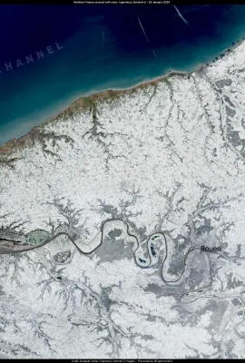
European Union flag
EU Space Policy

Explore EU Space

Results (558)
Image of the Day
Dust cloud stretching between the Canary Islands and Cabo Verde
Earth Observation | Copernicus
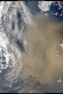
On 25 January 2024, one of the Copernicus Sentinel-3 satellites acquired this image, showing dust particles being carried by the wind from the Saharan desert over the ocean and extending to the Canary Islands and Cabo Verde. The sand is expected to reduce visibility and affect air quality in the affected areas, but will also contribute to the...
Image of the Day
The Sermeq Kujalleq glacier in Greenland
Earth Observation | Copernicus
The Sermeq Kujalleq glacier, is a prominent glacier located in western Greenland. Renowned for its dramatic ice flow and calving events, it is one of the fastest-moving glaciers in the world. It extends from the Greenland Ice Sheet to the Ilulissat Icefjord, a UNESCO World Heritage Site. Sermeq Kujalleq has attracted global attention because of...
Image of the Day
Storm Isha sweeps across the UK, leaving thousands without power
Earth Observation | Copernicus
Storm Isha made landfall in the UK on 21 January, bringing strong winds and heavy rain that left thousands without power overnight in Scotland, Wales, Northern Ireland, and north-west England.   This image of Storm Isha was acquired by one of the Copernicus Sentinel-3 satellites on 21 January. Thanks to the Copernicus' Sentinel satellites and...
Image of the Day
Belgium under snow
Earth Observation | Copernicus
The North of Europe has been affected by low temperatures and snow covered many European capitals. On 20 January 2024 one of the Copernicus Sentinel-2 satellites acquired this image of the city of Brussels under a white robe of snow. The Copernicus Land Monitoring Service product portfolio includes Snow & Ice (HR-S&I) Monitoring products, which...
Image of the Day
Netherlands and Belgium blanketed in white
Earth Observation | Copernicus
Cold temperatures caused snowfalls which affected many areas of the northern hemisphere over the past week. Many countries are currently blanketed, with snow with accumulations of up to 15 cm in some areas of northern Europe. The snow has caused traffic disruptions in several regions. This image acquired by one of the Copernicus Sentinel-3...
Image of the Day
Northern France covered with snow
Earth Observation | Copernicus
On 17 January, a snowstorm hit northern and central France, prompting the authorities to issue an orange alert in 21 departments and a yellow alert in many other affected areas. The storm had a major impact on transport, causing widespread traffic jams over hundreds of kilometres of roads and motorways. This image acquired by one of the...
Image of the Day
Heavy snowfall disrupts travel in part of Europe
Earth Observation | Copernicus
Large parts of central and northern Europe are under snow and below-average temperatures. On 17 January, the Oslo airport had to cancel flights, and train services were suspended in parts of Norway due to the heavy snowfall. There were also many snow-related transportation issues in Central Europe. In Belgium, trains were cancelled, and a red...
Image of the Day
Cyclone Belal hits La Reunion and Mauritius
Earth Observation | Copernicus
On 15 January 2024, Cyclone Belal hit Mauritius and the French island of La Réunion, bringing torrential rain and strong winds to the region. At least one casualty has been reported in La Réunion, where a level three cyclone warning has been issued, and a quarter of the population has been left without electricity and drinking water.  This...
Image of the Day
Iceland volcano
Earth Observation | Copernicus
Iceland is one of the world's most active volcanic regions. On 14 January, an eruption occurred on the Reykjanes peninsula near the town of Grindavik, which had been evacuated earlier due to increased seismic activity and the threat of a volcanic eruption. This image acquired by one of the Copernicus Sentinel-3 satellites at 13:10 UTC, a couple...
Image of the Day
Seoul
Earth Observation | Copernicus
The Seoul (Korea) metropolitan area, visible in this image acquired by one of the Copernicus Sentinel-2 satellites on 3 December 2023, is home to 26 million people.  A recent report by the United Nations Environment Programme (UNEP) on air quality in the metropolis has revealed that, in 2005, the levels of harmful air pollutants, such as...
Image of the Day
Santa Cruz del Islote
Earth Observation | Copernicus
The San Bernardo Archipelago, visible in this image acquired by one of the Copernicus Sentinel-2 satellites on 6 January 2024, is located in the Caribbean Sea off the northern coast of Colombia.  Consisting of 10 main islands, the archipelago is renowned for its pristine white sand beaches, crystal clear turquoise waters and rich marine...
Image of the Day
Monthly Antarctic Sea Ice in 2023
Earth Observation | Copernicus
The Copernicus Climate Change Service (C3S) has just released its annual climate summary for 2023.These data visualisations, based on CS3 and the EUMETSAT’s Ocean and Sea Ice Satellite Application Facility (OSISAF) data, illustrate the monthly sea ice extent around Antarctica in 2023. It reached an all-time minimum extent in February 2023 (33%...
Image of the Day
Monthly surface air temperature anomalies in 2023
Earth Observation | Copernicus
The Copernicus Climate Change Service (C3S) has just released its annual climate summary for 2023, which highlights high variability across Europe and extreme weather events. These data visualisations, based on CS3 data, illustrate the surface air temperature monthly anomalies for Europe in 2023, compared to the averages for the 1991-2020...
Image of the Day
The Bothnian Bay, frozen earlier than usual
Earth Observation | Copernicus
The formation of sea ice in the Baltic Sea has been favoured by the cold temperatures recorded in Scandinavia at the beginning of 2024. The ice cover is the most extensive since 2011 and about 4 times larger than usual at this time of the year, according to the Finnish Meteorological Institute. The entire Bothnian Bay is covered with sea ice,...
Image of the Day
Severe floods hit Northern France
Earth Observation | Copernicus
At the beginning of January 2024, heavy rainfall caused rivers to overflow and flood areas of northern France. This has affected around 1,300 homes, while almost 400 people have been evacuated. Several municipalities in the area have been impacted by power outages and water restrictions.  This image acquired on 5 January 2024 by one of the...
Image of the Day
Heavy floods in Germany
Earth Observation | Copernicus
Heavy floods are ongoing in Germany. Thousands of first responders are working tirelessly to tackle the aftermath of the heavy rainfall, which has particularly affected the northern states of Lower Saxony, Saxony-Anhalt, Saarland and North Rhine-Westphalia. The flooded areas in Lower Saxony are visible in this image acquired by the Copernicus...
Image of the Day
Anomalous towering waves hit California’s coast
Earth Observation | Copernicus
In late December 2023, a series of powerful storms in the Pacific Ocean caused massive waves, flooding and evacuation orders in coastal areas of Northern and Central California. The Ventura County coastline was hit hard when a rogue wave injured eight people. This image, acquired by a Copernicus Sentinel-2 satellite on 1 January 2024, shows the...
Image of the Day
Alvaro, the first cyclone of 2024
Earth Observation | Copernicus
The first cyclone of 2024, named Alvaro, made landfall near Morombe in Madagascar on 1 January, bringing strong winds and heavy rain. According to the latest forecasts from Meteo France, the storm is unlikely to pose a threat to other regions and is expected to gradually weaken. This image, acquired by one of Copernicus Sentinel-3 satellites on...
Image of the Day
El Hierro Island in the Canary Archipelago, a pioneer in renewable energies
Earth Observation | Copernicus
El Hierro, the smallest volcanic island in the Canary Archipelago, holds the distinction of being a UNESCO World Biosphere Reserve and Geopark. Notably, it recently achieved a significant milestone as the first island worldwide to sustainably operate for 28 consecutive days using exclusively wind and hydro power. This achievement was in part...
Image of the Day
Eruption on Iceland’s Reykjanes peninsula
Earth Observation | Copernicus
After several weeks of precursor signals, a volcanic eruption on the Reykjanes peninsula in Iceland began on the night of 18-19 November. The eruption occurred about 5km from Grindavik, a town whose inhabitants had been evacuated earlier in the year in preparation for this event.   This image acquired by the SLSTR sensor onboard one of the...

Showing 321-340 of 558 results