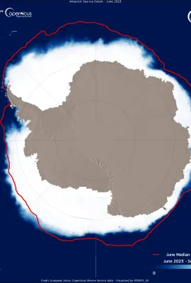
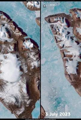
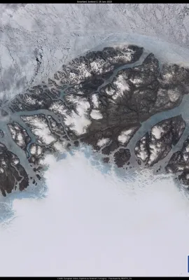
Greenland is grappling with a melting ice sheet episode, attributable to the persistent heatwave sweeping across the Arctic. Images from the Copernicus Sentinel-2 satellites, captured on 29 June and 3 July, show the changes in snow coverage on Nares Land, a northern Greenland island. The air temperature, about ten °C higher than the average...
Results (558)
This image, which visualises the Antarctic sea ice extent based on Copernicus Marine Service data, shows the negative Antarctic sea ice anomaly of June 2023, when the ice surface stood at circa 2.5 million km2 below the average area for the period. For several weeks in a row, the negative Antarctic sea ice anomaly increased, until it reached...
This image, acquired by one of the Copernicus Sentinel-3 satellites on 29 June 2023, shows melting ice trails in northern Greenland. A remarkable heatwave in Greenland is causing extensive melting conditions throughout the northern ice sheet. Climate change is having a profound impact on the Earth's polar regions, leading to a rapid rise in...
This image, acquired by one of the Copernicus Sentinel-2 satellites on 28 June 2023, shows the trail of destruction left by the wildfires in Quebec. The wildfire season in Canada has now become the worst on record. The fires have ravaged more than 8.1 million hectares of land across the country, surpassing the previous record set in 1989. As of...
This image, acquired by one of the Copernicus Sentinel-2 satellites on 27 June 2023, shows the island of Madeira. Part of a larger archipelago comprising four islands and designated as an autonomous Portuguese region, Madeira is located off the western Moroccan coast. The day this image was acquired was the hottest day in Madeira’s climatic...
This image, acquired by one of the Copernicus Sentinel-3 satellites on 28 June 2023, shows plumes of smoke from the Canadian wildfires reaching Sardegna after making their way across the Atlantic Ocean and over the Iberian Peninsula. The smoke has covered the central-northern part of the island after traveling thousands of kilometres and is now...
This image, acquired by one of Copernicus Sentinel-3 satellites on 22 June 2023, shows the massive smoke cloud produced by the multiple wildfires ongoing in Québec engulfing the sky of North America. Several communities in this Canadian province have been advised to prepare for evacuations, as the province’s forests Minister warned that...
This image, acquired by one of the Copernicus Sentinel-3 satellites on 20 June 2023, shows plumes of Saharan dust reaching Western Italy as the first summer heatwave hits the country. The dust will affect most of the peninsula, causing skies to appear yellowish or milky. The Copernicus Atmosphere Monitoring Service (CAMS) tracks all stages of...
This image, acquired by one of the Copernicus Sentinel-2 satellites, shows the Icelandic town of Egilsstaðir, where on 17 June 2023 temperatures reached 27.9°C. This exceptional value was the highest ever recorded in the country before the summer solstice. It is also noteworthy to mention that the Icelandic all-time record is 30.5°C. ...
This image, acquired by one of the Copernicus Sentinel-2 satellites on 6 June 2023, shows the coastal town of Point Lay in Alaska, USA. The permafrost on the Arctic coast of Alaska is thawing so fast that it is destroying buildings and infrastructure in Point Lay. The soil here is largely made up of a mixture of organic material, sediment, and...
This image, acquired by one of Copernicus’ Sentinel-3 satellites, shows plumes from the Québec wildfires making their way to north-eastern Europe. Canada, which is currently affected by around 450 active fires, has activated the EU Civil Protection Mechanism requesting European assistance. In an immediate response, France, Portugal and Spain...
This image, acquired by one of Copernicus’ Sentinel-3 satellites, shows Cyclone Biparjoy, which is expected to make landfall in India’s Gujarat state. As the cyclone gathers strength, emergency measures are being promptly implemented. In India, local authorities organised the evacuation of thousands of residents of the coastal areas deemed...
This image, retrieved from Copernicus Climate Change Service data, shows the surface air temperature anomaly for May 2023. It provides an indication of deviations from the long-term average temperatures for this period. The analysis reveals significant regional variations across different parts of the globe, reflecting the complex interplay of...
This image, acquired on 7 June 2023 by a Copernicus Sentinel-3 satellite, shows plumes from the Canadian fires reaching the American East Coast. In a region-spanning event, New York City found itself shrouded in thick smoke while Philadelphia and Washington DC declared a 'code red' emergency. New York City's iconic skyline became obscured,...
Extensive forest fires in Québec's North Shore region have caused the displacement of thousands of residents. The relentless fires, driven by dry weather conditions and strong winds, have posed a severe threat to numerous communities in the region. The displaced residents are grappling with the uncertainty over when they will be able to return...
Múlajökull is one of the glacial tongues that extends off the southeast portion of the of the Hofsjökull glacier system, the third largest in Iceland, located in the central highlands. Glacial tongues are long, narrow extensions of ice that flow down valleys or through mountain passes from larger ice caps or glaciers. The ice margin of the...
This image, acquired by one of the Copernicus Sentinel-3 satellites on 29 May, shows the wildfires which are devastating Nova Scotia and forced more than 16,000 Canadians to evacuate their homes. Emergency response teams are actively engaged in fighting the fires, but the scale and intensity of the infernos have made containment efforts...
Early signs of coral bleaching observed in Redang Island, Malaysia The consequences of record-breaking sea temperatures in recent months are becoming increasingly evident, particularly coral bleaching. The early signs of this phenomenon have been observed in Redang Island, Malaysia, which is visible in this image acquired by one of the...
The region of Emilia Romagna, in central Italy, is currently grappling with the aftermath of the devastating flood crisis of the past week. The situation remains challenging, with several landslides triggered by the intense rainfall and saturated soils severely affecting road traffic. These images, acquired by the Copernicus Sentinel-2...
Canada is currently experiencing an extremely severe fire season, which is having far-reaching consequences. The smoke plume generated by the fires has not only blanketed the skies over North America but has also begun to reach as far as northern Europe on 23 May. A notable instance occurred on 25 May, when one of the Copernicus Sentinel-3...
Showing 461-480 of 558 results