
OBSERVER: How Earth Observation supports mangrove monitoring in West Africa
West Africa's mangrove forests are among the planet's most productive ecosystems, but determining whether specific areas are in stable conditions, degrading, or recovering remains difficult. The extent and status of these coastal wetlands vary with tides, rainfall, salinity, and sediment conditions, while field surveys alone cannot capture change across such large and inaccessible areas. Earth Observation data support consistent monitoring over time and, when combined with field observations and local knowledge, can help distinguish mangrove loss from natural regeneration and assess the outcomes of restoration activities. In this Observer, we explore how Copernicus Sentinel satellite data, field knowledge, and African scientific expertise contribute to understanding and protecting West Africa's mangroves.
Mangrove forests occupy the transitional area between terrestrial and marine environments. Their extent and condition vary in response to tides, freshwater inputs, salinity, sediment transport, and human activity. These interacting processes have shaped West Africa’s mangrove forests for centuries, creating highly productive but environmentally sensitive ecosystems.
For Professor Cheikh Mbow, Director General of Senegal's Centre de Suivi Écologique (CSE), this position between terrestrial and marine environments explains why mangroves are sensitive to climate change.
‘Mangroves are the only dense forests capable of thriving in saltwater environments. They grow at the volatile intersection between strong tides and continental freshwater flows.’ Changes in rainfall, sea level, sediment transport, or human activity can influence the environmental conditions on which mangroves depend, affecting their distribution and condition.
Despite covering a small fraction of the Earth's surface, mangroves provide significant ecological and social benefits. They stabilise coastlines, reduce erosion, support fisheries, store large amounts of carbon, and sustain livelihoods developed over generations. For many coastal communities in West Africa, mangroves provide food and income, and reduce the impacts of floods and wave action. However, determining whether these forests are stable, degrading, or recovering remains complex.
Mangrove changes are not limited to forest loss
Senegal’s main mangrove ecosystems include those of the Saloum Delta and Casamance Estuary. These ecosystems have often been portrayed as being in widespread decline, but Professor Mbow describes the situation as being more nuanced.
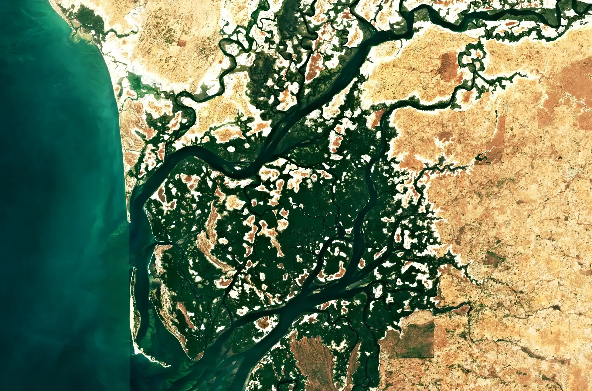
Earth Observation (EO) analyses and field studies suggest that neither the Saloum Delta nor the Casamance Estuary have undergone widespread, irreversible mangrove loss. Instead, many sites appear to be going through ecological transitions. Some areas remain stable, while others show natural regeneration or changes in species composition as environmental conditions evolve.
"People often focus on whether mangroves are disappearing, but what we are increasingly observing is that ecosystems are changing."
— Professor Cheikh Mbow
Director General, Centre de Suivi Écologique, Senegal
Mangrove forests are located at the interface between terrestrial and marine environments and are therefore affected by changes in both of these. On the riverine side, rainfall patterns influence how much freshwater reaches the coast. During drier periods, reduced river flow can increase salinity in estuaries. Infrastructure such as dams and water diversion schemes may also modify the conditions on which mangroves depend by changing river flow, while dams may trap sediment upstream and reduce the sediment supply to mangrove areas. On the marine side, changes in tidal flow can alter how often and how long mangrove areas are flooded and affect whether sediment is deposited or eroded. Coastal development may further alter local water flows and sediment movement. Together, the resulting changes in salinity, sediment supply, and flooding patterns help determine where mangroves of different species can take root and survive.
This complexity also challenges common assumptions about restoration. Across Africa, thousands of hectares of mangroves are replanted every year. Although these initiatives can contribute to restoration, Professor Mbow warns that planting alone should not be considered evidence of success.
Different mangrove species occupy highly specific ecological niches, meaning that they are adapted to particular salinity levels and patterns of tidal flooding. Mangroves planted under unsuitable tidal or salinity conditions may not survive. ‘The current momentum around blue carbon makes honest monitoring even more important,’ he says. ‘Earth Observation allows us to distinguish between successful restoration, natural regeneration, and unsuccessful interventions.’ Long-term EO records can show whether mangrove cover at a particular site declines, recovers, or persists. However, determining whether recovery results from restoration or natural regeneration requires EO data to be combined with records of where and when restoration activities were carried out, field observations, and local ecological knowledge.
Monitoring mangroves using satellite and field observations
Monitoring mangroves is difficult. Dense vegetation, tidal flooding, and difficult access can make regular field surveys expensive and time-consuming. Permanent monitoring plots remain indispensable, but they only cover limited areas.
Satellite observations have expanded the geographical and temporal reach of mangrove monitoring. According to Professor Mbow, the growing availability of freely accessible EO data, cloud computing, and open-source processing tools has modified environmental monitoring practices across Africa. Many satellite datasets are now available for wetland monitoring. Advances in artificial intelligence can also support the processing and analysis of wide-area observations.
A key advantage of EO is consistency. Satellite data allow mangroves to be observed repeatedly rather than assessed only during individual field campaigns. Long-term satellite records can reveal trends which individual field campaigns cannot capture. These records help distinguish seasonal variation from long-term ecological change, identify gradual shifts in vegetation cover, and support the assessment of restoration activities.
However, Professor Mbow cautions against relying exclusively on satellite products. He describes the volume and variety of available data as creating an ‘information overflow’, with datasets differing in spatial resolution, processing method, and update frequency. He therefore recommends combining satellite observations with regular field validation and local ecological knowledge.
Turning observations into action
The Copernicus Land Monitoring Service (CLMS) provides freely accessible information on land cover, vegetation dynamics, and forest change across several spatial and temporal scales. For coastal ecosystems such as mangroves, these datasets can support consistent annual monitoring across large areas.
Products within the Land Cover and Forest Monitoring (LCFM) product suite can support countries in assessing tree-cover change and evaluating the results of restoration programmes. They can also contribute to reporting progress towards international climate, biodiversity, and restoration commitments. The annual LCFM products provide a consistent and harmonised record of forest extent and land-cover dynamics. These records can help identify areas where mangrove cover has decreased, increased, or remained stable across large regions.
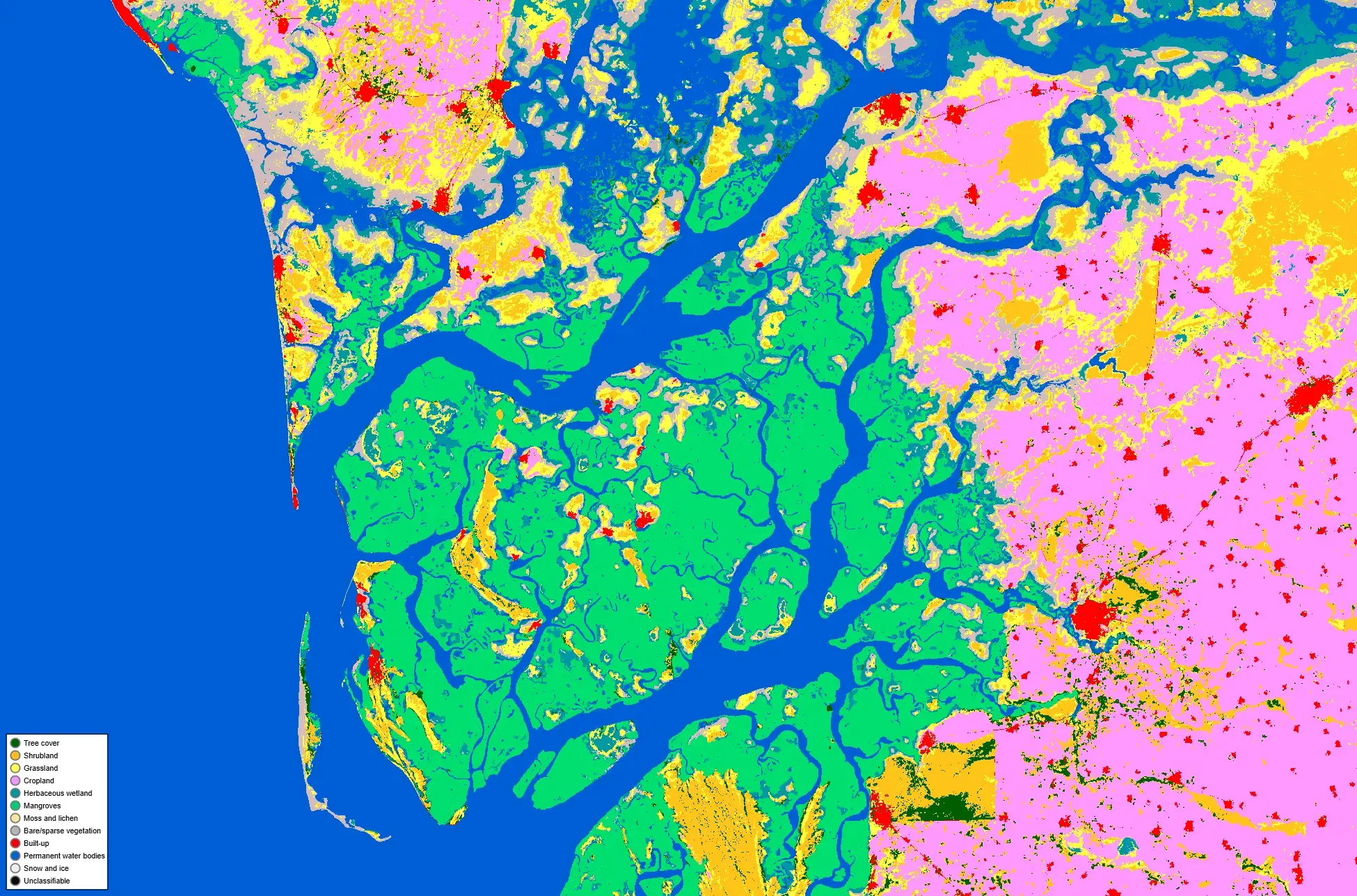
Beyond mapping mangrove distribution, CLMS products can provide information about vegetation structure and functioning. The CLMS Bio-geophysical Variables product suite provides an additional source of EO information.
Products such as the Leaf Area Index (LAI), Fraction of Absorbed Photosynthetically Active Radiation (FAPAR), and Fraction of Green Vegetation Cover (FCOVER) provide complementary vegetation measurements. These products deliver information about leaf area relative to ground area, the proportion of incoming photosynthetically active radiation absorbed by vegetation, and the proportion of the ground covered by green vegetation.
A practical example from Senegal
As part of the Sustainable Management of Wetlands for Strengthening Food Security and Resilience of Ecosystems in West Africa (GDZHAO) project, a consortium led by CSE developed an operational application for monitoring mangroves using Copernicus Sentinel-1 radar data and Sentinel-2 optical data.
The application produces annual mangrove maps at a spatial resolution of 10 metres. It monitors changes in forest extent and identifies areas classified as undergoing degradation or regeneration. The resulting information, which combines satellite observations with field validation, is made available through an online interface intended for protected-area managers, researchers, and public authorities.
The application shows how Copernicus data can support operational services for ecosystem restoration, coastal management, and adaptation to climate-related pressures in West Africa.
Looking ahead
As climate change continues to affect environmental conditions, EO tools will play an increasing role in monitoring changes in mangrove extent and condition.
Radar and lidar observations may improve scientists' ability to monitor biomass, vegetation structure, and changes in ecosystem conditions, while growing use of artificial intelligence and cloud processing may support the analysis of the resulting datasets. However, Professor Mbow believes that technology alone will not be sufficient.
Stronger regional cooperation, investment in African scientific capacity, and the integration of satellite observations with field knowledge can improve mangrove monitoring and inform protection measures.