OBSERVER: Mapping our changing planet – high-resolution insights with Copernicus LCFM
Understanding how the Earth's surface changes is key to addressing some of today's most pressing environmental challenges, from deforestation and biodiversity loss to land degradation and the consequences of climate change. Reliable, detailed land cover data gives scientists, governments, and policymakers the tools to track these shifts and design effective responses. To support these efforts, the Copernicus Land Monitoring Service (CLMS) has launched the Copernicus Global Land Cover and Tropical Forest Mapping and Monitoring (LCFM) product suite, which delivers global land cover and tropical forest monitoring products at 10-metre resolution. First released in June 2025, LCFM introduces a new level of global land spatial detail. In this Observer, we explore the first products released, their applications across diverse landscapes, the technology which underpins them, and plans for the years ahead.
A new level of detail for global land monitoring
Building on earlier initiatives such as Copernicus Global Land Cover, ESA WorldCover, and REDDCopernicus, the LCFM product suite represents a significant step forward in the monitoring of land surfaces at global scale. With a spatial resolution of 10 metres, the products allow users to observe land cover patterns at a level of detail which makes plot-level monitoring possible anywhere on Earth, making them particularly valuable for tracking deforestation, monitoring ecosystems, and understanding land-use change.
With an annual update frequency, the datasets enable the consistent tracking of environmental changes over time. They will extend the Copernicus land cover time series with yearly updates from 2020 to 2026, creating a long-term foundation for global land monitoring.
Future products will also introduce sub-annual land cover map layers, allowing users to observe seasonal dynamics and detect rapid land surface changes, and enabling near-real-time tracking of extreme events or land conversion.
First products now available
The Global Land Cover Map (LCM-10)
This dataset provides an annual global land cover map at 10-metre resolution, covering the entire planet. The land cover is characterised across 11 thematic classes, identifying major vegetation types, cropland, built-up areas, bare surfaces, water bodies, and snow and ice. With yearly updates, the LCM-10 product supports a wide range of applications, including monitoring deforestation, assessing biodiversity changes, and analysing urban expansion and agricultural development.
The Pan-Tropical Tree Cover Density Map (TCD-10)
The TCD-10 dataset focuses specifically on tropical regions, providing detailed information on tree cover density at 10-metre resolution. Rather than looking at a single land cover class, this product measures the percentage of tree canopy cover, grouped into 10 classes representing 10% intervals, making it possible to monitor not only where forests are located, but also how dense they are, providing important information for the analysis and monitoring of deforestation and forest degradation.
Such monitoring informs our understanding of carbon storage, ecosystem health, and biodiversity, and supports international policy frameworks such as the EU Regulation on deforestation-free products (EUDR).
Both datasets are freely available through the Copernicus Data Space Ecosystem (CDSE), in which users can visualise, analyse, and download the data through the Copernicus Browser or access them programmatically through APIs.
Tracking environmental change across the globe
From tropical forests to expanding cities, the new global 10-metre resolution products allow users to explore global environmental change in greater detail than previously possible with CLMS data, allowing for more precise detection of global land cover changes.
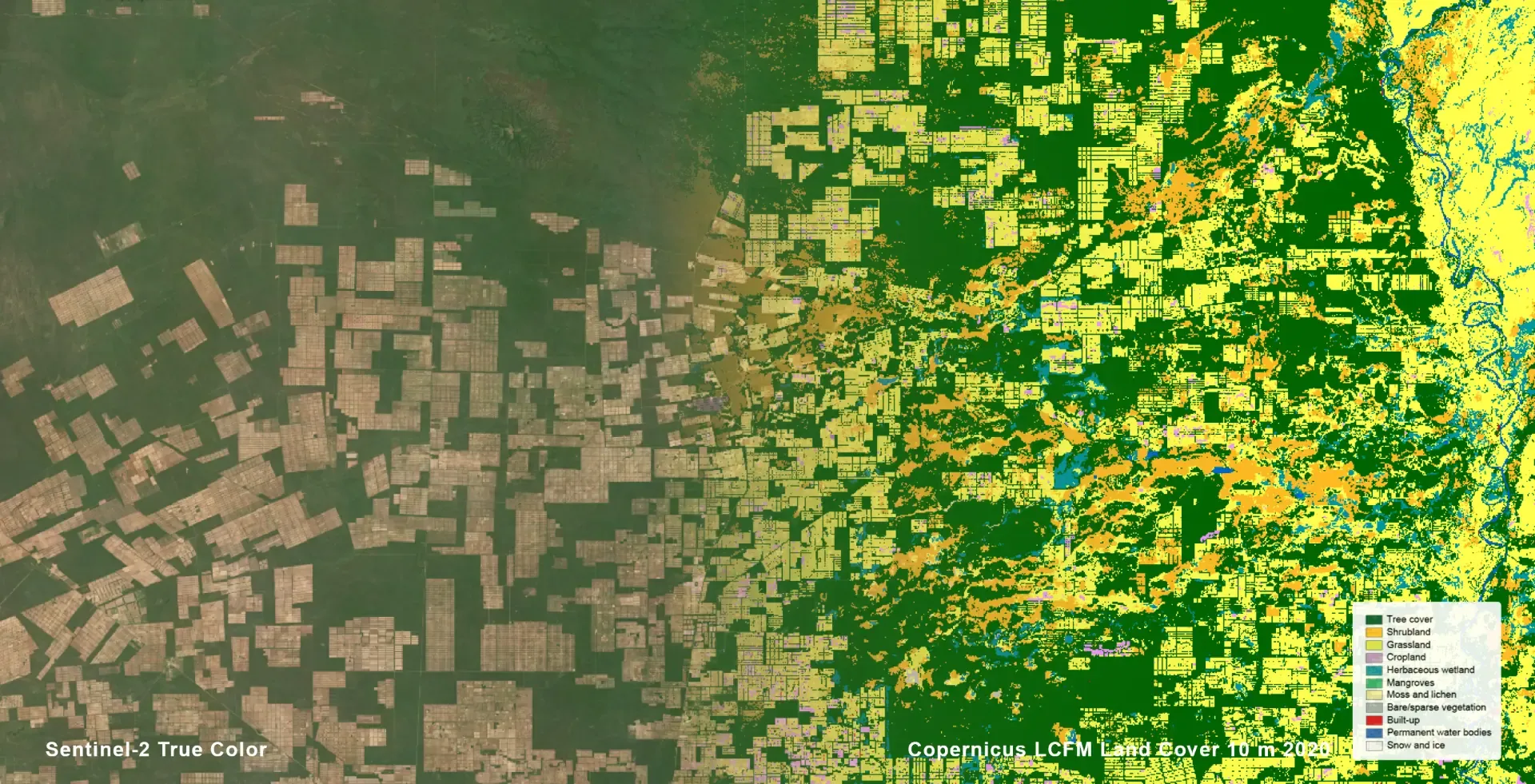
In South America’s Gran Chaco, one of the continent’s deforestation hotspots, forests are being cleared to make way for cattle ranching and soybean cultivation. With the LCM-10 product, patterns of land conversion can be detected down to individual plots, helping to monitor emerging deforestation trends, while time series analysis can also reveal recurring clearing cycles, often linked to speculative land use practices, in which land is cleared in anticipation of future sale or development.
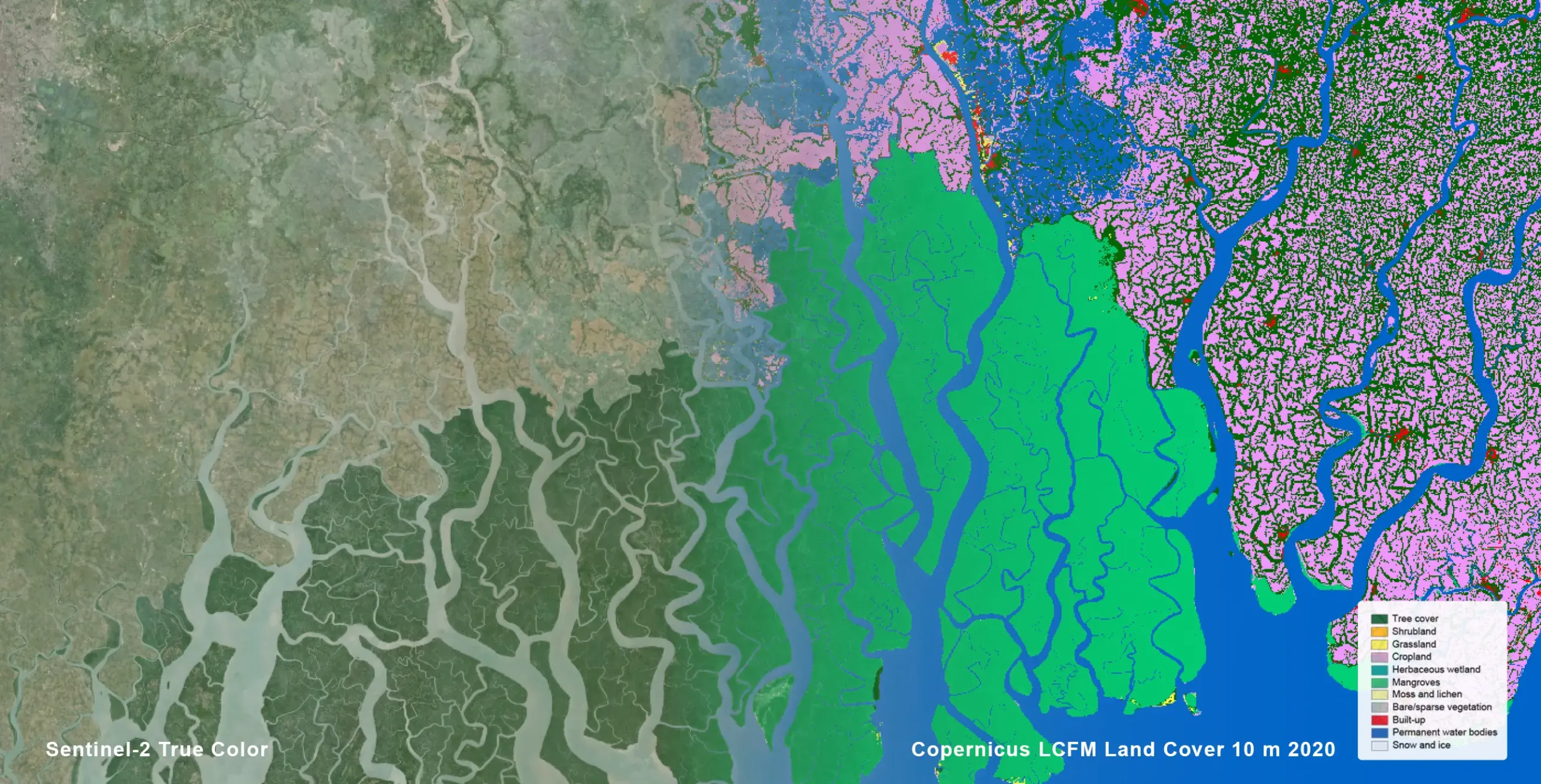
In the Sundarbans mangrove forests, one of the world’s most important coastal ecosystems, the new products introduce a dedicated class for mangrove, which store large amounts of carbon, protect coastlines from storms, and support rich biodiversity. Monitoring their extent with high precision strengthens efforts to safeguard these ecosystems, as LCFM allows mangroves to be distinguished from other forest types, reducing misclassification often affecting coastal zones, in which vegetation near water bodies have spectral characteristics similar to those of mangroves and forest types mix at the boundaries of mangrove-covered expanses. This separation also enables detection of small-scale degradation due to aquaculture expansion or changes in water salinity, details which are typically missed in coarser resolution products, and supports climate adaptation planning by identifying areas where mangrove loss increases exposure to storm surges.
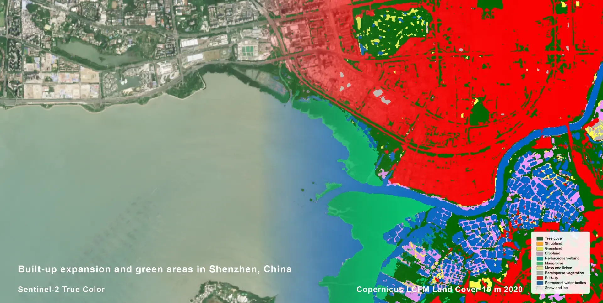
In rapidly growing cities such as Shenzhen in China, LCFM products reveal the pace of urban expansion and the distribution of remaining green spaces. By quantifying urban tree cover at high spatial resolution and distinguishing between built-up areas, sparse vegetation, and dense canopy woody areas, LCFM can help local authorities understand how development affects environmental quality and urban resilience, while supporting monitoring of urban greening policies and indicators related to heat mitigation and air quality. Repeated observations allow cities to track green space fragmentation over time, a key factor for urban biodiversity.
In the Wadi As-Sirhan Basin in Saudi Arabia, the map below shows the circular crop fields created by centre-pivot irrigation systems. These agricultural patterns highlight how farming expansion in arid regions depends on deep groundwater resources and affects surrounding ecosystems. LCFM allows the delineation of these circular fields and supports monitoring over time, providing insights into the expansion rate of irrigated agriculture.
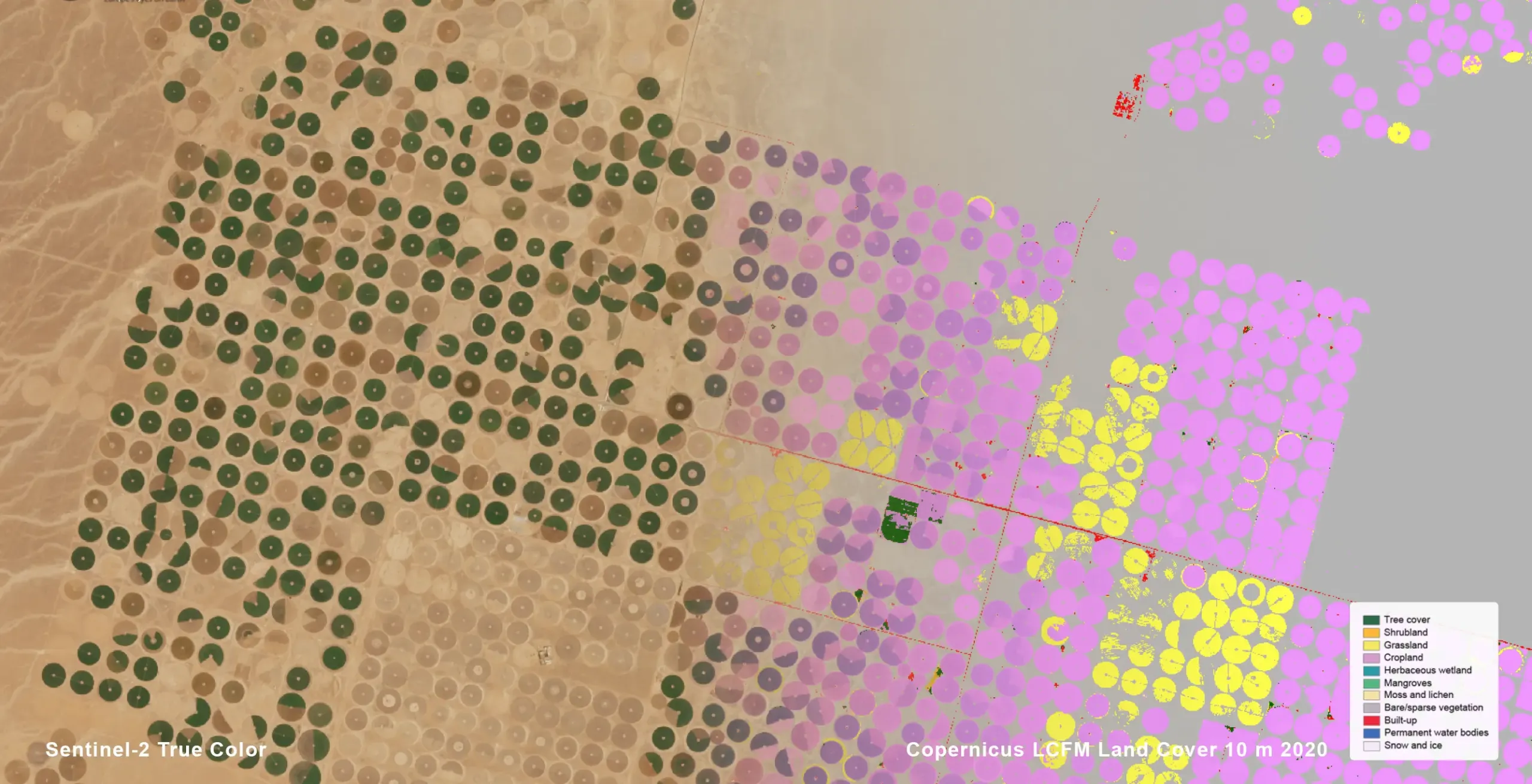
Combining land cover data with ancillary information makes it possible to assess pressure on groundwater resources, identify unsustainable extraction trends, and detect abandoned or inactive fields, providing evidence of resource depletion or changing agricultural practices.
Innovation-driven geospatial products
Producing global land cover maps at 10-metre resolution requires advanced data processing and artificial intelligence. The LCFM products rely on Copernicus Sentinel-1 and Sentinel-2 satellite data, processed through an improved data pipeline designed to remove residual clouds and improve the quality of time series data.
A key innovation is the EvoNet deep learning algorithm, developed specifically for global land cover mapping. EvoNet combines the strengths of convolutional neural networks, which capture spatial context, with pixel-level classifiers which preserve fine detail, enabling the model to identify both small features such as roads and larger landscape patterns such as cropland. This capability was developed through the Evoland EU-funded Horizon project.
Another key innovation is Evotrain, a global training dataset containing more than 54,000 expert-annotated locations, created using the Geo-Wiki Evolution platform, which allows experts to label land cover classes with the support of artificial intelligence tools. Together, these technological advances improve classification accuracy and make the maps more reliable across diverse landscapes.
Expanding the Copernicus land monitoring portfolio
The LCFM product suite will continue to expand its product suite in the coming years. New releases planned for 2026 include annual land cover maps for 2021–2025, as well as land cover change products (LCCM-10), which will help users visualise where and how landscapes are evolving. In parallel, CLMS will introduce monthly Land Surface Categories (LSC) maps which will make it possible to track seasonal land dynamics and identify rapid changes in the Earth’s surface.
Together, these products will form a comprehensive global catalogue for monitoring environmental change. By combining high spatial resolution, consistent time series, and open access, the Copernicus LCFM products provide new levels of insight into how our planet’s landscapes are transforming, delivering valuable tools for protecting ecosystems and supporting sustainable land management worldwide.