
OBSERVER: New satellite to carry the Copernicus Sentinel-3 record into the next decade
Sentinel-3C marks the next step in a satellite mission which has monitored Earth's oceans, land, ice, and atmosphere since 2016. Its payload will continue monitoring sea surface temperature and height, ocean colour, land surface temperature, vegetation, ice, and atmospheric conditions. These observations support applications such as wildfire response, heatwave and drought assessment, marine monitoring, and environmental management. In this Observer, we present the Sentinel-3 mission, its capabilities, and the applications supported by its data, before looking ahead to how Sentinel-3C will extend the mission's observation record into the 2030s.
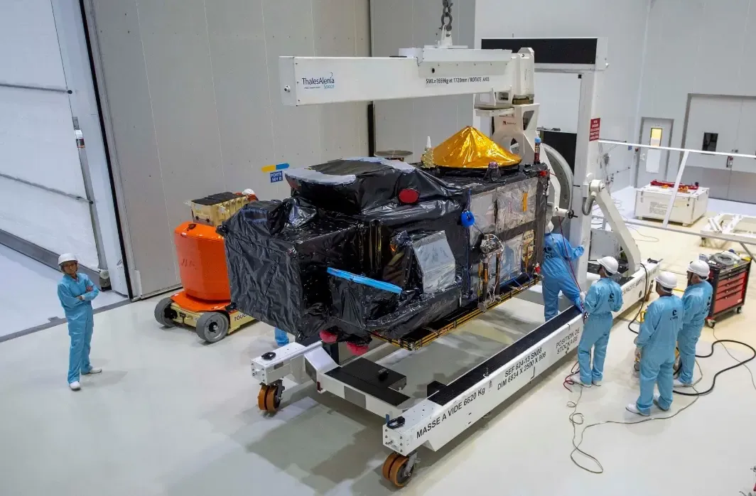
Carrying four main instruments designed to work in parallel, Sentinel-3 is one of the most technically complex missions in the Copernicus Sentinel family. Since Sentinel-3A was launched in 2016, the Copernicus Sentinel-3 mission has provided regular observations of Earth's oceans, land, ice, and atmosphere. Sentinel-3C will extend this long-term record as the next satellite in the established series. Its launch is scheduled for 22:21 local time in Kourou on 14 September 2026, or 01:21 UTC on 15 September, with further mission updates and information on how to watch the launch available on the EU Space website. Avio's Vega-C will carry the satellite into a Sun-synchronous orbit around 820 km above Earth. It will first operate alongside Sentinel-3A and Sentinel-3B, launched in 2016 and 2018, respectively. After in-orbit testing and commissioning, Sentinel-3C will take over Sentinel-3A's primary operational role. This transition will maintain the mission's two-satellite configuration and regular flow of observations.
Sentinel-3C will carry the same payload as its predecessors. The Ocean and Land Colour Instrument (OLCI) is a push-broom imaging spectrometer with a wide field of view designed to reduce sun-glint contamination. It measures reflected light across 21 spectral bands at a spatial resolution of up to 300 m, supporting observations of ocean colour, vegetation, land surfaces, and atmospheric conditions. The Sea and Land Surface Temperature Radiometer (SLSTR) uses a dual-view scanning system across nine spectral bands at a spatial resolution ranging between 500 m and 1 km. It measures marine and terrestrial surface temperatures for a range of climate and environmental applications, while two dedicated thermal infrared channels support active-fire detection. SLSTR data are used to derive the Fire Radiative Power (FRP) variable, which estimates the rate of outgoing thermal energy from a burning wildfire. The Synthetic Aperture Radar Altimeter (SRAL) measures sea surface height, waves, and ocean-surface wind speed, while also observing inland waters and ice. Its SAR altimetry technology provides high-resolution measurements at approximately 300 m along-track (the direction in which the satellite is moving along its orbital path), improving the detail and accuracy of observations compared with conventional altimetry. The Microwave Radiometer (MWR) measures atmospheric water vapour at approximately 20 km resolution and provides corrections to improve SRAL's accuracy.
Taking the pulse of a changing planet
Sentinel-3 provides frequent observations across the ocean, land, ice, and atmosphere, supporting both daily environmental monitoring and analysis of longer-term change. It measures variables such as sea surface topography, sea and land surface temperature, and ocean and land colour. Over the ocean, these observations contribute to ocean forecasting, marine ecosystem monitoring, algal bloom detection, and sea level analysis. Altimetry also provides information on wave height, inland water levels, sea ice, and ice sheets. Over land, Sentinel-3 records land surface temperature and vegetation conditions, while aerosol and cloud information provide atmospheric context. The Copernicus Land Monitoring Service (CLMS) draws on these observations, using Sentinel-3 OLCI data to produce global 10‑day composites at 300 m resolution for key vegetation indices, such as Leaf Area Index (LAI), Fraction of Absorbed Photosynthetically Active Radiation (FAPAR), and Fraction of Green Vegetation Cover (FCover). These are complemented by water and snow products, including Lake Surface Water Temperature at 1 km resolution on a 10‑day basis and Snow Cover Extent at 1 km resolution daily, derived from Sentinel-3 SLSTR. Together, these products provide a consistent basis for tracking vegetation growth, snow conditions, and water characteristics over time.
Sentinel-3 builds on earlier European observation records which extend back more than two decades. SLSTR builds on Envisat's Advanced Along-Track Scanning Radiometer (AATSR) heritage for global sea surface temperature observations, while OLCI follows Envisat’s Medium Resolution Imaging Spectrometer (MERIS) with additional spectral bands and improved observation capabilities. Sentinel-3’s altimetry capability, which includes SRAL and MWR, builds on technology developed for Envisat. SRAL also draws on technology from CryoSat and the Jason missions. Sentinel-3 measurements complement those of Copernicus Sentinel-6, which extends the long-term sea level record and provides reference measurements for calibrating other satellites’ altimetry data. Sentinel-3 SYNERGY vegetation products also continue aspects of the SPOT-VEGETATION data record through combined OLCI and SLSTR observations. Sentinel-3C will carry these established capabilities into the next phase of the mission, supporting applications such as wildfire and heat monitoring, marine monitoring, and cryosphere observations.
From observations to real-world applications
Wildfire monitoring illustrates how Sentinel-3 can support operational users during rapidly evolving events. To make these observations available more quickly, selected Sentinel-3A and Sentinel-3B passes over southern and central Europe have, since 3 August 2026, reached users in about 90 minutes, compared with the usual delivery time of up to three hours for near-real-time (NRT) products. Introduced in response to requests from the Copernicus user community, this faster delivery provides earlier access to observations of evolving fire conditions.
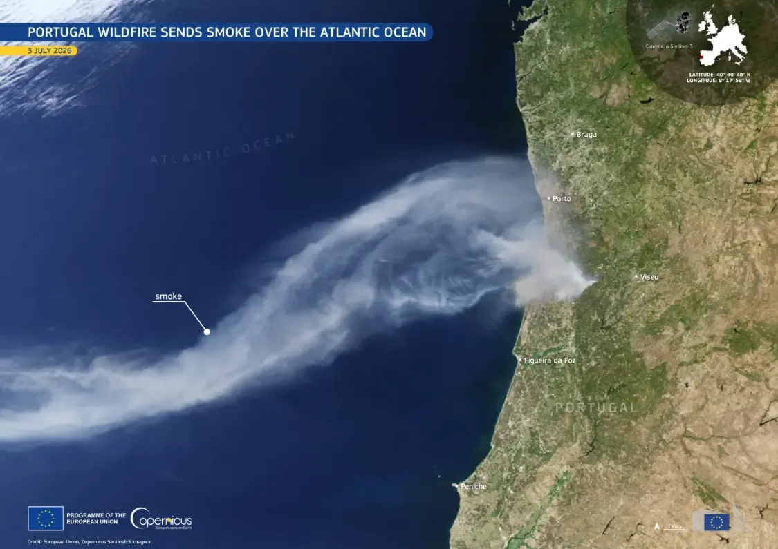
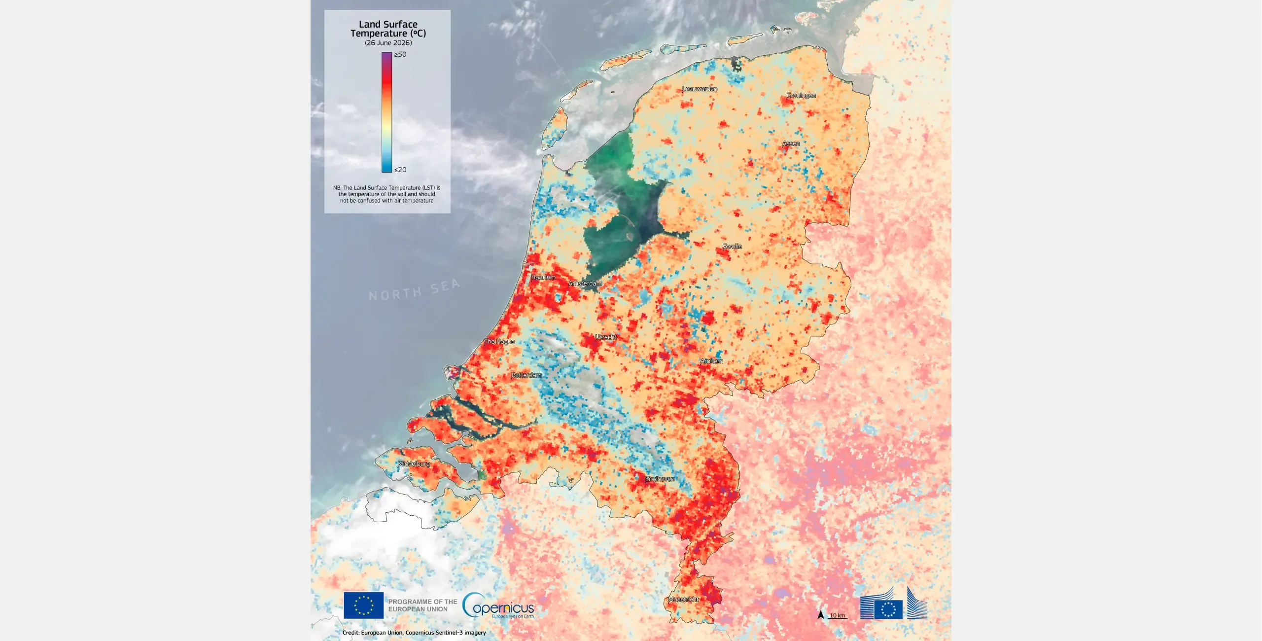
Beyond wildfire monitoring, Sentinel-3 supports a wide range of applications across land, ocean, ice, and atmosphere. Its broad coverage allows observation of environmental conditions over large areas and over time. In the summer of 2026, for example, Sentinel-3 data showed extensive areas of central and southern France and northern Spain where land surface temperatures exceeded 50°C. The summer heatwave also affected countries farther north, including the Netherlands, where Sentinel-3 recorded land surface temperatures above 45°C. Unlike air temperature, land surface temperature, as an Essential Climate Variable which helps characterise Earth's climate, depicts surface temperature and provides information on the magnitude and spatial extent of soil heating. Such observations can support assessments of thermal conditions affecting agriculture, natural ecosystems, and other heat-sensitive environments.
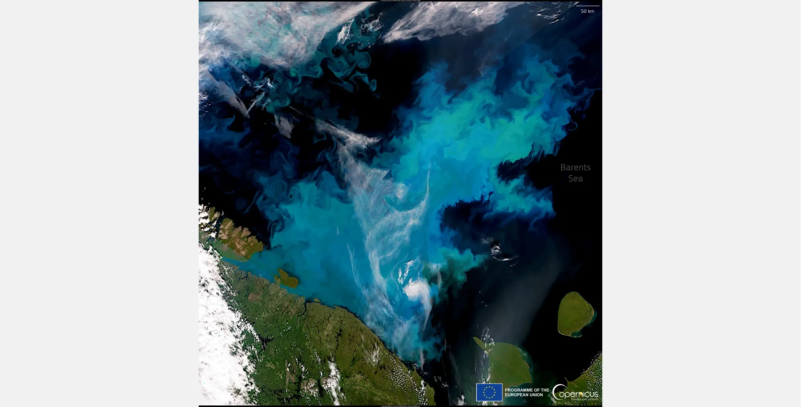
In marine environments, Sentinel-3 provides information on ocean colour, which supports monitoring of phytoplankton activity. OLCI data can be used to derive chlorophyll-a concentration, which serves as an indicator of phytoplankton biomass and provides information on marine ecosystem productivity. In the example below, the large bloom observed north of the Scandinavian Peninsula in August 2023, spanning more than 200,000 km², illustrates how Sentinel-3 can capture the extent of such events and support analysis of their potential implications for marine ecosystems, fish resources, and global climate.
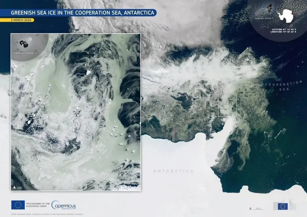
In polar regions, Sentinel-3 provides broad spatial context across ice-covered waters and for ocean-colour features. In March 2026, for instance, the mission captured green-tinted waters associated with a phytoplankton bloom along the eastern Antarctic coast, while Sentinel-2 imagery showed the phenomenon at a finer spatial resolution. The example illustrates how Copernicus Sentinel satellite missions can complement one another by combining wide-area monitoring with more detailed observations.
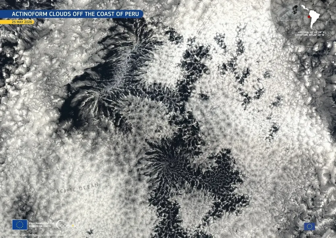
Sentinel-3 also provides information on aerosols and cloud formations, helping users interpret surface conditions alongside atmospheric processes. By observing several components of the Earth system over large areas, it can place individual events within a broader environmental context.
Keeping Copernicus observations flowing into the future
Maintaining this range of observations over time depends on the sustained operation and renewal of the Sentinel-3 series. Sentinel-3C is part of the planned renewal of the constellation, with Sentinel-3D expected to follow in 2029. Sentinel-3A and Sentinel-3B have both exceeded their design lifetimes but continue to operate, supporting observations as the next-generation satellites are introduced.
Sentinel-3C's launch aboard Vega-C from Europe's Spaceport also highlights the role of European launch capabilities in sustaining the Copernicus Sentinel-3 constellation continuity and supporting Europe's autonomous access to space. Together, Sentinel-3C and Sentinel-3D are intended to extend the availability of Sentinel-3 observations into the 2030s, supporting environmental monitoring and operational services while preserving the long-term record needed to track changes across the ocean, land, ice, and atmosphere.
Learn more about Sentinel-3C and how you can watch the launch here.