
OBSERVER: A summer of fire – how Copernicus monitored Europe’s 2026 wildfire season
Europe’s 2026 wildfire season began early, after the warmest June on record in western Europe, and ran into September. Wildfires reached the capital regions of Paris and Madrid, and in Eastern Belgium, fires smouldered for days in the protected peatlands of the High Fens. The Copernicus Emergency Management Service (CEMS) supported preparedness and response operations across the season, combining the regular monitoring provided by the European Forest Fire Information System (EFFIS) with On-Demand Mapping of specific wildfires. In this Observer, we look at how the season unfolded and how satellite-based emergency mapping activities complemented a record European wildfire preparedness effort.
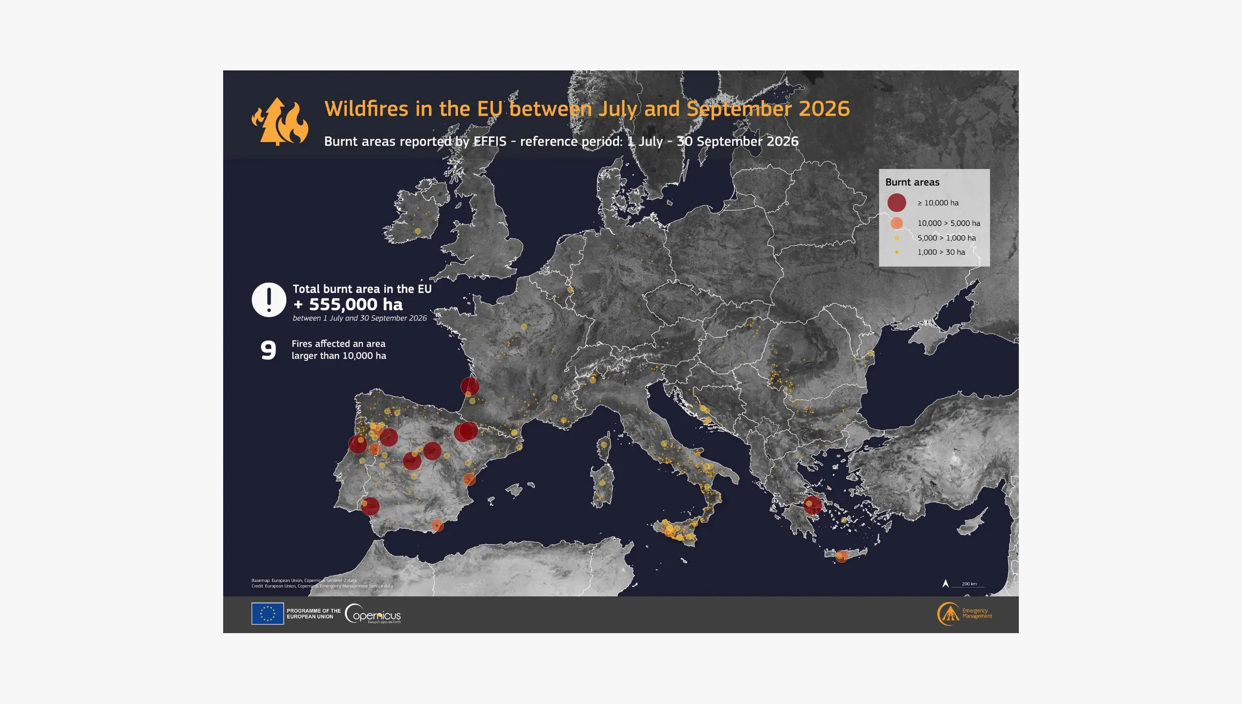
An early start, and a long summer of Copernicus EMS activations
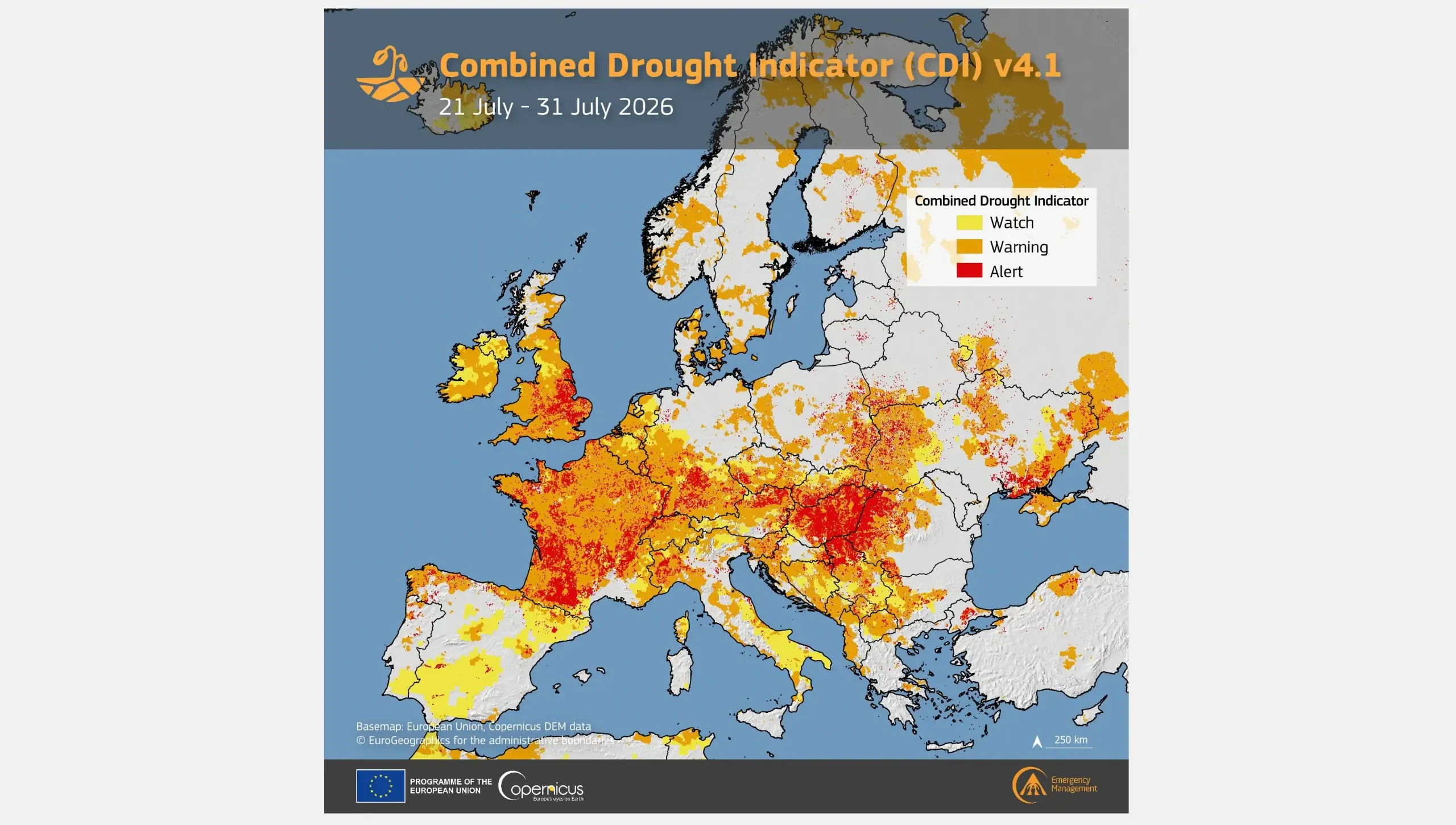
Conditions favouring wildfires were in place well before the first large fires broke out. According to the Copernicus Climate Change Service (C3S), June 2026 was the second-warmest June on record globally and the warmest on record in western Europe, with a rainfall deficit and low soil moisture across much of the continent.
The European Drought Observatory (EDO), part of the Copernicus Emergency Management Service (CEMS), enabled the monitoring of those conditions as vegetation dried out and the amount of fuel available to burn increased. The European Forest Fire Information System (EFFIS) tracked the fire danger itself, issuing daily forecasts based on numerical weather predictions to indicate how readily a fire might start and spread, and alerting civil protection authorities to the days and areas of peak danger. Its long-term forecasts look months rather than days ahead, and inform decisions taken before a season begins, such as the prepositioning of firefighting resources.
Requests for emergency mapping products followed the increase in wildfire activity. By 30 September 2026, CEMS had received 47 Rapid Mapping activation requests for wildfires, compared with 34 for the whole of 2025. Each activation begins with a request from an Authorised User, normally a national civil protection authority or the EU Emergency Response Coordination Centre (ERCC), after which the service delivers emergency maps within hours of receiving suitable satellite imagery. The highest annual figure recorded for wildfires remains 54, in 2022.
These requests were not evenly spread throughout the summer. In the last week of July, near-simultaneous large fires in Spain, France, and Greece led to several activations running in parallel, with mid-August bringing a second wave of large wildfires. CEMS also supported wildfire response operations in Belgium, Germany, and the UK. CEMS On-Demand Mapping was also requested to support the monitoring of a wildfire in Greenland, which broke out on 14 June above the Arctic Circle, under activation EMSR883.
What the figures show
The number of CEMS activations does not, on its own, measure how severe a wildfire season is. Because CEMS delivers On-Demand Mapping products following an official request, the activation count reflects how often authorities called on the service. EFFIS, by contrast, provides regularly updated forecasts, near-real-time detection of active fires, and a season-long record of burnt areas.
According to EFFIS, slightly over 686,000 hectares had burnt in the EU by 30 September 2026, from around 2,150 fires, an area more than two and a half times the size of Luxembourg. The total sits well below the 1,027,351 hectares recorded by the same date in 2025, the worst year on record, but close to twice the 2006–2025 average for early September.
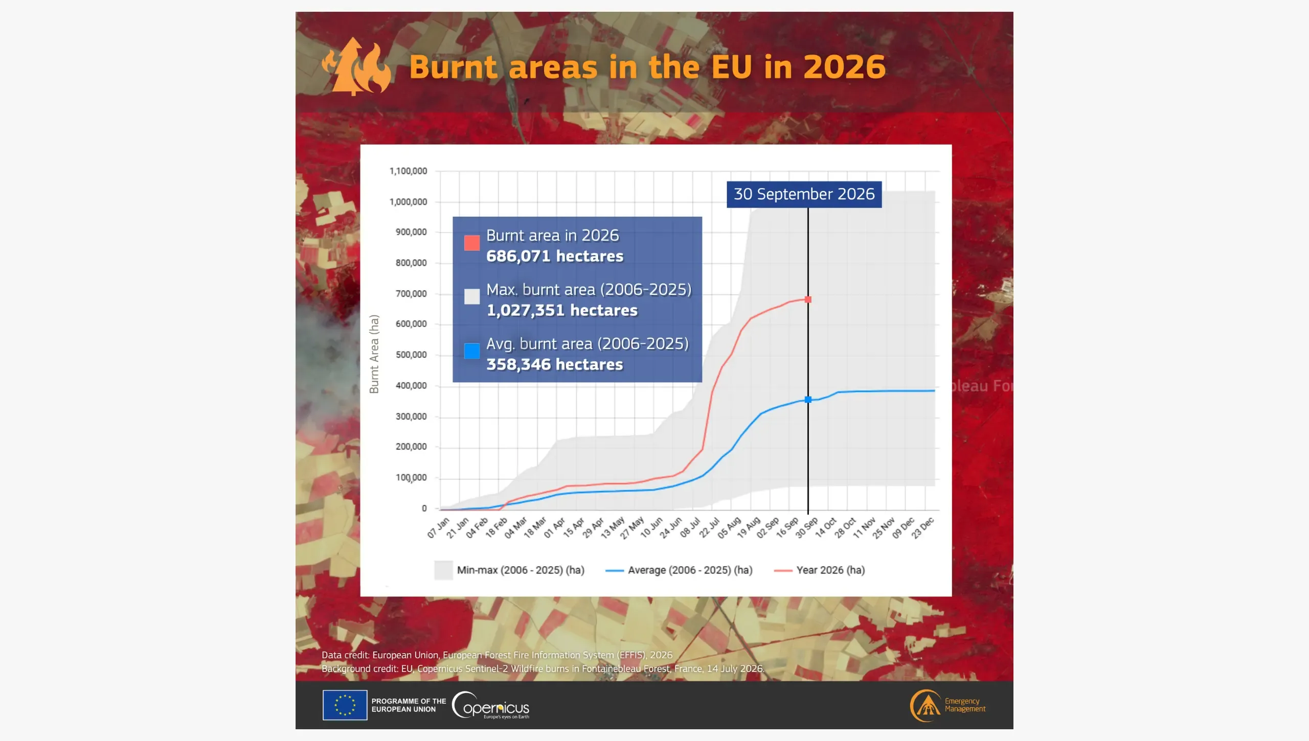
Activation counts and burnt-area totals highlight different aspects of a wildfire season. Burnt-area totals show how much land was affected, while activation counts reflect how often authorities requested emergency mapping. For large fires, satellite mapping can help authorities assess the extent of the affected area without relying solely on observations from the ground. However, an authority’s decision to request emergency mapping can be influenced not only by a fire’s size but also by its location. In 2026, the number of wildfires recorded was similar to that recorded in 2025, yet authorities submitted more wildfire mapping requests to CEMS. On-Demand Mapping activations are typically triggered when wildfires threaten people, housing, transport links, or protected areas, so the higher demand is an indication of not only the scale of the fires but also the assets and populations threatened by them.
Several developments may help explain this increase. In recent seasons, large wildfires have also affected areas farther north, including countries in which wildfires of this size have traditionally been rare. Belgium recorded the largest wildfire in its history, and North Rhine-Westphalia its largest since records began. Neither accounted for a large share of the EU’s total burnt area, yet each was unusual in its national or regional context. In addition, several major wildfires in 2026 spread closer to populated areas, prompting evacuations and threatening motorways and rail links on the approaches to major cities. In France, for example, wildfires burnt unusually close to densely inhabited areas and, by the end of July, EFFIS had recorded France’s largest annual burnt area on record, well before the usual late-summer peak.
Closer to cities, and further north
Three of the season's most significant wildfires occurred near major populated areas, while a fourth burnt in a region in which events of this scale have been rare.
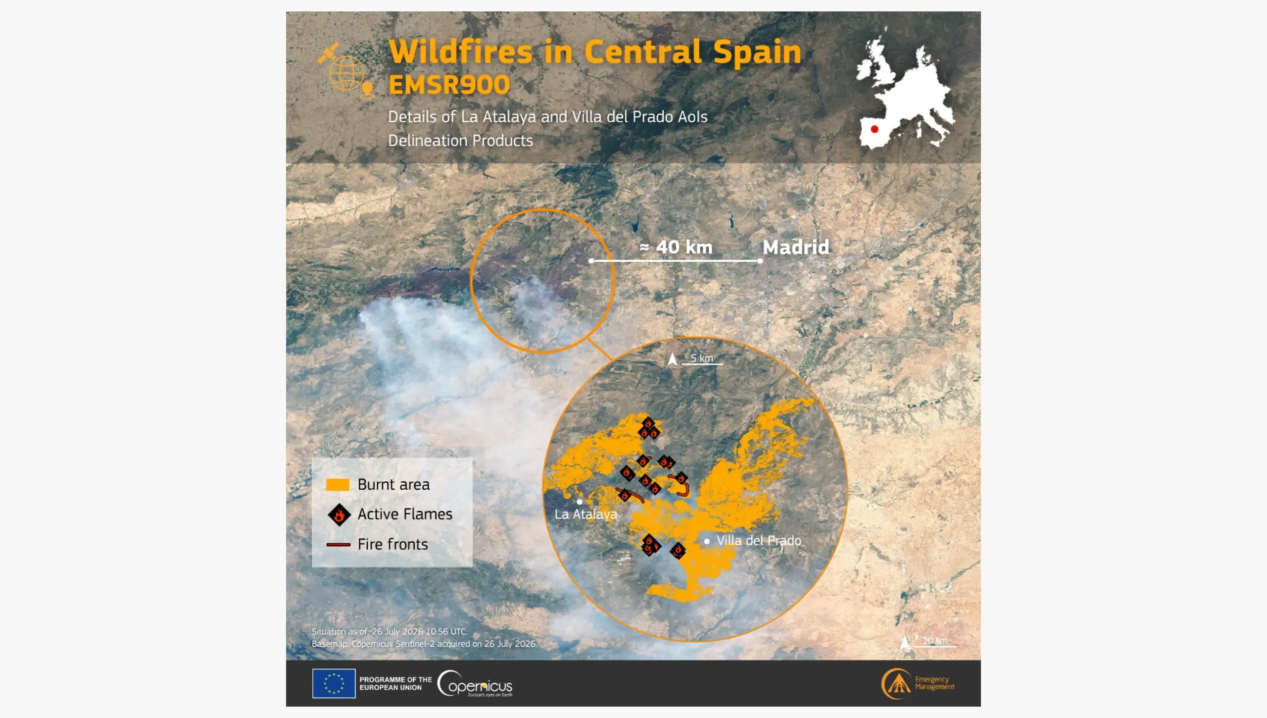
In July, wildfires reached the Community of Madrid, in Spain. A first fire broke out at Brieva, in the province of Segovia, on 20 July, while a second broke out two days later near Almorox, in the province of Toledo, and spread into Villa del Prado. The area delineated within activation EMSR900 lay around 40 km from Madrid. Regional authorities received an initial estimate of the extent of the fires while residents were still being evacuated, with delineation products following as the fire fronts developed. CEMS Rapid Mapping delivered 55 maps across seven areas of interest, identifying 2,914 buildings and an estimated 6,200 people as affected.
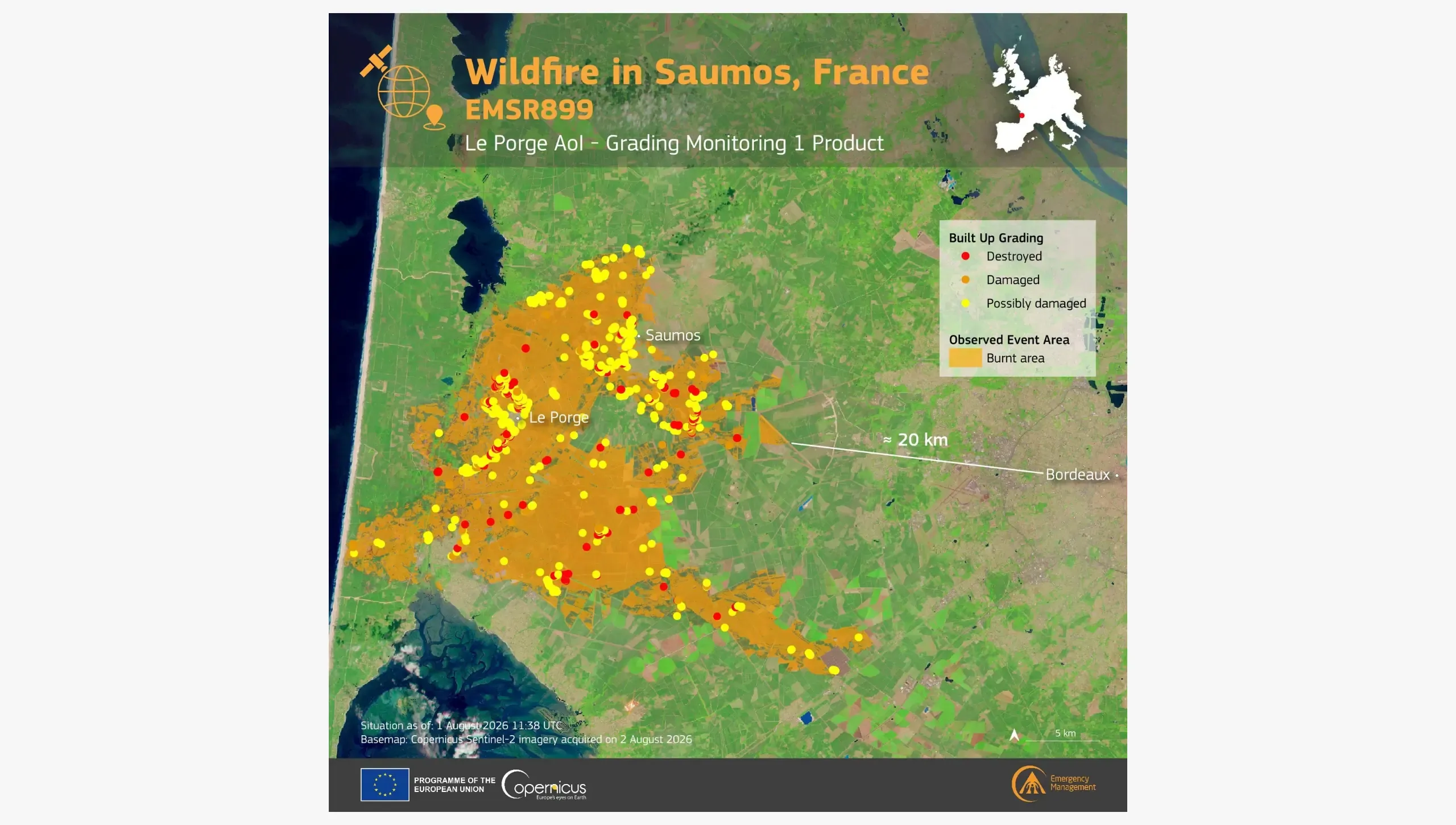
A similar situation unfolded in south-western France. Two wildfires (EMSR899, EMSR902) which broke out around Arcachon Bay in late July spread through an area popular with summer residents and visitors, prompting the precautionary evacuation of more than 220,000 people. One of the wildfires was put under control roughly 20 km from Bordeaux, showing how rapidly wildfires can intersect with densely populated areas. CEMS Rapid Mapping had recorded a burnt area of 34,600 hectares in Saumos, with 1,398 buildings and an estimated 2,400 people affected.
Earlier in the month, on 12 July, a wildfire broke out in the Fontainebleau Forest, about 60 km south-east of Paris, threatening housing, transport links, and key infrastructure in the wider Île-de-France region (EMSR894). Although far smaller than some other 2026 wildfires, its proximity to one of Europe's largest metropolitan areas made rapidly available geospatial information particularly important for emergency responders.
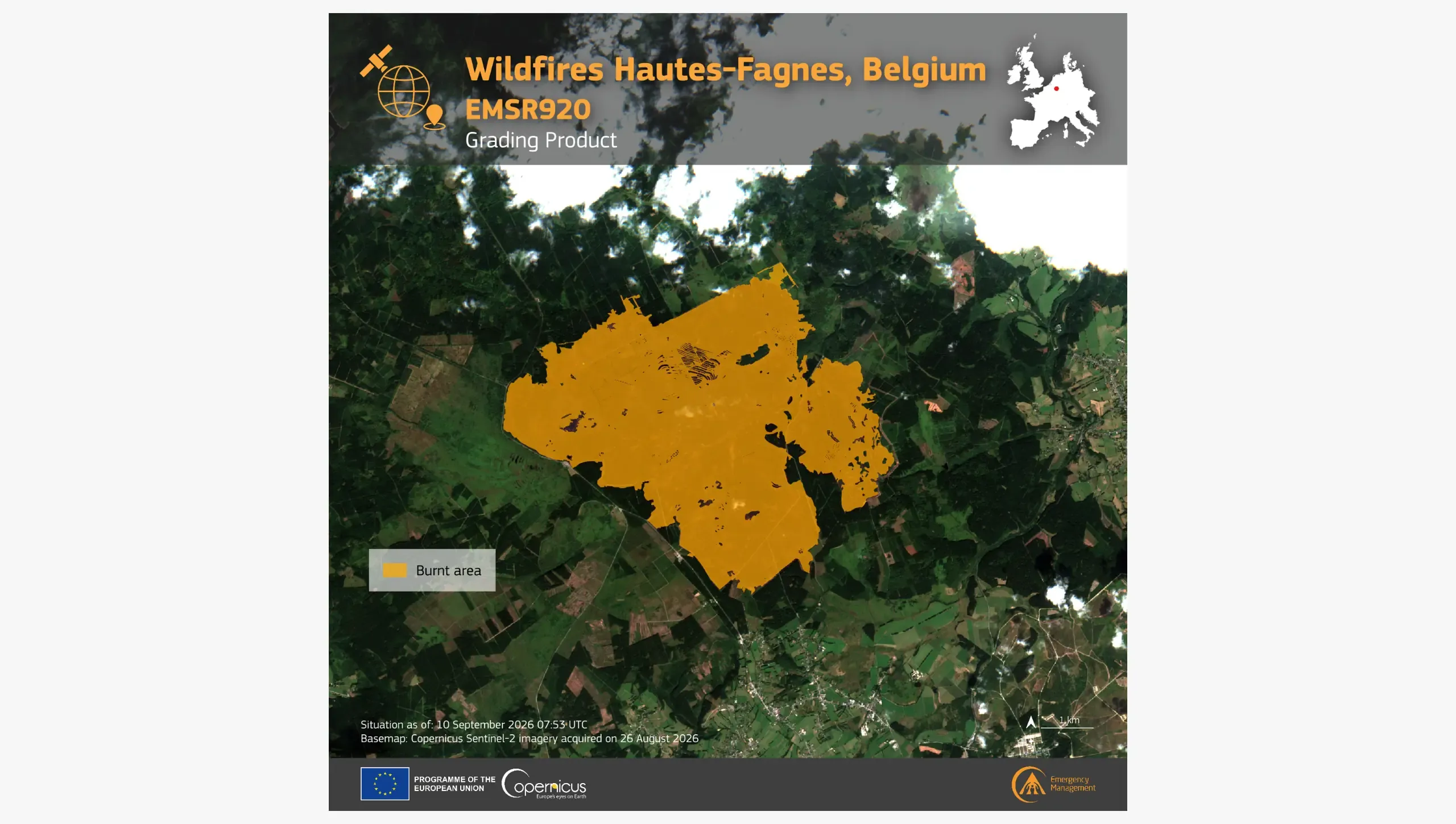
The clearest break with the Mediterranean pattern came in mid-August, when wildfires burnt on both sides of the German-Belgian border. CEMS On-Demand Mapping was activated on 14 August 2026 (EMSR920) to map the area affected by the wildfire in the Hürtgen Forest, in the county of Düren in North Rhine-Westphalia, and a separate fire in the High Fens, a protected peatland in eastern Belgium. Peat can continue burning below the surface, and the Belgian fire remained active long after the visible flames were extinguished. It required sustained monitoring and cross-border coordination between response teams from several European countries, with aircraft arriving from Sweden, the Netherlands, Norway, and Germany. CEMS Rapid Mapping delivered seven emergency products, recording a burnt area of 2,690 hectares in the High Fens.
Supporting Europe's response to changing wildfire risk
Satellite data can help map the extent of wildfires and their impacts on communities, transport corridors, utilities, and protected ecosystems without relying solely on ground surveys. The 2026 wildfire season demonstrated how satellite-based information is an integral part of Europe's emergency response system. As several large wildfires developed simultaneously across the continent, CEMS products contributed to the situational awareness of national and regional civil protection authorities and the ERCC, supporting operational decision-making and cross-border coordination.
In mid-August 2026, CEMS was supporting local authorities responding to wildfires in Belgium, Spain, Greece, Germany, Montenegro, Serbia, Albania, France, and Italy. At the same time, the EU Civil Protection Mechanism (UCPM) coordinated its largest wildfire preparedness and response effort to date. Between 1 July and 15 September 2026, 777 firefighters from 14 European countries were prepositioned in Cyprus, Greece, Italy, France, Spain, and Portugal, the highest participation since the scheme began in 2022. The EU also kept 22 firefighting aircraft (14 medium amphibious planes and 8 light aircraft) and 5 helicopters on standby through rescEU, while ERCC wildfire experts provided round-the-clock analytical and scientific support to deployments.
The European Commission is also strengthening its longer-term approach. On 25 March 2026, it presented a new Communication calling for an integrated approach to wildfire risk management, covering prevention, preparedness, response, and recovery. The approach builds on the Preparedness Union Strategy of 26 March 2025. Among its proposals are further improvements to EFFIS early warning and monitoring, and a roadmap for producing regularly updated fuel maps across Europe, showing the distribution and condition of vegetation which can fuel wildfires.
The 2026 season showed how wildfire risk is changing in Europe. Fires are affecting regions where large wildfires have traditionally been rare, threatening densely populated areas, and demanding closer coordination between monitoring, preparedness, and response activities. Through drought monitoring, fire-danger forecasts, and emergency mapping, Copernicus helps Europe prepare for, and respond to, wildfires.