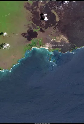
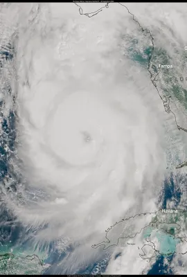
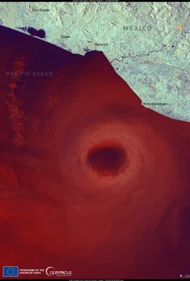
European Union flag
EU Space Policy

Explore EU Space

Results (558)
Image of the Day
The Impact of the Floods South of Valencia through the eyes of Copernicus Sentinel-2
Earth Observation | Copernicus
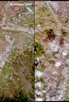
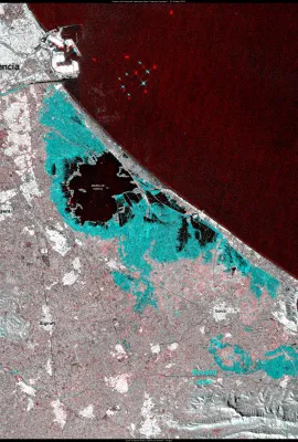
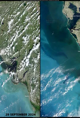
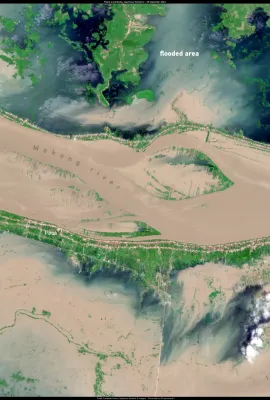
This data visualisation compares two Copernicus Sentinel-2 satellite acquisitions over the area south of Valencia, Spain, captured on 26 and 31 October 2024, before and after the devastating floods which hit the area during the evening of 29 October. On 26 October, the area appears well delineated, with clear separations between densely...
Image of the Day
Disastrous floods south of Valencia, Spain
Earth Observation | Copernicus
Parts of southern and eastern Spain are still reeling from the effects of flash flooding after record rainfall hit the region on 29 and 30 October 2024. Over 150 deaths have been reported, making this the country’s deadliest natural disaster in decades. On 31 October, emergency operations continued to rescue stranded residents and locate...
Image of the Day
Devastating Flooding in Valencia, Spain
Earth Observation | Copernicus
On 29 October 2024, parts of southern and eastern Spain were affected by severe flash flooding following record rainfall. Dozens of deaths have been reported as emergency workers continue operations to rescue stranded residents from their homes and cars. Over 1,000 soldiers from Spain’s emergency response units have been deployed to support...
Image of the Day
Devastating flooding in the Far North region of Cameroon
Earth Observation | Copernicus
Since July 2024, heavy rainfall and rising water levels in major rivers, including the Chari River, have caused severe flooding in the Far North region of Cameroon, affecting more than 400,000 people as of 11 October 2024.  The flooding has impacted schools, health centres, and farmland. In neighbouring Chad, approximately two million people...
Image of the Day
Floods Italy
Earth Observation | Copernicus
After being impacted by torrential rainfall and subsequent flooding from Storm Boris in September 2024, on 19 October the Italian region of Emilia-Romagna has been affected by another severe episode of flooding after days of heavy rainfall. Several rivers in the region have reached critical levels, with many others overflowing. At least 3,000...
Image of the Day
Biodiversity in the Galapagos Islands, Ecuador
Earth Observation | Copernicus
The Galápagos Islands of Ecuador, known for their unique and robust biodiversity, face increasing threats from climate change. Rising ocean temperatures have impacted local wildlife, making it more difficult for species such as marine iguanas and sea turtles to find food and nest. While temperatures in the Galápagos naturally fluctuate with the...
Image of the Day
Rising sea levels threaten Panama’s San Blas islands
Earth Observation | Copernicus
With a rising water level of 3.4 millimetres annually, the islands of the Panamanian archipelago of San Blas are at high risk of being submerged, and researchers predict that they will be uninhabitable by the end of the century. The rising sea levels are impacting both residents and tourists. In the past year, some of the Guna people of the San...
Image of the Day
The consequences of Hurricane Milton, USA
Earth Observation | Copernicus
On 9 October 2024, Hurricane Milton struck the western coast of Florida, USA, bringing tornadoes, extreme wind, and torrential rainfall to the region. Milton was the third-fastest intensifying Atlantic hurricane on record, strengthening to a Category 5 storm in under 24 hours before decreasing to a Category 3 storm before making landfall. A...
Image of the Day
Rising sea levels affect Delos Island, Greece
Earth Observation | Copernicus
A new study suggests that coastal historical sites in Greece are at risk of being submerged by the end of the century due to rising sea levels driven by global warming. The researchers created flood risk maps based on local and global predictions to assess 464 historical sites along the Eastern Mediterranean coast, finding that 147 of these...
Image of the Day
Key findings on sea ice from the EU Copernicus Ocean State Report (OSR 8)
Earth Observation | Copernicus
The Copernicus Marine Service (CMEMS) published the EU Copernicus Ocean State Report (OSR 8) on 30 September 2024, an annual publication which provides information on the current conditions and changes in European and global bodies of water. A key finding of the report is that there has been a loss of nearly 2.2 million km² of Arctic sea ice...
Image of the Day
Milton
Earth Observation | Copernicus
On 9 October 2024, Hurricane Milton made landfall in Florida as a Category 3 storm, impacting a region still reeling from the devastation caused by Hurricane Helene just weeks earlier, which resulted in widespread destruction and hundreds of fatalities. Milton unleashed tornadoes and winds exceeding 160 kilometres per hour, leaving more than...
Image of the Day
September 2024, the second-warmest September on record
Earth Observation | Copernicus
The  Copernicus Climate Change Service (C3S) has published its latest monthly Climate Bulletin, highlighting significant climate trends. September 2024 marked the second-warmest September on record, following September 2023, with temperatures 0.73°C above the average for that month from 1991 to 2020. Additionally, it was 1.54°C warmer than the...
Image of the Day
Copernicus in Emergencies
Earth Observation | Copernicus
In the face of natural or man-made disasters, the Copernicus Emergency Management Service (CEMS) provides On-Demand Mapping services  leveraging satellite imagery and other geospatial data. This information is key to supporting  response and recovery efforts around the globe, particularly regarding floods, earthquakes, landslides, hurricanes,...
Image of the Day
Hurricane Kirk
Earth Observation | Copernicus
This Copernicus Sentinel-3 image from 3 October 2024 shows Hurricane Kirk when it was about 2,000 km southwest of the Azores Archipelago. On the same day on which the image was acquired, Kirk swelled to a Category 4 storm in the central Atlantic Ocean as it made its way northeast, skirting the Caribbean islands and the eastern coast of the...
Image of the Day
The Hollandse Kust wind farm, the Netherlands
Earth Observation | Copernicus
This year, over half of the Netherlands' electricity has been produced from renewable sources like wind and solar power. In total, 32.3 billion kilowatt-hours were generated from renewables, accounting for 53% of the country's electricity production. Wind energy saw a significant increase, rising by a third to 17.4 billion kilowatt-hours, with...
Image of the Day
Wildfire in the Peloponnese region of Greece
Earth Observation | Copernicus
On 29 September 2024, a wildfire broke out in the Peloponnese (Greece), prompting the evacuation of several villages. 350 firefighters were dispatched to battle the blaze, which spread rapidly due to strong winds. At least two deaths caused by the fire have been reported. Greece has been affected by more than 4,500 wildfires during the summer...
Image of the Day
Cambodia floods
Earth Observation | Copernicus
As of September 2024, nine provinces in Cambodia have been affected by severe flooding, which has damaged thousands of homes and led to the evacuation of hundreds of families. At least 9,000 hectares of rice paddies have been impacted by the flooding.  Authorities have issued warnings to residents living along the Mekong River, the waters of...
Image of the Day
Helene storm
Earth Observation | Copernicus
Hurricane Helene made landfall in northwestern Florida, USA, on 26 September 2024 as a powerful Category 4 storm and one of the largest storms in the Gulf of Mexico in the last century. With maximum sustained winds reaching 225 kilometers per hour, Helene triggered widespread hurricane, wind, and flash flood watches and warnings for 60 million...
Image of the Day
Hurricane John makes landfall in Mexico
Earth Observation | Copernicus
On 23 September 2024, Hurricane John, a Category 3 storm, made landfall on Mexico’s southern coast, bringing winds of 190 kilometres per hour. By 24 September, the hurricane had weakened to a tropical depression with winds of 55 kilometres per hour. In its wake, John left behind damaged infrastructure and power outages. At least three people...
Image of the Day
Record temperatures in southern Greenland
Earth Observation | Copernicus
During the night of 22 September 2024, the air temperature in the town of Narsarsuaq in southern Greenland reached a record high of 15.3°C. This was the hottest September night in the area's recorded history and one of the highest minimum temperatures ever recorded in Greenland.  High temperatures continued throughout the following days....

Showing 201-220 of 558 results