
OBSERVER: From Arctic sea ice to secure connectivity, how the EU and Canada collaborate in space applications
The EU and Canada have cooperated on space applications for decades. Today, they share Earth Observation (EO) data through Copernicus, and their data and services support the monitoring of Arctic sea ice and wildfires, the detection of methane emissions, and the analysis of climate risks. The two sides are also collaborating on Galileo satellite navigation and discussing possible cooperation on secure connectivity through IRIS² and GOVSATCOM. In this Observer, we look at how the EU Space Programmes support the partnership between the EU and Canada, and at what this cooperation brings to users on both sides of the Atlantic.
The EU Space Programmes bring together Copernicus, the Earth Observation (EO) component; Galileo, the global navigation satellite system; and the secure connectivity components IRIS² and GOVSATCOM. Through international cooperation, the EU shares the data and services of the Programmes with partners around the world, and draws on their capabilities in return. Canada is one of these partners, and its radar satellites, in situ measurements, and companies specialised in EO complement the EU Space Programmes’ satellites and services.
Canada is an Arctic state, as are three EU Member States, so both partners have a direct stake in the region. According to the new EU Strategy for the Arctic, presented by the European Commission and the High Representative on 20 October 2026, the region is warming nearly four times faster than the global average. The Strategy commits the EU to strengthen climate research, observation, and monitoring in the region, and it foresees secure satellite connectivity for government communications through IRIS² Arctic Connectivity services. Several components of the EU Space Programmes play a role in the region: Copernicus radar satellites monitor sea ice, Galileo provides positioning at high latitudes, and IRIS² is designed to extend secure connectivity to remote areas.

A partnership with a shared horizon
The EU relationship with Canada figured prominently in the State of the Union address of 16 September 2026, delivered by Ursula von der Leyen in Strasbourg in the presence of Canada’s Prime Minister Mark Carney, the first foreign head of government to attend the annual address. Speaking of the fracture in the international rules-based system, the European Commission President addressed him directly: ‘I would like to work with you on opening the door for Canada to be the first associate member of the EU’
Cooperation in space is another side of a relationship which has grown closer in recent years. Canada has taken part in EU crisis-management missions and in the Military Mobility project under the EU’s Permanent Structured Cooperation (PESCO). In June 2026, it became the first non-European country to participate in procurements under Security Action for Europe (SAFE), the EU’s defence-procurement loan instrument. The two sides have also expanded cooperation on energy, climate, and research. Since 3 July 2024, Canada has been associated to Pillar II of Horizon Europe, the EU’s research and innovation programme.
Copernicus: a mutually beneficial exchange of data
Copernicus provides free and open data on the land, oceans, and atmosphere of the planet. On 16 May 2022, the European Commission and the Canadian Space Agency (CSA) signed a Copernicus Arrangement to share each other’s satellite EO data on the basis of reciprocity. Under the Arrangement, the CSA opened its existing Sentinel data mirror to the public giving users in Canada simpler access to Copernicus Sentinel data for environmental monitoring, research, and applications.
The benefits flow towards Europe as well. Copernicus receives access to data from Canada’s RADARSAT constellation and to Canadian in situ data, measurements collected on the ground, at sea, and in the air, enable scientists to verify how accurately satellite-derived information reflects real-world condition.
In the Arctic, the Copernicus Sentinel-1 satellites and Canada’s RADARSAT constellation provide complementary radar observations. Both carry synthetic aperture radar (SAR), an instrument which sends microwave signals towards the Earth’s surface and captures the returning echoes, enabling observations through clouds and during the long polar night, when optical images are not available. Radar observations are used to monitor sea-ice extent and movement, track icebergs, and detect ships and oil spills. This information supports maritime situational awareness, safer shipping, operational planning, and emergency preparedness in northern waters.
The ocean is another area of shared interest. On 23 September 2026, in New York, President von der Leyen and Prime Minister Carney launched the OceanEye International Alliance for the Global Ocean Observing System. The alliance builds on OceanEye, the ocean observation initiative which the European Commission launched in June 2026. Canada co-chairs the Alliance and pledged €52 million over five years to expand its own ocean observation network, while the EU contributed €92 million. With other members’ commitments, pledges reached at least €211 million to maintain existing observation platforms and close gaps in global ocean data. These observations help scientists monitor and understand changes in marine conditions, which affect climate, ecosystems and biodiversity, coastal communities, and economic activity worldwide.
Complementary strengths in action
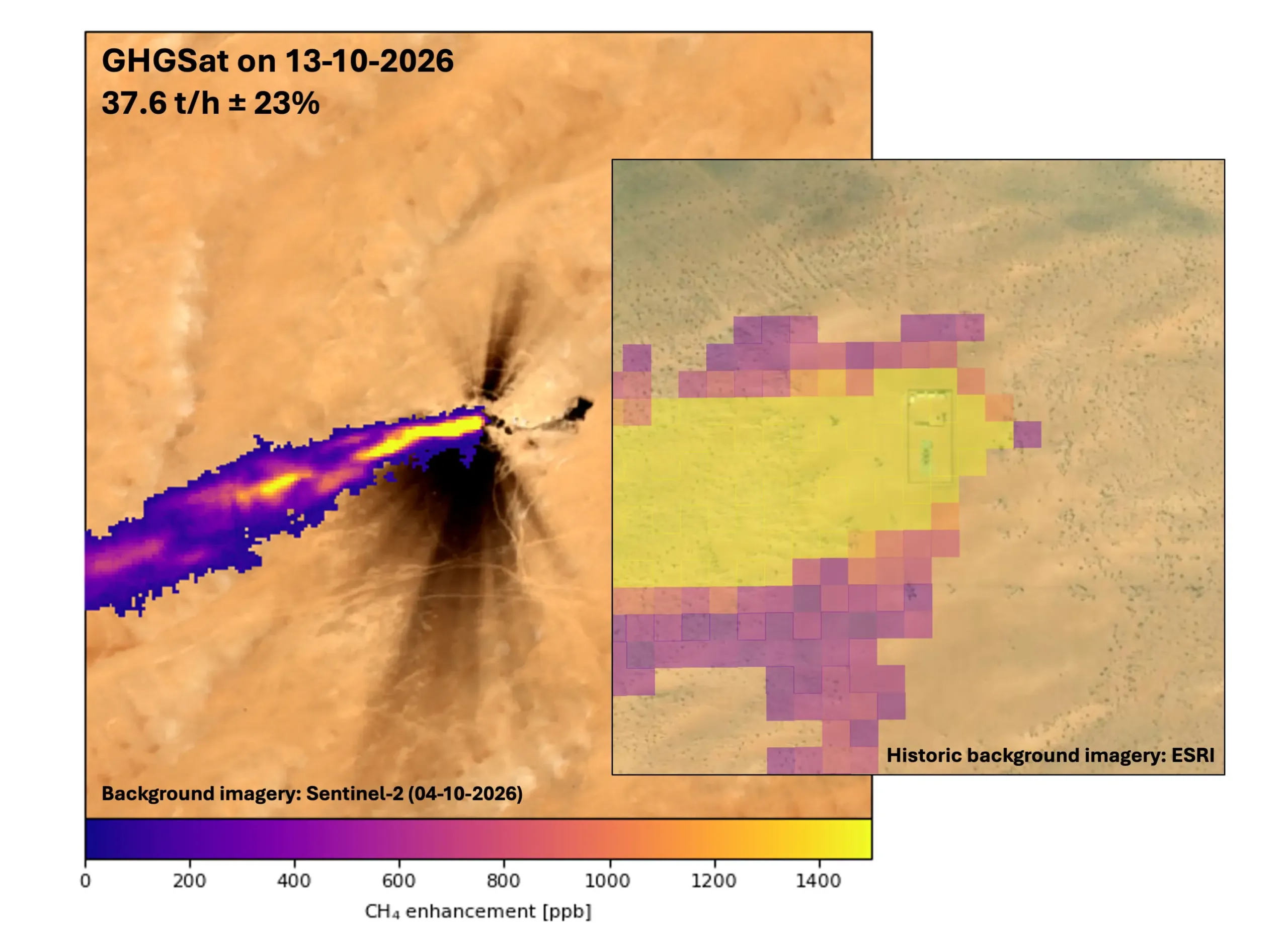
The cooperation also allows Canadian companies to contribute to European services, as a recent case in Niger shows. In October 2026, the Copernicus Atmosphere Monitoring Service (CAMS) followed a large methane leak from an oil well in the Agadem oil fields of eastern Niger. According to the Netherlands Space Research Organisation (SRON), which provides the data for the CAMS Methane Hotspot Explorer, the leak started on 25 September 2026. The Tropospheric Monitoring Instrument (TROPOMI) on Copernicus Sentinel-5P detected the methane plumes over a wide area, and imagery from Sentinel-2 located the facility at their origin.
SRON then requested high-resolution data from Montreal-based GHGSat, one of the Copernicus Contributing Missions, the commercial and national satellite missions which complement the Sentinel satellites. On 13 October 2026, a GHGSat observation at 25 metres resolution estimated an emission rate of 37.6 tonnes of methane per hour, with a margin of error of ±9 tonnes per hour. Earlier detections had indicated more than 40 tonnes per hour, a high rate for an accidental leak. On 23 October, CAMS reported that the leak had been contained, with no methane plumes visible in GHGSat observations from 20 and 21 October. According to CAMS, the case shows the value of combining wide-area Copernicus monitoring with targeted high-resolution data acquisitions. Better detection of large sources of methane, a potent greenhouse gas, helps inform decisions on emissions mitigation.
European data also travel in the other direction, as in Western Canada, where BGC Engineering, an applied Earth sciences company based in Vancouver, uses ERA5-Land, a reconstruction of past weather and land-surface conditions since 1950 produced by the Copernicus Climate Change Service (C3S). Working with pipeline operators, the company combines variables such as precipitation, soil moisture, and snow with about 500 annual landslide displacement measurements to support the proactive management of infrastructure exposed to landslides.
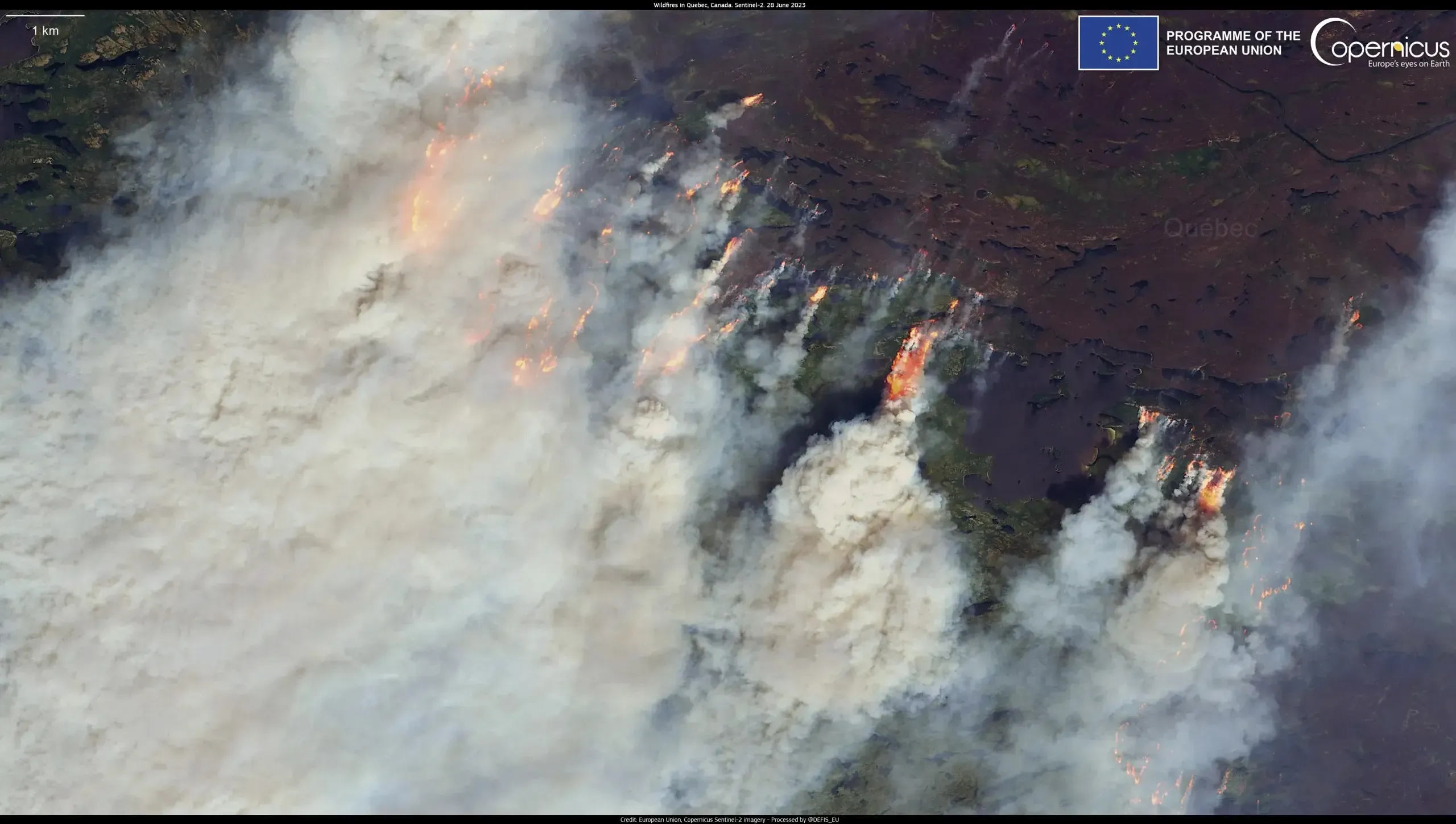
Wildfires are another area of shared concern, as smoke and greenhouse gas emissions spread beyond national borders. The European Forest Fire Information System (EFFIS) monitors fire activity and fire danger in Europe and neighbouring regions, while the Global Wildfire Information System (GWIS) provides global coverage, including over Canada. Both systems provide a basis for exchanging knowledge on wildfire risk. Canada’s planned WildFireSat satellite constellation, will add a further dimension to Canadian wildfire monitoring. Set to launch in 2029, the mission will strengthen the country’s ability to detect and manage wildfires.
Copernicus: Explore Canada and Europe from space
Galileo: European positioning in Canadian hands
Galileo is the EU’s global navigation satellite system, and its High Accuracy Service (HAS) broadcasts free correction signals, which allow users to calculate their position to within 20 cm horizontally and 40 cm vertically, in nominal conditions. Natural Resources Canada has already tested HAS over Canadian stations and assessed the effect of ionospheric activity in Canada’s North. The European Commission and Canada have agreed to strengthen cooperation on positioning, navigation, and timing (PNT) services through an Administrative Arrangement, signed by Andrius Kubilius, European Commissioner for Defence and Space, and Tim Hodgson, Canada’s Minister of Energy and Natural Resources.
Under the Arrangement, the two sides will study the compatibility and performance of Galileo HAS products used in Canada and their possible evolutions. They will also exchange information on the robustness and resilience of the geodetic reference frame, the coordinate system to which positions are tied, including the geodetic supply chain behind it. The Arrangement also foresees possible cooperation on other present or future Galileo services. The Directorate for Space Policy, Satellite Navigation and Earth Observation of the Directorate-General for Defence Industry and Space (DG DEFIS) and Natural Resources Canada will coordinate the work.
Secure connectivity: IRIS² and GOVSATCOM
The Infrastructure for Resilience, Interconnectivity and Security by Satellite (IRIS²) is the EU’s planned multi-orbit constellation for secure communications. The Governmental Satellite Communications (GOVSATCOM) component of the EU Space Programmes pools satellite communication capacity for public authorities. The EU and Canada will work together to strengthen and expand their cooperation on both systems and, with due respect for the relevant institutional processes, start negotiations towards a cooperation framework of mutual benefit.
An Administrative Arrangement on space secure connectivity cooperation would provide a basis for cooperation on secure connectivity, including at industrial level. Under it, a Secure Connectivity Working Group, to be established by the European Commission and the Canadian government, would exchange information on the current status and prospects of IRIS² and GOVSATCOM and on their possible applications. It would also analyse a possible Canadian participation in GOVSATCOM and a possible Canadian component of IRIS².
Looking ahead
For Europeans, the partnership means more data for Copernicus services, a partner for radar observations of the Arctic, opportunities for wider use of Galileo, and a like-minded partner for secure connectivity. For Canada, it means simpler access to Copernicus data and closer cooperation on European positioning and connectivity services for research, industry, and public authorities. Next steps include assessing Galileo HAS performance in Canada under the Arrangement and exploring possible Canadian participation in GOVSATCOM and IRIS² through the proposed Secure Connectivity Working Group. Environmental and security risks do not stop at borders, and by combining their satellites, data, and expertise, the EU and Canada can monitor the planet more completely than either could alone.