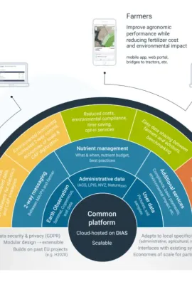
European Union flag
EU Space Policy

Explore EU Space

Results (2151)
Use cases
JELLYX
Earth Observation | Copernicus
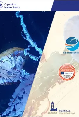
JELLYX: A MONITORING TOOL TO DETECT JELLYFISH SWARMS Pollution, climate change, and marine habitats degradation are affecting ocean-based industries worldwide. Increasing events of jellyfish outbreaks that can reach hundreds of individuals per cubic meter are harmful to marine ecosystems and human health, with severe impacts on fisheries, tourism,
Use cases
Drought Monitoring in Romania
Earth Observation | Copernicus
DROUGHT MONITORING IN ROMANIA In Romania, the complex agricultural drought is a climatic hazard phenomenon inducing the worst consequences in agriculture. The area subjected to desertification, characterized by an arid, semiarid or sub humid-dry climate is around 30% of the total surface of Romania. The operational service offers the monitoring
Use cases
EU Space Data for Sustainable Farming
Earth Observation | Copernicus
Farm Sustainability Tool (FaST) - Space Data for Sustainable Farming The Farm Sustainability Tool (FaST) digital services platform is supported by the European Commission’s DG Agriculture and Rural Development, by the EU’s Space Programme (DG DEFIS) and by the EU’s ISA Programme (DG DIGIT). FaST will help EU farmers, Member State Paying Agencies,
Use cases
Map of relative index of pasture productivity over Europe, comparing February-March 2018 with the historical statistics (1999-2017)
Earth Observation | Copernicus
CROP MONITORING IN EUROPE The European Commission’s Joint Research Centre (JRC) acquires and shares relevant data and develops tools and methods for Monitoring Agriculture ResourceS (MARS), which includes the acquisition and use of remote sensing imagery. The MARS activities support the Common Agriculture Policy (CAP) in Europe and help ensure
Use cases
EGNOS visibility map
Earth Observation | Copernicus
EU-DEM EGNOS visibility map was computed using the Digital Elevation Model over Europe (EU-DEM). The map shows all areas within the Digital Elevation Model over Europe where there is no visibility of one or both EGNOS operational geostationary satellites (PRN 120 and 123). Further information here. Dev. & Cooperation Print to pdf

Showing 2106-2110 of 2151 results