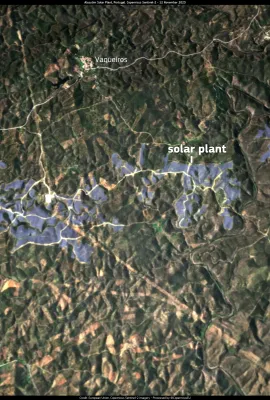
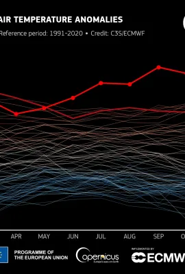
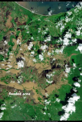
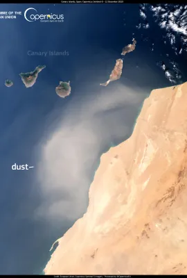
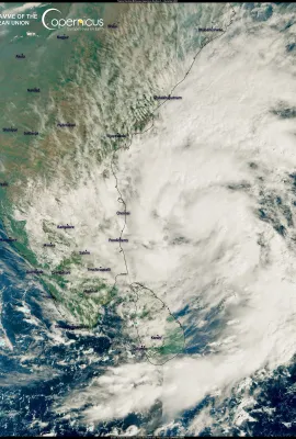
European Union flag
EU Space Policy

Explore EU Space

Results (1080)
Image of the Day
Typhoon Koinu zeroes in on Taiwan
Earth Observation | Copernicus
Koinu, visible in this image acquired by one of the Copernicus Sentinel-3 satellites on 2 October, is a powerful typhoon currently moving north of the Philippines in the Pacific Ocean. Koinu is currently classified as a Category 3 typhoon. It is expected to make landfall in southwestern Taiwan, bringing torrential rain, winds of up to 195 km/h...
Image of the Day
Pinios river
Earth Observation | Copernicus
Storm Elias is the second major storm to hit Greece in just a few weeks. The heavy rains it caused have resulted in the overflowing of rivers and widespread floods in the region of Thessaly. In this image, acquired by one of Copernicus Sentinel-2 satellites, the massive amount of sediment washed away by the floods can be seen as the Pino River...
Image of the Day
Ibernian Peninsula
Earth Observation | Copernicus
The Iberian Peninsula, imaged by one of Copernicus Sentinel-3 satellites on 27 September, is undergoing an unseasonal heat wave. After a particularly hot summer, the high pressure has caused the rise of warm African air from the Sahara, which is also overheated by solar radiation and hardly hindered by the almost total absence of clouds. This...
Image of the Day
Taillon glacier
Earth Observation | Copernicus
Pyrenean glaciers such as the Aneto, Maladeta, Oulettes de Gauve or Tallion glaciers are disappearing due to the consequences of Climate Change. The increase in summer temperatures and the reduction of snowfall have had devastating consequences for these small glaciers, which are recessing at worrying speed. The Institute of Ecology of the...
Image of the Day
Disastrous floods hit South Africa
Earth Observation | Copernicus
In the past few days, heavy rains have caused devastating floods in the Western Cape Region, in South Africa. Eleven casualties have been reported, and thousands of families have been evacuated. The rain has caused rivers to overflow, washing away several roads and disrupting traffic in the area. This image, acquired by one of Copernicus...
Image of the Day
Multiple wildfires burning in Indonesia
Earth Observation | Copernicus
This image, acquired by one of the Copernicus Sentinel-2 satellites on 27 September 2023, shows the smoke clouds caused by the wildfires that are burning the peatlands of the Central and South Kalimantan provinces in Indonesia. The wildfires, which have burned more than 90,000 hectares of peatlands, have been ongoing on the Indonesian part of...
Image of the Day
Svalbard Satellite Station, an important part of the Copernicus Sentinel ground segment
Earth Observation | Copernicus
This image, acquired by one of Copernicus Sentinel-2 satellites on 26 September, shows the Svalbard Satellite Ground Station (SvalSat), located on the island of Spitsbergen in the Norwegian archipelago of Svalbard. It is operated by Norwegian company Kongsberg Satellite Services and was inaugurated as part of the Copernicus Sentinel satellite...
Image of the Day
Louisiana Governor requests Federal Emergency Declaration as saltwater intrusion into Mississippi River threatens water supply
Earth Observation | Copernicus
The drought of the past months is affecting the water flow of the Mississippi River in Louisiana, USA. According to local authorities the river water volume has fallen to historic lows, causing saltwater from the Gulf of Mexico to move upstream. This could impact the quality of the water supply in the area. The Army Corps of Engineers, which is...
Image of the Day
Kuldïga, recently included in the UNESCO World Heritage Sites list
Earth Observation | Copernicus
On 17 September 2023, UNESCO added 40 new World Heritage sites to its list of protected approval.  Among them is Kludïga, visible in this Copernicus Sentinel-2 image acquired on 12 September. Kludïga is a town in western Latvia on the banks of the Aleksupite river. Located in one of the greener countries in Europe, Kludïga is often nicknamed...
Image of the Day
Wildfires continue to spread in Canada
Earth Observation | Copernicus
The wildfire season is still ongoing in British Columbia and Alberta, leading to many evacuations. In Chateh, the wildfires are getting closer to the community, forcing residents to leave their homes.  The wildfire’s smoke is heavily affecting the air quality in many Canadian Arctic areas. In this image, acquired by the Copernicus Sentinel-3...
Image of the Day
Sicily still under wildfire emergency
Earth Observation | Copernicus
This image of the Italian island of Sicily, acquired by one of the Copernicus Sentinel-3 satellites on 22 September at 09:20 UTC, shows the hotspots and the enormous smoke cloud generated by a wildfire burning in the Madonie Regional Park  near the city of Cefalù. On that day, more than 40 wildfires were burning simultaneously. The fire crisis...
Image of the Day
Snow Shortage Shuts Down French Alps Resort
Earth Observation | Copernicus
The winter sports industry is vulnerable to the effects of climate change, and Europe is beginning to feel its first impacts.  This image, acquired by one of the Copernicus Sentinel-2 satellites on 1 September, shows La Sambuy, a ski resort in the French Alps. For the first time in seventy years, the resort will not reopen for the 2024 winter...
Image of the Day
Agricultural areas around Thessaly, Greece, remain flooded
Earth Observation | Copernicus
Storm Daniel and the consequent floods caused damage to over 700 km2 in Greece's central agricultural belt. The dry soil has impeded the absorption of floodwaters, leaving some areas still submerged in several centimetres of water. This Copernicus Sentinel-2 satellite image, acquired on 20 September 2023, shows remaining agricultural areas...
Image of the Day
Hurricane Nigel in the Atlantic Ocean
Earth Observation | Copernicus
This image, acquired on 19 September by one of the Copernicus Sentinel-3 satellites at 13:52:02 UTC, shows Hurricane Nigel. Nigel is the sixth storm of the Atlantic hurricane season. It formed on 16 September, and is currently located at approximately 1,000 km SE of Bermuda. It is classified as a Category 1 hurricane, but according to the US...
Image of the Day
Climate change puts World Heritage Sites at risk
Earth Observation | Copernicus
Climate change poses a threat to World Heritage Sites, endangering their integrity and unique beauty. This image, acquired on 15 September 2023 by one of the Copernicus Sentinel-2 satellites, shows the Sanssouci Palace and Gardens in Potsdam, a 300-year-old World Heritage site in Germany. During the past years, this historic jewel has been hit...
Image of the Day
Unprecedented emissions from 2023 Canadian wildfires
Earth Observation | Copernicus
The wildfire season is far from over in Canada, with severe wildfires still active in various provinces, such as Alberta and British Columbia. This image, acquired on 16 September 2023, shows the massive smoke plume emitted by the fires ongoing in Alberta, engulfing the skies of the Arctic Circle.  Since May 2023, 17.3 million hectares of land...
Image of the Day
Downgraded post-tropical cyclone Lee reaches Canada
Earth Observation | Copernicus
Once classified as a category 5 Hurricane, Lee has weakened and transformed into a “post-tropical cyclone”, impacting the Nova Scotia region after passing through New England and eastern Canada. Winds of up to 112 km/h have been reported, along with heavy rainfall that has led to coastal road flooding and power outages in many areas. On 16...
Image of the Day
Wine production in Italy is at risk
Earth Observation | Copernicus
Heavy spring rain, followed by drought and the development of fungus on vine leaves, could potentially lead to a 12% loss in this season's grape harvest in central Italy, as reported by UIV, Assoenologi , and the ISMEA agriculture institute.  Grape downy mildew, a condition caused by the “plasmopara viticola” fungus, is impacting the grapes,...
Image of the Day
Severe floods devastate Derna in Libya
Earth Observation | Copernicus
On 10 September 2023, heavy rains caused by Storm Daniel’s flooded many cities in eastern Libya, the city of Derna being the worst hit. More than 30,000 people have been displaced after the flooding in Derna, and 5,100 casualties are reported to date. The Copernicus Emergency Management Service (CEMS) Rapid Mapping module has been activated...
Image of the Day
“Ocean Explorer” cruise ship aground in Greenland
Earth Observation | Copernicus
On 11 September, the Norwegian Ocean Explorer cruise ship ran aground in a remote fjord of the Northeast Greenland National Park. With 200 passengers on board, it is awaiting a rescue that will take several days since the nearest vessel capable of helping is approximately 2,000 km away. Local Authorities have confirmed that all passengers are...

Showing 821-840 of 1080 results