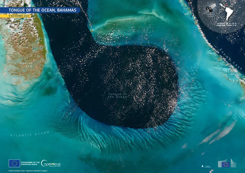
European Union flag
EU Space Policy

Explore EU Space

Results (1080)
Image of the Day
Ahe Atoll, French Polynesia
Earth Observation | Copernicus
Ahe Atoll, located in the Tuamotu Archipelago of French Polynesia in the central Pacific Ocean, is part of a vast chain of coral atolls known for lagoon-based pearl cultivation.
Image of the Day
Forest Fires in Europe, Middle East and North Africa, 2025
Earth Observation | Copernicus
The recently published Forest Fires in Europe, the Middle East and North Africa 2025 Advanced Report, produced by the Joint Research Centre (JRC) and based on data from the European Forest Fire Information System (EFFIS), indicates that in 2025 a total burnt area of 2,242,195 hectares has been recorded.
Image of the Day
Dust storm across the Algeria-Mali border
Earth Observation | Copernicus
On 30 March 2026, a major dust storm formed in the south of Algeria, disrupting trans-Saharan transport routes and affecting air quality across West and North Africa.
Image of the Day
Transboundary haze over the Mekong Region
Earth Observation | Copernicus
During the dry season, the Mekong Region, encompassing parts of northern Thailand, eastern Myanmar, and Laos, is affected by an increase in fire activity.
Image of the Day
Sargassum along the coasts of Panama
Earth Observation | Copernicus
Sargassum blooms are affecting the Caribbean coastline, and experts and environmental authorities predict that 2026 will be among the worst years on record.
Image of the Day
Spring Thaw in southern Finland
Earth Observation | Copernicus
Southern Finland's landscape is defined by an intricate network of forests, lakes, and low-lying coastal areas shaped by ancient glaciers.
Image of the Day
Mount Elgon National Park, Uganda and Kenya
Earth Observation | Copernicus
Mount Elgon National Park, a protected area shared by Uganda and Kenya, safeguards one of East Africa’s oldest and largest volcanic mountains.
Image of the Day
Nordic landscapes: Oslo, Norway and Iceland
Earth Observation | Copernicus
Oslo, the capital of Norway, and Iceland, located in the North Atlantic Ocean, illustrate contrasting yet interconnected Nordic environments shaped by climate and geology.
Image of the Day
Læsø island, Denmark
Earth Observation | Copernicus
Læsø, a low-lying Danish island in the Kattegat Strait, is a Natura 2000 protected area, recognised for its unique coastal habitats and dynamic geomorphology.
Image of the Day
Tasman Glacier, New Zealand
Earth Observation | Copernicus
21 March 2026 marks World Day for Glaciers, which is dedicated to raising global awareness of the importance of glaciers and the urgent need to protect them.
Image of the Day
Tropical Cyclone Narelle, Australia
Earth Observation | Copernicus
Tropical Cyclone Narelle formed on 16 March 2026 in the Coral Sea, off the coast of Queensland, Australia.
Image of the Day
Recent eruption of Piton de la Fournaise
Earth Observation | Copernicus
Piton de la Fournaise, one of the most active volcanoes on Earth, dominates the south-eastern part of Réunion Island, a French territory in the Indian Ocean.
Image of the Day
Asset Map of Munich, Germany
Earth Observation | Copernicus
Understanding where economic value is concentrated in a landscape is essential for assessing the potential economic losses caused by disasters, and for managing risks efficiently.

Showing 1-20 of 1080 results