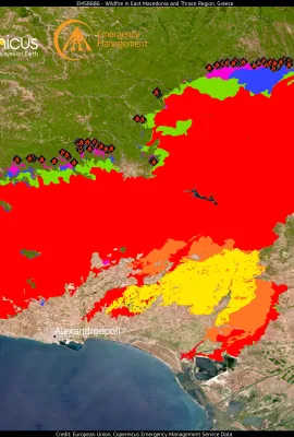
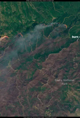
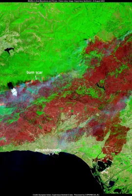
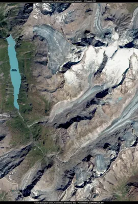
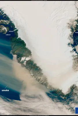
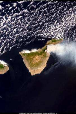
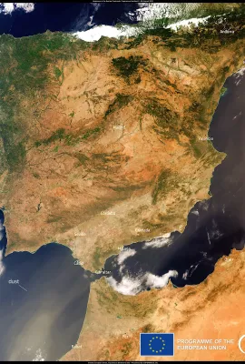
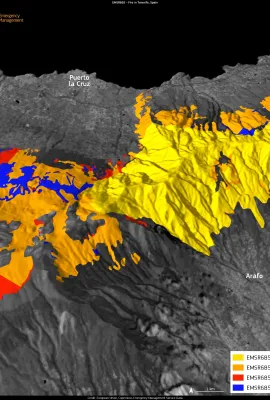
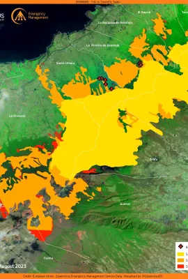
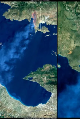
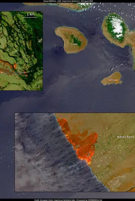
This image, acquired by one of Copernicus Sentinel-3 satellites on 22 June 2023, shows the massive smoke cloud produced by the multiple wildfires ongoing in Québec engulfing the sky of North America. Several communities in this Canadian province have been advised to prepare for evacuations, as the province’s forests Minister warned that...
Results (1080)
This image, captured by one of Copernicus Sentinel-2 satellites on 19 June, shows the snow-capped peaks of the Caleta Tortel Coastal Marine Protected Area in Chilean Patagonia. Tortel is surrounded by breathtaking landscapes characterised by glaciers, mountains, dense forests and fjords where meltwater, river water and seawater combine. The...
This image, acquired by one of the Copernicus Sentinel-3 satellites on 20 June 2023, shows plumes of Saharan dust reaching Western Italy as the first summer heatwave hits the country. The dust will affect most of the peninsula, causing skies to appear yellowish or milky. The Copernicus Atmosphere Monitoring Service (CAMS) tracks all stages of...
These images, acquired by Copernicus Sentinel-2 satellites from June 2020 to June 2023, show the progressive draining of the Fuente de Piedra wetlands. Once a flourishing nesting site for flamingos, the lagoon now hosts only a few dozen adult birds, as many have been compelled to seek new nesting grounds due to the ongoing drought. According to...
This image, acquired by one of the Copernicus Sentinel-2 satellites, shows the Icelandic town of Egilsstaðir, where on 17 June 2023 temperatures reached 27.9°C. This exceptional value was the highest ever recorded in the country before the summer solstice. It is also noteworthy to mention that the Icelandic all-time record is 30.5°C. ...
This image, acquired by one of the Copernicus Sentinel-2 satellites on 6 June 2023, shows the coastal town of Point Lay in Alaska, USA. The permafrost on the Arctic coast of Alaska is thawing so fast that it is destroying buildings and infrastructure in Point Lay. The soil here is largely made up of a mixture of organic material, sediment, and...
This image, acquired by one of the Copernicus Sentinel-2 satellites on 10 June 2023, shows the Marceddì Lagoon, a Natura 2000 site in Sardegna, Italy. The Lagoon, which is a Mediterranean ecological paradise, is in danger, as significant parts of the area could be submerged by 2100 due to climate change. To protect this biodiverse haven, the...
This image, acquired by one of Copernicus’ Sentinel-3 satellites, shows plumes from the Québec wildfires making their way to north-eastern Europe. Canada, which is currently affected by around 450 active fires, has activated the EU Civil Protection Mechanism requesting European assistance. In an immediate response, France, Portugal and Spain...
This image, acquired by the Copernicus Sentinel-1A satellite, shows Windpark Fryslân, the largest freshwater wind farm in the world. The wind turbines were installed in the Lake IJssel in the Netherlands, and they started running at the end of 2021. Fryslân has a total power capacity of 382.7 MW. It consists of 89 wind turbines, each with a...
This image, acquired by one of Copernicus’ Sentinel-3 satellites, shows Cyclone Biparjoy, which is expected to make landfall in India’s Gujarat state. As the cyclone gathers strength, emergency measures are being promptly implemented. In India, local authorities organised the evacuation of thousands of residents of the coastal areas deemed...
This image, acquired on 29 May by one of the Copernicus Sentinel-2 satellites, shows Tallinn’s 14-kilometre pollinator highway. The linear park serves as a green corridor connecting different areas of the city, facilitating walking and biking for residents, as well as a pathway for pollinators such as butterflies, bumblebees, bees and other...
According to the Copernicus Emergency Management Service’s European Drought Observatory, 26.9% of the EU territory is in 'Warning' conditions. Northern European countries, known for their generally cool and damp climates, are also suffering from drought conditions, with Sweden seeing the most severe effects. This image, acquired by one of...
This image, retrieved from Copernicus Climate Change Service data, shows the surface air temperature anomaly for May 2023. It provides an indication of deviations from the long-term average temperatures for this period. The analysis reveals significant regional variations across different parts of the globe, reflecting the complex interplay of...
This image, acquired by one of Copernicus Sentinel-2 satellites, shows the Mayotte archipelago. The main island is suffering from an ongoing water scarcity problem which stems primarily from an extended period of drought that has severely depleted the island’s freshwater reserves. The region's reliance on rainwater and limited alternative...
This image, acquired on 7 June 2023 by a Copernicus Sentinel-3 satellite, shows plumes from the Canadian fires reaching the American East Coast. In a region-spanning event, New York City found itself shrouded in thick smoke while Philadelphia and Washington DC declared a 'code red' emergency. New York City's iconic skyline became obscured,...
This image, acquired by one of the Copernicus Sentinel-2 satellites on 18 May 2023, shows the city of Stockholm in Sweden. Today we are celebrating the 25th anniversary of Copernicus, the EU’s Earth Observation flagship programme. With an impressive fleet of seven satellites deployed in space, along with contributions from various missions, in...
In the town of Rust, visible in this image acquired by one of the Copernicus Sentinel-2 satellites, wine growers have been experimenting with new grape varieties that are better suited to the changing climate. This innovation is a response to the rising temperatures and shifting weather patterns that have created difficulties for the...
This image, captured by one of the Copernicus Sentinel-3 satellites on 4 June 2023, shows phytoplankton blooms painting vibrant streaks off the coasts of France and Britain. These tiny powerhouses silently run the Earth's ecosystems, producing about half of the world’s oxygen. They serve as the foundation of the marine food web and support...
Extensive forest fires in Québec's North Shore region have caused the displacement of thousands of residents. The relentless fires, driven by dry weather conditions and strong winds, have posed a severe threat to numerous communities in the region. The displaced residents are grappling with the uncertainty over when they will be able to return...
Múlajökull is one of the glacial tongues that extends off the southeast portion of the of the Hofsjökull glacier system, the third largest in Iceland, located in the central highlands. Glacial tongues are long, narrow extensions of ice that flow down valleys or through mountain passes from larger ice caps or glaciers. The ice margin of the...
Showing 921-940 of 1080 results