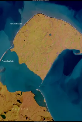
This image, acquired by one of Copernicus Sentinel-2 satellites on 2 September 2024, shows the Arctic coastline of Canada’s Yukon territory, where land meets the dynamic waters of the Beaufort Sea. In the image, Herschel Island (Qikiqtaruk), Avadlek Spit, and the Firth River delta are visible, all of which are affected by coastal and riverine...
Results (2166)
This image, acquired by one of the Copernicus Sentinel-2 satellites on 5 November 2024, shows the Vipava Valley in southwestern Slovenia. Known for its mild Mediterranean climate, fertile lands, and strong winds, the valley is an important agricultural region, particularly for vineyards and fruit production. The Vipava River, which meanders...
This image, acquired by one of the Copernicus Sentinel-2 satellites on 5 March 2025, shows Mount Teide in Tenerife, Canary Islands, Spain, covered in fresh snow. Following a weekend of heavy rain and sub-zero temperatures brought by a storm system, officially known as an upper-level isolated depression (DANA), snowfall began on 2 March 2025....
How will snow loads change in the future? The FPCUP SNOWLOADS C3S app prototype provides data on present and future snow loads, helping users prepare for the future.
Valais is a canton in southwestern Switzerland, bordering Italy to the south. Home to some of the highest peaks in the Swiss Alps, including the famous Matterhorn, its stunning alpine landscapes and ski resorts make it a popular tourist destination. The canton is also the country’s main wine-producing region. Valais includes the valley of the...
Showing 591-595 of 2166 results