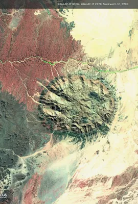
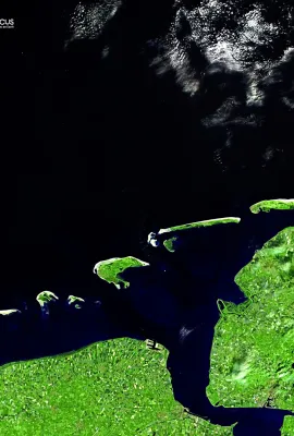
The Dutch West Frisian and the German East Frisian Islands are barrier islands. Barrier islands form as waves repeatedly deposit sediment parallel to the shoreline. As wind and waves shift according to weather patterns and local geographic features, these islands constantly ‘’move’’, erode, and grow. This image of the West and East Frisian...
Results (2165)
So, what is a glacier? A glacier is made up of fallen snow that has been compressed into a large, thickened ice mass over many thousands of years. Captured on July 21, 2024, this glacier image shows the power of true colour Sentinel-2 imagery for evaluating cryosphere patterns. Slight highlight compression was applied to avoid the...
Namibia’s highest mountain the Brandberg Mountain Range is situated in the Erongo region in the western part of Namibia, ninety kilometres from the Atlantic Ocean, and covers an area of 760 square kilometres. The Range gets its name from an almost black appearance and the bright colours that the setting sun paints onto the mountains as if the...
Large fires have been reported in Bulgaria as an extreme heatwave has been sweeping the southern Balkans over the past few days. On July 18, 2024, Copernicus Senitnel-2 captured an image of the Stara Zagora region showing the burn scars the blaze left behind. We can still observe the fire burning near Bolyarovo. Earlier yesterday, the...
The information provided by the Copernicus Atmosphere Monitoring Service (CAMS) is critically important to a wide range of users across Europe and the rest of the world. CAMS data on air pollution and health, solar energy, greenhouse gases, and climate forcing are made even more reliable through a range of evaluation processes. These are based...
Showing 891-895 of 2165 results