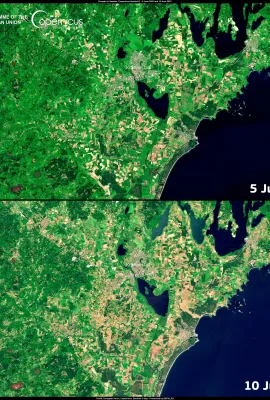
This image, acquired on 29 May by one of the Copernicus Sentinel-2 satellites, shows Tallinn’s 14-kilometre pollinator highway. The linear park serves as a green corridor connecting different areas of the city, facilitating walking and biking for residents, as well as a pathway for pollinators such as butterflies, bumblebees, bees and other...
Results (2163)
According to the Copernicus Emergency Management Service’s European Drought Observatory, 26.9% of the EU territory is in 'Warning' conditions. Northern European countries, known for their generally cool and damp climates, are also suffering from drought conditions, with Sweden seeing the most severe effects. This image, acquired by one of...
This image, retrieved from Copernicus Climate Change Service data, shows the surface air temperature anomaly for May 2023. It provides an indication of deviations from the long-term average temperatures for this period. The analysis reveals significant regional variations across different parts of the globe, reflecting the complex interplay of...
This image, acquired by one of Copernicus Sentinel-2 satellites, shows the Mayotte archipelago. The main island is suffering from an ongoing water scarcity problem which stems primarily from an extended period of drought that has severely depleted the island’s freshwater reserves. The region's reliance on rainwater and limited alternative...
This image, acquired on 7 June 2023 by a Copernicus Sentinel-3 satellite, shows plumes from the Canadian fires reaching the American East Coast. In a region-spanning event, New York City found itself shrouded in thick smoke while Philadelphia and Washington DC declared a 'code red' emergency. New York City's iconic skyline became obscured,...
Showing 1431-1435 of 2163 results