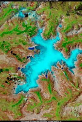
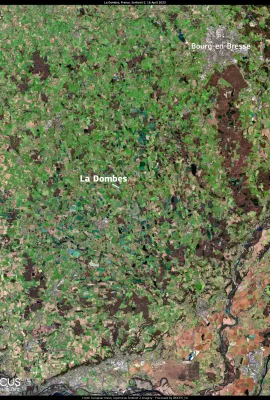
This image, acquired by one of the Copernicus Sentinel-2 satellites on 16 April 2023, reveals the stunning landscape of the Dombes area in central France. Dombes has been recently designated as a Ramsar wetland of international importance. With over 1,200 rain-water pools, the Dombes is one of the main inland fish farming territories in France...
Results (2162)
DLR | Online | English
The Quelccaya glacier in the Andes of Peru can be seen in this image, captured on 30 November 2022 by one of the Copernicus Sentinel-2 satellites. The Quelccaya glacier, which was once the world's largest tropical ice cap, has been reduced its volume by nearly 50% over the past four decades and is rapidly melting at a rate of about 5% per year...
Drought continues to grip Spain. One of the most affected areas is Andalusia, particularly in the area of the Guadalquivir River Basin. The reservoirs in the basin are currently at a low capacity of 25.5%, which is 36.5% below the average of the last 25 years. This has resulted from consecutive years of high temperatures and low rainfall, which...
This image, acquired on 19 April by one of the Copernicus Sentinel-2 satellites, depicts Lake Saint Clair, one of the Great Lakes of North America. During the winter months, the lake's climate is shaped by cold air masses from the Article Circle, resulting in the formation of sea ice in the lake's waters and heavy snowfall in surrounding...
Showing 1496-1500 of 2162 results