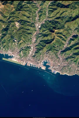
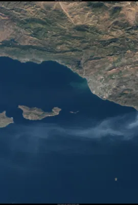
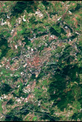
Ecuador is in the midst of its worst drought in more than 60 years. The ongoing crisis has dropped water reserves to critical levels, impacting electricity service in a country which relies on hydroelectric plants for seventy percent of its electricity supply. Ecuador’s president has announced a plan to add 1,598 megawatts of capacity to the...
Results (1081)
Protected Areas (MPAs) are increasingly seen as essential for preserving marine biodiversity while supporting local communities. These legally protected zones, which span oceans, estuaries, and lakes, are key to safeguarding vulnerable ecosystems and species. Portugal has recently created Europe’s largest MPA network, providing important...
After being impacted by torrential rainfall and subsequent flooding from Storm Boris in September 2024, on 19 October the Italian region of Emilia-Romagna has been affected by another severe episode of flooding after days of heavy rainfall. Several rivers in the region have reached critical levels, with many others overflowing. At least 3,000...
The islands of Macaronesia are becoming increasingly vulnerable to extreme coastal flooding caused by powerful Atlantic storms. As climate change exacerbates these challenges, the European Commission’s LIFE Garachico project is supporting local communities in strengthening the region’s resilience to flooding and storm surges. One of the...
Located on the border between Zambia and Zimbabwe, Lake Kariba is the largest man-made lake in the world. It is home to the essential Kariba Dam, which provides over 80% of Zambia's national electricity supply. However, recent effects of El Niño and rising temperatures have intensified drought conditions in the region, threatening the...
The Galápagos Islands of Ecuador, known for their unique and robust biodiversity, face increasing threats from climate change. Rising ocean temperatures have impacted local wildlife, making it more difficult for species such as marine iguanas and sea turtles to find food and nest. While temperatures in the Galápagos naturally fluctuate with the...
With a rising water level of 3.4 millimetres annually, the islands of the Panamanian archipelago of San Blas are at high risk of being submerged, and researchers predict that they will be uninhabitable by the end of the century. The rising sea levels are impacting both residents and tourists. In the past year, some of the Guna people of the San...
On 9 October 2024, Hurricane Milton struck the western coast of Florida, USA, bringing tornadoes, extreme wind, and torrential rainfall to the region. Milton was the third-fastest intensifying Atlantic hurricane on record, strengthening to a Category 5 storm in under 24 hours before decreasing to a Category 3 storm before making landfall. A...
This Copernicus Sentinel-2 image, acquired on 15 October 2024, shows an ongoing algal bloom in Lake Pyramid, Nevada, USA. Algal blooms can be harmful to both humans and animals, and can also impact local tourism, fishing, and recreational activities. In Lake Pyramid, these blooms occur almost every year, driven by a combination of nutrient...
A new study suggests that coastal historical sites in Greece are at risk of being submerged by the end of the century due to rising sea levels driven by global warming. The researchers created flood risk maps based on local and global predictions to assess 464 historical sites along the Eastern Mediterranean coast, finding that 147 of these...
The major rivers of the Amazon Basin are currently at critical levels. As a main tributary of the Amazon River, the Rio Negro drains about 10% of the Basin, and has reached the lowest levels in the last 122 years, surpassing the record low set later in the 2023 dry season. According to the Brazilian Geological Service, this marks the worst...
The Copernicus Marine Service (CMEMS) published the EU Copernicus Ocean State Report (OSR 8) on 30 September 2024, an annual publication which provides information on the current conditions and changes in European and global bodies of water. A key finding of the report is that there has been a loss of nearly 2.2 million km² of Arctic sea ice...
This Copernicus Sentinel-2 image, acquired on 19 July 2024, shows Réunion Island, a French department located between Madagascar and Mauritius in the southwest Indian Ocean. Known for its lush rainforests, volcanic mountains, and beautiful beaches, not only the island’s stunning landscapes but also its weather makes it popular with...
On 9 October 2024, Hurricane Milton made landfall in Florida as a Category 3 storm, impacting a region still reeling from the devastation caused by Hurricane Helene just weeks earlier, which resulted in widespread destruction and hundreds of fatalities. Milton unleashed tornadoes and winds exceeding 160 kilometres per hour, leaving more than...
Aquaculture is an important contributor to the global food supply, as well as one of the fastest growing food production sectors in the world. In Europe, the European Commission supports a sustainable aquaculture sector which ensures the supply of nutritious, healthy and tasty food with a low environmental and climate footprint. This...
The Copernicus Climate Change Service (C3S) has published its latest monthly Climate Bulletin, highlighting significant climate trends. September 2024 marked the second-warmest September on record, following September 2023, with temperatures 0.73°C above the average for that month from 1991 to 2020. Additionally, it was 1.54°C warmer than the...
In the face of natural or man-made disasters, the Copernicus Emergency Management Service (CEMS) provides On-Demand Mapping services leveraging satellite imagery and other geospatial data. This information is key to supporting response and recovery efforts around the globe, particularly regarding floods, earthquakes, landslides, hurricanes,...
Located on Ireland’s east coast, Dundalk Bay is a Natura 2000 site, recognised for its importance to an impressive range of marine and coastal species. It is protected under the European Birds Directive due to its role as a habitat for wintering waterbirds and migratory species. The bay's mudflats, sandflats, and estuarine ecosystems support...
This Copernicus Sentinel-3 image from 3 October 2024 shows Hurricane Kirk when it was about 2,000 km southwest of the Azores Archipelago. On the same day on which the image was acquired, Kirk swelled to a Category 4 storm in the central Atlantic Ocean as it made its way northeast, skirting the Caribbean islands and the eastern coast of the...
A recent analysis of the UNESCO World Heritage Sites threatened by climate change suggests that 17 of the 50 most at-risk sites are located on European territory. While flooding and drought were the leading potential hazards to the landmarks, coastal erosion, landslides, extreme temperatures, and storms could also pose threats to these...
Showing 501-520 of 1081 results