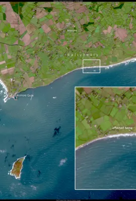
European Union flag
EU Space Policy

Explore EU Space

Results (1081)
Image of the Day
Phytoplankton Bloom in the Barents Sea
Earth Observation | Copernicus
Phytoplankton, tiny photosynthetic organisms, are the base of the marine food chain. Their blooms play a vital role in marine ecosystems and in the regulation of global climate, as they are responsible for a significant proportion of the Earth's oxygen production and contribute to the sequestration of atmospheric carbon.  This image, acquired...
Image of the Day
Lake Constance
Earth Observation | Copernicus
Lake Constance, visible in this Copernicus Sentinel-2 image acquired on 29 July 2024, lies on the border between Germany, Austria and Switzerland and is one of the most important natural treasures in Central Europe. Covering an area of almost 540 square kilometres, the lake is not only an important source of fresh water, but also a hotspot of...
Image of the Day
The Mer de Glace Glacier in the Alps
Earth Observation | Copernicus
The Alpine Arc is among the regions most threatened by climate change. Over the past two decades, the glaciers of this iconic mountain range in the heart of Europe have lost about a third of their ice volume, receding by an average of 30 metres per year and thinning by 1 to 1.5 metres annually across their entire surface. One of the most...
Image of the Day
Severe Drought in Costa Blanca, Spain
Earth Observation | Copernicus
This Copernicus Sentinel-2 image acquired on 17 August 2024 shows the Costa Blanca, an area severely affected by the drought in Spain. The prolonged lack of rainfall has led to significant water shortages, resulting in the salinisation of aquifers in coastal towns such as Teulada-Moraira and Benitatxell. As a result, tap water has been declared...
Image of the Day
Severe floods in Pakistan
Earth Observation | Copernicus
This image, acquired by one of the Copernicus Sentinel-2 satellites on 20 August 2024, shows severe flooding caused by the overflowing of the Indus River south of Kandhkot, a small town in Pakistan's Sindh province.Heavy monsoon rains have caused widespread flooding across the country, leading to significant devastation. Local authorities have...
Image of the Day
The Stung Treng Province in Cambodia
Earth Observation | Copernicus
Stung Treng is a province in northeastern Cambodia, renowned for its rich biodiversity and extensive forests. The area is home to a variety of ecosystems, including dense rainforest, rivers, and wetlands, which support a wide range of plant and animal species. The area is particularly important for its role in preserving endangered species and...
Image of the Day
Smoke from Canadian wildfires reaches Western Europe
Earth Observation | Copernicus
For weeks, wildfires in northern Canada have been spewing vast amounts of smoke which has travelled thousands of kilometres across the Atlantic Ocean, darkening the skies of Western Europe. The plume first reached the British Isles and then continued south-eastwards. This true-colour image, acquired by the Copernicus Sentinel-3B satellite at...
Image of the Day
Forest fire in Madeira
Earth Observation | Copernicus
This image, acquired on 18 August 2024 by one of the Copernicus Sentinel-3 satellites, shows a plume of smoke 130 km long rising from the Portuguese island of Madeira as a result of a large forest fire which started on 15 August. The fire began in the Serra de Água area of Ribeira Brava and quickly spread to Câmara de Lobos, where it continues...
Image of the Day
El Hierro's Mar de las Calmas set to become the first marine national park in Spain
Earth Observation | Copernicus
This image, acquired on 26 July 2024 by one of the Copernicus Sentinel-2 satellites, shows the island of El Hierro.  El Hierro is the smallest of the Canary Islands (Spain). It is known for its rich biodiversity and unique marine ecosystems.  Recently, local authorities approved the first proposal to designate Mar de las Calmas, an area south...
Image of the Day
Typhoon Ampil
Earth Observation | Copernicus
This image, acquired by the Copernicus Sentinel-2 satellite on 16 August 2024, shows the eye of Ampil, a typhoon which formed in the Pacific Ocean earlier that month. The storm rapidly intensified, bringing heavy rain and winds to Japan's Izu Islands and to coastal areas of the Kanto and Tohoku regions between 10 and 12 August. With an...
Image of the Day
Kourou in French Guiana
Earth Observation | Copernicus
Ahead of the upcoming launch of the Copernicus Sentinel-2C, we take a closer look at Kourou, the headquarters of the Guiana Space Centre.  Kourou is a coastal town in north-central French Guiana, an overseas department of France. It lies at the mouth of the Kourou River, where its waters flow into the Atlantic Ocean after a journey of 144 km...
Image of the Day
Low water levels impact Danube navigation in Romania
Earth Observation | Copernicus
The Danube River has been affected by significantly reduced water levels, coinciding with the prolonged heat wave impacting Eastern Europe. Recent measurements show that the river's level in Romania is 6 cm below the normal range, with a flow of only 2,900 cubic metres of water per second, far below the August average of 4,600 cubic metres per...
Image of the Day
Major wildfire rages out of control on the fringes of Athens, Greece
Earth Observation | Copernicus
On 11 August, a large wildfire burned out of control in Attica, Greece. The fire has affected at least 10,000 hectares and forced thousands of people to flee their homes.  This Copernicus Sentinel-2 image, acquired on 12 August at 09:05 UTC (12:05 Greek local time), shows the ongoing blaze a few kilometres from the centre of Athens. It combines...
Image of the Day
Record ice cap melting in the Svalbard Archipelago
Earth Observation | Copernicus
During the summer of 2024, the Svalbard Archipelago (in Arctic Norway) is confronted with a new record episode of ice sheet melting.  According to the Laboratory of Climatology and Topoclimatology at the University of Liège, in early August, snow and ice melting on the surface of the Svalbard ice caps reached the highest levels ever recorded,...
Image of the Day
Phytoplankton bloom in the northern Adriatic Sea
Earth Observation | Copernicus
Over the past few weeks, a phytoplankton bloom has been observed in the northern Adriatic Sea.  High temperatures and freshwater inputs from recent heavy rainfall have favoured the bloom. The freshwater input has reduced the sea surface salinity, creating an ideal environment for the rapid proliferation of phytoplankton. Rising temperatures...
Image of the Day
July 2024, the second warmest July on record
Earth Observation | Copernicus
The Copernicus Climate Change Service (C3S) has recently released its latest monthly Climate Bulletin, which highlights that July 2024 was the second warmest July on record globally. Air temperatures reached 16.91°C, 0.68°C above the 1991-2020 average for July, and only 0.04°C lower than the previous high set in July 2023.      This data...
Image of the Day
Canada gripped by heatwave and wildfires
Earth Observation | Copernicus
On 7 August 2024, Canada has been affected by an intense heatwave and several wildfires. The temperature in Inuvik, an Arctic town located less than 100 km from the Arctic Ocean, reached a record high of 34.8°C.  At the same time, several wildfires were ongoing in the region. According to the Department of Environment and Natural Resources of...
Image of the Day
The prolonged drought in Morocco
Earth Observation | Copernicus
The prolonged drought in Morocco is causing serious problems for the agricultural sector. Local Authorities predict that the 2024 wheat harvest will be reduced by almost 50 per cent. This image, acquired by one of the Copernicus Sentinel-2 satellites on 3 August 2024, shows the province of Sidi Kacem, once the heart of cereal production in...
Image of the Day
Biomass burning in Brazil
Earth Observation | Copernicus
Biomass burning is common in South America at this time of year. In the summer of 2024, the phenomenon was particularly intense, with the number of fires rising to a record high for the month of July, one of the highest in 20 years. This Copernicus Sentinel-3 image, acquired on 30 July 2024, shows a large plume of smoke in the state of...
Image of the Day
Zongo Glacier, Bolivia
Earth Observation | Copernicus
The Zongo glacier is located in the Huayna Potosi massif in Bolivia. The glacier is 3 km long and has a surface area of 2.4 km2 This is a 3D rendering of an image acquired by Sentinel-2 on July 31, 2024. Copernicus data and services allow the monitoring of glaciers around the world.

Showing 561-580 of 1081 results