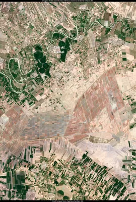
European Union flag
EU Space Policy

Explore EU Space

Results (1173)
Image of the Day
Low water levels impact Danube navigation in Romania
Earth Observation | Copernicus
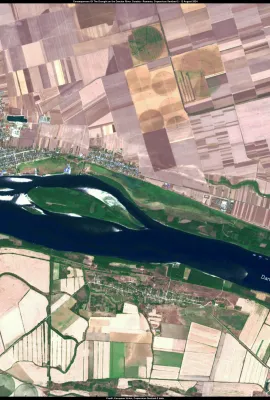
The Danube River has been affected by significantly reduced water levels, coinciding with the prolonged heat wave impacting Eastern Europe. Recent measurements show that the river's level in Romania is 6 cm below the normal range, with a flow of only 2,900 cubic metres of water per second, far below the August average of 4,600 cubic metres per...
Image of the Day
Major wildfire rages out of control on the fringes of Athens, Greece
Earth Observation | Copernicus
On 11 August, a large wildfire burned out of control in Attica, Greece. The fire has affected at least 10,000 hectares and forced thousands of people to flee their homes.  This Copernicus Sentinel-2 image, acquired on 12 August at 09:05 UTC (12:05 Greek local time), shows the ongoing blaze a few kilometres from the centre of Athens. It combines...
Image of the Day
Record ice cap melting in the Svalbard Archipelago
Earth Observation | Copernicus
During the summer of 2024, the Svalbard Archipelago (in Arctic Norway) is confronted with a new record episode of ice sheet melting.  According to the Laboratory of Climatology and Topoclimatology at the University of Liège, in early August, snow and ice melting on the surface of the Svalbard ice caps reached the highest levels ever recorded,...
Image of the Day
Phytoplankton bloom in the northern Adriatic Sea
Earth Observation | Copernicus
Over the past few weeks, a phytoplankton bloom has been observed in the northern Adriatic Sea.  High temperatures and freshwater inputs from recent heavy rainfall have favoured the bloom. The freshwater input has reduced the sea surface salinity, creating an ideal environment for the rapid proliferation of phytoplankton. Rising temperatures...
Image of the Day
July 2024, the second warmest July on record
Earth Observation | Copernicus
The Copernicus Climate Change Service (C3S) has recently released its latest monthly Climate Bulletin, which highlights that July 2024 was the second warmest July on record globally. Air temperatures reached 16.91°C, 0.68°C above the 1991-2020 average for July, and only 0.04°C lower than the previous high set in July 2023.      This data...
Image of the Day
Canada gripped by heatwave and wildfires
Earth Observation | Copernicus
On 7 August 2024, Canada has been affected by an intense heatwave and several wildfires. The temperature in Inuvik, an Arctic town located less than 100 km from the Arctic Ocean, reached a record high of 34.8°C.  At the same time, several wildfires were ongoing in the region. According to the Department of Environment and Natural Resources of...
Image of the Day
The prolonged drought in Morocco
Earth Observation | Copernicus
The prolonged drought in Morocco is causing serious problems for the agricultural sector. Local Authorities predict that the 2024 wheat harvest will be reduced by almost 50 per cent. This image, acquired by one of the Copernicus Sentinel-2 satellites on 3 August 2024, shows the province of Sidi Kacem, once the heart of cereal production in...
Image of the Day
Biomass burning in Brazil
Earth Observation | Copernicus
Biomass burning is common in South America at this time of year. In the summer of 2024, the phenomenon was particularly intense, with the number of fires rising to a record high for the month of July, one of the highest in 20 years. This Copernicus Sentinel-3 image, acquired on 30 July 2024, shows a large plume of smoke in the state of...
Image of the Day
Zongo Glacier, Bolivia
Earth Observation | Copernicus
The Zongo glacier is located in the Huayna Potosi massif in Bolivia. The glacier is 3 km long and has a surface area of 2.4 km2 This is a 3D rendering of an image acquired by Sentinel-2 on July 31, 2024. Copernicus data and services allow the monitoring of glaciers around the world.
Image of the Day
Marine traffic around Vis Island, Croatia
Earth Observation | Copernicus
Vis is one of the most distant inhabited islands from the Croatian coast.  In the captured by Copernicus Sentinel-2 on August 4, 2024, we can observe increased marine traffic and discern the wake generated by the boats.  The open data provided by the Copernicus Marine Service are useful for maritime traffic monitoring, helping to improve...
Image of the Day
Burn scar of the recent fire in Cuenca province, Spain
Earth Observation | Copernicus
The recent fire that broke out in the province of Cuenca left over 1500 hectares burned. On July 31, 2024, Copernicus Sentinel-2 captured an image that depicts the extent of the burned area.  This is a Short-Wave Infrared visualisation. 
Image of the Day
Aegean ''Etesian winds'' seen from Copernicus Sentinel-3
Earth Observation | Copernicus
The Etesian winds (also called ''meltemia'') are strong, dry north winds of the Aegean Sea, which blow periodically from mid-May to mid-September. On July 31st, 2024, Copernicus Sentinel-3, captured the wind streaks/vortices generated by the Etesian winds after hitting the shores of the Cyclades islands. In addition, the sunlight makes the...
Image of the Day
Algae bloom formation near Visby Island, Sweden
Earth Observation | Copernicus
On 24 July 2024, the Copernicus Sentinel-2 captured the formation of an algae bloom between the Island of Visby and mainland Sweden. The Copernicus Programme enables public and private users to monitor water quality by providing accurate data and services freely. 
Image of the Day
Tahiti seen from above!
Earth Observation | Copernicus
In this crystal clear, true colour image taken by Copernicus Sentinel-2 on 25 July 2024, we can admire Tahiti and its precious coral reefs.  Between 27 July – 5 August 2024 the village of Teahupoʻo, known for its surf break and large waves, will host the Surfing competitions of the Olympic Games 2024.
Image of the Day
Wildfires ravaging Northern California
Earth Observation | Copernicus
Over the past few days, several Northern California counties have been battling fires. On July 27,  2024, Copernicus Senitnel-2 captured an image of the firefront in Butte County.  This image was produced using Sentinel-2's short-wave infrared (SWIR) bands, B11 and B12. Band B11 is sensitive to thermal radiation from hotspots, such as fires....
Image of the Day
Exploring the beauty of Lake Eyre Down Under
Earth Observation | Copernicus
Lake Eyre, officially known as Kati Thanda–Lake Eyre, is an endorheic lake in the east-central part of the Far North region of South Australia, around 700 km north of Adelaide.  While the lake is mainly dry, with heavy rains and the right con­di­tions, the lake comes to life and becomes home to thousands of water­birds includ­ing pel­i­cans,...
Image of the Day
Paris, je t'aime!
Earth Observation | Copernicus
On July 18, 2024, the Copernicus Sentinel-2 captured an image of the ‘’city of light’’, which will soon host the 2024 Olympic Games.  This image is an Urban False Colour composite, composed of the short-wave infrared and red bands of the Sentinel-2 sensor.  This visualization highlights vegetation in green and buildings in various shades of...
Image of the Day
The Frisian Islands
Earth Observation | Copernicus
The Dutch West Frisian and the German East Frisian Islands are barrier islands.  Barrier islands form as waves repeatedly deposit sediment parallel to the shoreline. As wind and waves shift according to weather patterns and local geographic features, these islands constantly ‘’move’’, erode, and grow.  This image of the West and East Frisian...
Image of the Day
Petermann Glacier, Greenland
Earth Observation | Copernicus
So, what is a glacier?  A glacier is made up of fallen snow that has been compressed into a large, thickened ice mass over many thousands of years. Captured on July 21, 2024, this glacier image shows the power of true colour Sentinel-2 imagery for evaluating cryosphere patterns. Slight highlight compression was applied to avoid the...
Image of the Day
A surreal view of Mountain Brandberg in Namibia
Earth Observation | Copernicus
Namibia’s highest mountain the Brandberg Mountain Range is situated in the Erongo region in the western part of Namibia, ninety kilometres from the Atlantic Ocean, and covers an area of 760 square kilometres. The Range gets its name from an almost black appearance and the bright colours that the setting sun paints onto the mountains as if the...

Showing 641-660 of 1173 results