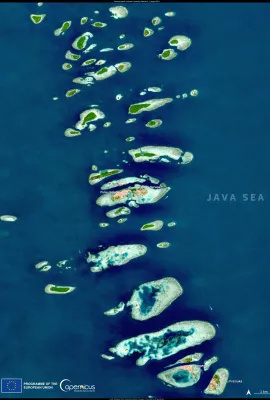
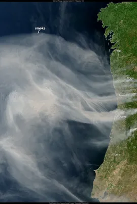
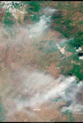
European Union flag
EU Space Policy

Explore EU Space

Results (1084)
Image of the Day
Wildfires aftermath in Pantanal visualised by Sentinel-2
Earth Observation | Copernicus
Located in the heart of South America, Pantanal is the world’s largest wetland covering some 81,081 sq miles (210,000 sq km). The majority is in Brazil, split between the states of Mato Grosso and Mato Grosso do Sul. These open marshes are home to an immense variety of life – if you like to see animals in their natural environment, the Pantanal...
Image of the Day
Earth Observation | Copernicus
The state of Malta covers two large and several smaller islands in the Mediterranean Sea. Malta has a vibrant history, owing to its strategic location as a naval base and harbour.  There are no permanent freshwater lakes or rivers on Malta due to its hot Mediterranean climate with dry summers. Together with the thin topsoil, vegetation on the...
Image of the Day
Earth Observation | Copernicus
The Victoria Falls presents a spectacular sight of awe-inspiring beauty on the Zambezi River, forming a natural border between Zambia and Zimbabwe. On July 5th, 2024, Copernicus Sentinel-2 captured a true colour, crystal-clear image of the city, river and the waterfalls. The water flow can be easily discerned.
Image of the Day
Earth Observation | Copernicus
Etna is the most active stratovolcano on the planet and one of the highest mountains in Italy, and the highest volcano in Europe, with a height of 3,357 metres. This Sentinel-2 image captured on July 7th, 2024, shows lava and ash spewing from the volcano crater. Copernicus Sentinel-2 satellites are important in monitoring volcanic activity...
Image of the Day
Earth Observation | Copernicus
The Arctic is disproportionately affected by climate change, and this is most evident during Northern Hemisphere summer. In some parts of Alaska, permafrost thawing seems to foster chemical weathering of minerals, microbial reduction of soil iron, and groundwater transport of metals to streams. This results in iron and trace metal-rich sediment...
Image of the Day
Earth Observation | Copernicus
Famed for its sugar-cubed houses and incredible number of pristine beaches, Serifos is one of the hidden gems of the Cyclades islands in Greece.  A wildfire on the 29th of June 2024 burned down and damaged houses, storage buildings, cottages, and small chapels and had 8 settlements in the south of the island evacuated. This image taken on July...
Image of the Day
Earth Observation | Copernicus
The Faroe Islands are dominated by glacial landforms, and due to the strong winds, the islands are practically treeless. Múlafossur is a spectacular waterfall on the island of Vágar in the Faroe Islands, dropping from a 30-meter cliff. The waterfall can be seen as a little white speck where the river in the first south-facing valley from the...
Image of the Day
Earth Observation | Copernicus
Wallis is an island and coral atoll in the South Pacific with a population of about 11,000 people under the jurisdiction of France.  Most of the residents sustain their livelihoods mainly through agriculture and fishing. Still, the unique location of the island also enables it to play a crucial role in the EU Space Programme. Wallis hosts a...
Image of the Day
Earth Observation | Copernicus
With the Hungarian EU Presidency beginning today, we have selected a scene from Hungary's most characteristic landscape, the Great Hungarian Plain.  This area is a low-lying sedimentary basin with topography dominated by fluvial landforms of low relief - a vast, flat area. This scene is a collection of landscapes typical for the region: on the...
Image of the Day
Copernicus Sentinel-2 captures Nyiragongo volcanic activity
Earth Observation | Copernicus
Nyiragongo, one of the world's most beautiful and active volcanoes, is a large stratovolcano near Lake Kivu at the eastern border of DR Congo with Rwanda in the Virunga National Park. On June 25, 2024, Copernicus Sentinel-2 captured a small volcanic activity.  This is a Sentinel-2 image with a Wildfire visualization custom script. This...
Image of the Day
Sentinel-1 eyes Ahuachapán in, El Salvador
Earth Observation | Copernicus
In June 2024, the Ahuachapán Department in western El Salvador has been affected by heavy rainfall that has caused a series of landslides and floods. Sentinel-1 images such as this one from 23 June 2024 can be collected through cloud cover and are therefore not sensitive to weather. On this false colour composite, water surfaces are dark blue...
Image of the Day
Lakes in Badain Jaran Desert
Earth Observation | Copernicus
Badain Jaran Desert is located in northern China, close to the Mongolian border. It is a sandy desert with occasional snow and extremely high dunes, but its most important peculiarity is the presence of a network of more than 100 lakes of varying size. These are fed by groundwater and occasional precipitation and are not connected by rivers on...
Image of the Day
Faro and Ria Formosa Lagoon
Earth Observation | Copernicus
Ria Formosa Lagoon is located on the Atlantic coast in southern Portugal. It is a system of tidal inlets and islands separated from the sea by barrier islands with long sandy beaches. The lagoon is protected under the Ramsar Convention and listed as an Important Bird Area as an essential resting place for migratory birds. Located inside the...
Image of the Day
Early heatwave in the Aegean Sea region
Earth Observation | Copernicus
The first heatwave of the summer season came unusually early for the Aegean Sea region during the weekend 15-16 June. At night, temperatures were typically above +30°C, and reached well above +40 °C during the day. The highest temperatures were recorded in Rhodes, Crete and Milos. These heatwave events are often caused by a so-called heat dome,...
Image of the Day
Grand Canyon from (very high) above
Earth Observation | Copernicus
Grand Canyon looks amazing from all perspectives. The geological kaleidoscope forming the colourful walls of the canyon is also visible on this satellite image, with the slope shadows also highlighting the forms of the buttes and mesas between the side valleys. At the very center of the image, the Colorado river is crossed by two narrow bridges...
Image of the Day
Niagara Falls between Canada and the USA
Earth Observation | Copernicus
Niagara Falls are a system of waterfalls on the Niagara River between Lake Erie and Lake Ontario. From west to east, the individual waterfalls are named Horseshoe Falls, Bridal Veil Falls and American Falls. The river flows from southeast to northwest on this image scene. The water flow over Horseshoe falls reaches maximum volume on late spring...
Image of the Day
Is that Mars or?
Earth Observation | Copernicus
This true colour Sentinel-2 image of Uluru / Ayers Rock was collected on 11 June 2024, during the local cold season. The relatively low-lying sun creates shadows in the gorges around the perimeter of the rock. The buildings of the aboriginal community of Mutitjulu are visible as white rectangles just east of Uluru. Apparently, vegetation is...
Image of the Day
Horns Rev wind park
Earth Observation | Copernicus
Offshore wind parks create renewable energy while having a lower visual footprint on the landscape. Horns Rev wind park in the North Sea off the Danish coast has a combined capacity of more than 700 MW and has been built in three phases. On this image, you can see the turbines of the last phase, Horns Rev 3, which have a hub height of over 100...
Image of the Day
Desertification in Chile
Earth Observation | Copernicus
Illapel, a town of about 30 000 inhabitants in the Coquimbo regio central Chile, is facing problems of water supply. Located in an area heavily affected by desertification, the town receives its drinking water from the El Bato reservoir. In 2022, this reservoir was filled to less than 10% of its capacity, leaving the city with the challenge of...
Image of the Day
Wildfire scar in southern France
Earth Observation | Copernicus
Summertime is on at the Cote d'Azur, but warming temperatures and clear skies can also have dangerous consequences. Due to the wet spring and dry summer, the dry biomass of undergrowth is unusually high, increasing the risk of wildfires. South of Vidauban near St. Tropez, an intensively burning wildfire was reported, which has destroyed over...

Showing 601-620 of 1084 results