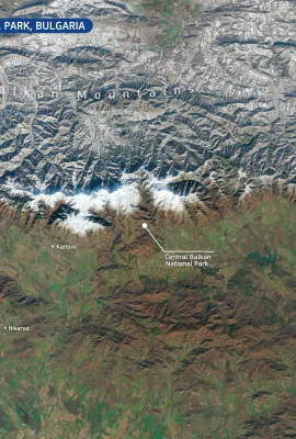
European Union flag
EU Space Policy

Explore EU Space

Results (1987)
Image of the Day
Copernicus in Emergencies
Earth Observation | Copernicus
In the face of natural or man-made disasters, the Copernicus Emergency Management Service (CEMS) provides On-Demand Mapping services  leveraging satellite imagery and other geospatial data. This information is key to supporting  response and recovery efforts around the globe, particularly regarding floods, earthquakes, landslides, hurricanes,...
Image of the Day
Dundalk Bay, Ireland
Earth Observation | Copernicus
Located on Ireland’s east coast, Dundalk Bay is a Natura 2000 site, recognised for its importance to an impressive range of marine and coastal species. It is protected under the European Birds Directive due to its role as a habitat for wintering waterbirds and migratory species. The bay's mudflats, sandflats, and estuarine ecosystems support...
Image of the Day
Hurricane Kirk
Earth Observation | Copernicus
This Copernicus Sentinel-3 image from 3 October 2024 shows Hurricane Kirk when it was about 2,000 km southwest of the Azores Archipelago. On the same day on which the image was acquired, Kirk swelled to a Category 4 storm in the central Atlantic Ocean as it made its way northeast, skirting the Caribbean islands and the eastern coast of the...
Image of the Day
The Jungfrau-Aletsch region of the Swiss Alps
Earth Observation | Copernicus
A recent analysis of the UNESCO World Heritage Sites threatened by climate change suggests that 17 of the 50 most at-risk sites are located on European territory. While flooding and drought were the leading potential hazards to the landmarks, coastal erosion, landslides, extreme temperatures, and storms could also pose threats to these...
Image of the Day
Ephemeral lakes in the Sahara Desert in Morocco
Earth Observation | Copernicus
This image, acquired by one of the Copernicus Sentinel-2 satellites on 1 October 2024, shows a series of ephemeral lagoons formed after torrential rains in Erg Chebbi, a sea of star dunes in the Sahara Desert in Morocco. These lagoons were formed by heavy rains in recent weeks. After seven years of drought, rainfall caused rivers from the Atlas...
Image of the Day
Agriculture in Austria and Slovakia
Earth Observation | Copernicus
This image, acquired by one of the Copernicus Sentinel-2 satellites on 18 June 2024, shows colourful fields of crops along the blue-coloured Danube River flowing through Austria and Slovakia. The cities of Vienna and Bratislava are visible in the left and right of the image, respectively. Copernicus plays a key role in enabling smarter,...
Image of the Day
The Hollandse Kust wind farm, the Netherlands
Earth Observation | Copernicus
This year, over half of the Netherlands' electricity has been produced from renewable sources like wind and solar power. In total, 32.3 billion kilowatt-hours were generated from renewables, accounting for 53% of the country's electricity production. Wind energy saw a significant increase, rising by a third to 17.4 billion kilowatt-hours, with...
News
OBSERVER: The latest Ocean State Report highlights record heat, shrinking sea ice, and innovations for a changing ocean
Earth Observation | Copernicus
The most recent edition of the EU Copernicus Ocean State Report (OSR 8) reveals a changing ocean, with record-breaking temperatures, dwindling polar sea ice, and marine heatwaves, including those in the Mediterranean Sea, which penetrated to depths of up to 1500 metres below the surface of the ocean. Other regions, such as the Baltic Sea and...
Image of the Day
Wildfire in the Peloponnese region of Greece
Earth Observation | Copernicus
On 29 September 2024, a wildfire broke out in the Peloponnese (Greece), prompting the evacuation of several villages. 350 firefighters were dispatched to battle the blaze, which spread rapidly due to strong winds. At least two deaths caused by the fire have been reported. Greece has been affected by more than 4,500 wildfires during the summer...
Image of the Day
The Guadiana Estuary in Portugal and Spain
Earth Observation | Copernicus
This Copernicus Sentinel-2 image, acquired on 10 September 2024, shows the Guadiana Estuary on the border of Portugal and Spain where the Guadiana River meets the Atlantic Ocean. This region is rich in biodiversity, with wetlands, salt marshes, a variety of fish and bird species, and at least 460 recorded plant species. Its waters play a...
Image of the Day
Drought depletes Lake Tefé, Brazil
Earth Observation | Copernicus
This Copernicus Sentinel-2 image acquired on 24 September 2024 shows a depleted Lake Tefé in northwestern Brazil. The city of Tefé, located along the Solimões River—one of the Amazon’s main tributaries—is also visible. This part of the Amazon Basin is currently facing record-low water levels due to an unprecedented drought. In 2024, the Amazon...
Image of the Day
Cambodia floods
Earth Observation | Copernicus
As of September 2024, nine provinces in Cambodia have been affected by severe flooding, which has damaged thousands of homes and led to the evacuation of hundreds of families. At least 9,000 hectares of rice paddies have been impacted by the flooding.  Authorities have issued warnings to residents living along the Mekong River, the waters of...
Image of the Day
Helene storm
Earth Observation | Copernicus
Hurricane Helene made landfall in northwestern Florida, USA, on 26 September 2024 as a powerful Category 4 storm and one of the largest storms in the Gulf of Mexico in the last century. With maximum sustained winds reaching 225 kilometers per hour, Helene triggered widespread hurricane, wind, and flash flood watches and warnings for 60 million...
Image of the Day
Moon
Earth Observation | Copernicus
The newly launched Copernicus Sentinel-2C satellite has captured an image you wouldn't expect – a spectacular view of the Moon. While the satellite is typically focused on Earth Observation, this image was acquired on 20 September as part of its calibration process. The Moon’s stable and well-known light intensity provides a perfect reference...

Showing 701-720 of 1987 results