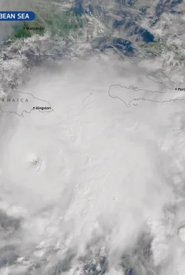
European Union flag
EU Space Policy

Explore EU Space

Results (1993)
Image of the Day
The absence of sea ice has led to the deaths of thousands of penguins in Antarctica
Earth Observation | Copernicus
In 2022, sea ice extent in Antarctica was the lowest ever recorded in the satellite era. A recent study, published in the prestigious Communications Earth & Environment scientific journal, revealed that during that year, four emperor penguin colonies 'skipped a generation' due to the premature melting of sea ice in the Bellingshausen Sea,...
News
Discover R&D for EO Security
Earth Observation | Copernicus
In 2021, the DG DEFIS and DG JRC, in coordination with the Copernicus Committee, User Forum and the entities implementing the Copernicus Security Services, joined efforts to enhance the streamlining of research and innovation based on user demand and operational requirements.
Image of the Day
Storm Daniel hit Greece, Bulgaria and Türkiye
Earth Observation | Copernicus
Storm Daniel, visible in this image acquired today, 6 September, at 08:48 UTC, is causing devastating floods in Greece, Türkiye, and Bulgaria.  There are at least seven casualties, including two tourists in northwestern Türkiye. In Istanbul, the heavy rainfall resulted in flooded streets and homes, claiming two lives. Greece experienced record...
Image of the Day
A new Saharan dust storm over western Europe
Earth Observation | Copernicus
This image acquired by one of the two Copernicus Sentinel-3 satellites on 4 September 2023 shows a massive Saharan dust plume stretching from the Mediterranean Sea to the Bay of Biscay in the Atlantic Ocean.  This dust plume, which at the time of the image acquisition extended over about 2,000 kilometres, is travelling in the direction of...
Image of the Day
Storm DANA hits Spain
Earth Observation | Copernicus
During the first weekend of September 2023, a slow-moving storm system, officially known as an upper-level isolated depression (DANA), has affected Spain, causing heavy rains and floods. The storm, as seen in this image acquired by a Copernicus Sentinel-3 satellite on 3 September, caused two casualties in Huesca. The Spanish Meteorological...
Image of the Day
Sicily’s Pantelleria island
Earth Observation | Copernicus
On 18 August, one of the Copernicus Sentinel-2 satellites acquired this image of Pantelleria.  The island, nestled in the Aegadian Archipelago (Italy), is a stopover for migratory birds. It been granted the prestigious UNESCO World Heritage status and is part of the Natura2000 network, recognised as a Special Protected Area and a Special Area...
Image of the Day
The smoke from Canadian fires has reached the Mediterranean Basin
Earth Observation | Copernicus
Relentless wildfires in Canada continue to produce vast amounts of smoke, leading to poor air quality conditions across the northern hemisphere. On 31 August, the smoke cloud reached Italy, Albania, and Greece after travelling over 10,000 kilometres, as visible in this Copernicus Sentinel-3 image acquired on the same day.  According to the...
Image of the Day
Hurricane Idalia hits Florida and Advances Across Georgia and South Carolina
Earth Observation | Copernicus
On 30 August, Hurricane Idalia reached category 3 before making landfall southeast of Tallahassee in a marshy and thinly populated part of Florida. It weakened and advanced through the Georgia and South Carolina as a tropical storm, causing extensive flooding and “dangerous coastal inundation”. Throughout Florida, neighbourhoods were flooded,...
Image of the Day
Western Canada engulfed in smoke
Earth Observation | Copernicus
Wildfires continue to plague Canada in, making this the worst wildfire season on record and exacerbating ongoing air quality issues due to dense smoke. The country has been ravaged by fires for the past three months, with numerous new blazes rapidly spreading across Alberta, British Columbia, and the Northwest Territories in recent days. The...
News
The success of Polish students
Earth Observation | Copernicus
Innovative ideas of Polish students in the use of satellite data of the Copernicus Programme
Image of the Day
Saharan dust plume reaches Greek coasts
Earth Observation | Copernicus
This image shows a plume of Saharan dust reaching Greece and was acquired by one of the Copernicus Sentinel-3 satellites on 29 August 2023. The large plume stretches hundreds of kilometres from the coast of Libya to the shores near the town of Pyrgos in Greece. These dust plumes have an impact on air quality. The Copernicus Atmospheric...
Image of the Day
Greece's biggest fire crisis continues
Earth Observation | Copernicus
Firefighters continue efforts to mitigate the fire that started near the town of Alexandroupoli and has already spread to the Evros region reaching the vicinity of the towns of Kotronia and Dadia where efforts are intensifying. The Dadia forest is severely affected and remains at risk if the wind picks up. On Monday 28 August, 474 firefighters,...
Image of the Day
Arafo-Candelaria
Earth Observation | Copernicus
In the early morning of 16 August 2023, a new fire started on the island of Tenerife, affecting several of the island's natural parks. Among them the Corona Forestal Natural Park, and the El Teide National Park. The #IFArafoCandelaria has forced hundreds of evacuations and affected a total of 12 municipalities on the island. Although the air...
Image of the Day
Wildfires in in the East Macedonia and Thrace region
Earth Observation | Copernicus
On Sunday 27 August, the fire in the Alexandroupolis area was still raging and the wind were fanning the flames, hampering firefighting efforts. On Sunday 27 August, 295 firefighters, seven aircraft and five helicopters were still trying to tame the fire. Meanwhile, the Copernicus Emergency Management Service continued to monitor the area...
Image of the Day
The wildfire in the Northeast Greece, one of the largest ever recorded in Europe
Earth Observation | Copernicus
The wildfire affecting the Greek port city of Alexandroupoli has become one of the largest fires ever recorded in Europe and has so far claimed the lives of 21 people while 15,000 people have been evacuated. This image captured by one of the Copernicus Sentinel-2 satellites on 25 August shows the thermal anomalies of the fire fronts near the...
Image of the Day
The biggest wildfire in Tenerife in the last 40 years
Earth Observation | Copernicus
The #IFArafoCandelaria is the most serious fire in Spain this year and the worst in the last 40 years in the Canary Islands. Ten days after it started, the evolution of the fire is starting to be favourable and less than 300 people remain under evacuation orders. The fire has affected the Corona Forestal Natural Park and the Teide National...

Showing 1221-1240 of 1993 results