OBSERVER: CORINE Land Cover, a key input to many Copernicus Services
For more than 35 years, CORINE Land Cover (CLC) has tracked how Europe's landscapes are changing. First developed to provide consistent geographic information on the state of the environment, CLC has evolved alongside European environmental policy, and its reach extends well beyond the service which produces it. It underpins a wide range of Copernicus Land Monitoring Service (CLMS) products, supports wildfire monitoring and disaster response products from the Copernicus Emergency Management Service (CEMS), and contributes to emissions mapping and air quality modelling products of the Copernicus Atmosphere Monitoring Service (CAMS). As demand for harmonised land cover data continues to grow, so too does CLC’s role across the Copernicus Services. With the sixth iteration set for release in Q3 2026, this Observer traces the history of CLC, examines its cross-service applications, and looks ahead to what the forthcoming update means for land cover monitoring across Europe.
Brief history of CLC
2025 marked the 35th anniversary of one of Europe’s longest-running harmonised land cover and land use inventories: CORINE Land Cover (CLC). While CLC is widely recognised as CLMS's flagship offering, it is also used across the Copernicus Services, feeding into products and analyses well beyond the Copernicus Land Monitoring Service which produces it.
The CORINE name stands for Coordination of Information on the Environment, and comes from a programme launched by the European Commission in 1985. The goal of the CORINE programme was to compile consistent geographic information on the state of the environment across Europe. Land cover and land use mapping were identified as core components, given their importance for environmental policy. The first official CLC map was released in 1994 (for the 1990 reference year) after years of extensive international coordination. The map covered most of the EU Member States at the time and established the foundational 44-class nomenclature, organised in a three-level hierarchical system.
Ten years later, the CLC 2000 status layer expanded geographic coverage significantly, incorporating new EU Member States and several candidate countries. For the first time, this update was produced by mapping land cover changes since 1990, integrating the resulting change layer into the previous status layer and correcting any misclassifications.
Following the success of CLC 2000, the European Commission sought a more institutional and sustainable framework for land monitoring. The project-based approach of the early CORINE years was increasingly seen as insufficient for Europe's growing environmental data needs. As a result, the production of CLC 2006 was embedded within the Global Monitoring for Environment and Security (GMES, the precursor of Copernicus) framework, marking an important shift towards an institutionalised land monitoring service coordinated by the European Environment Agency (EEA).
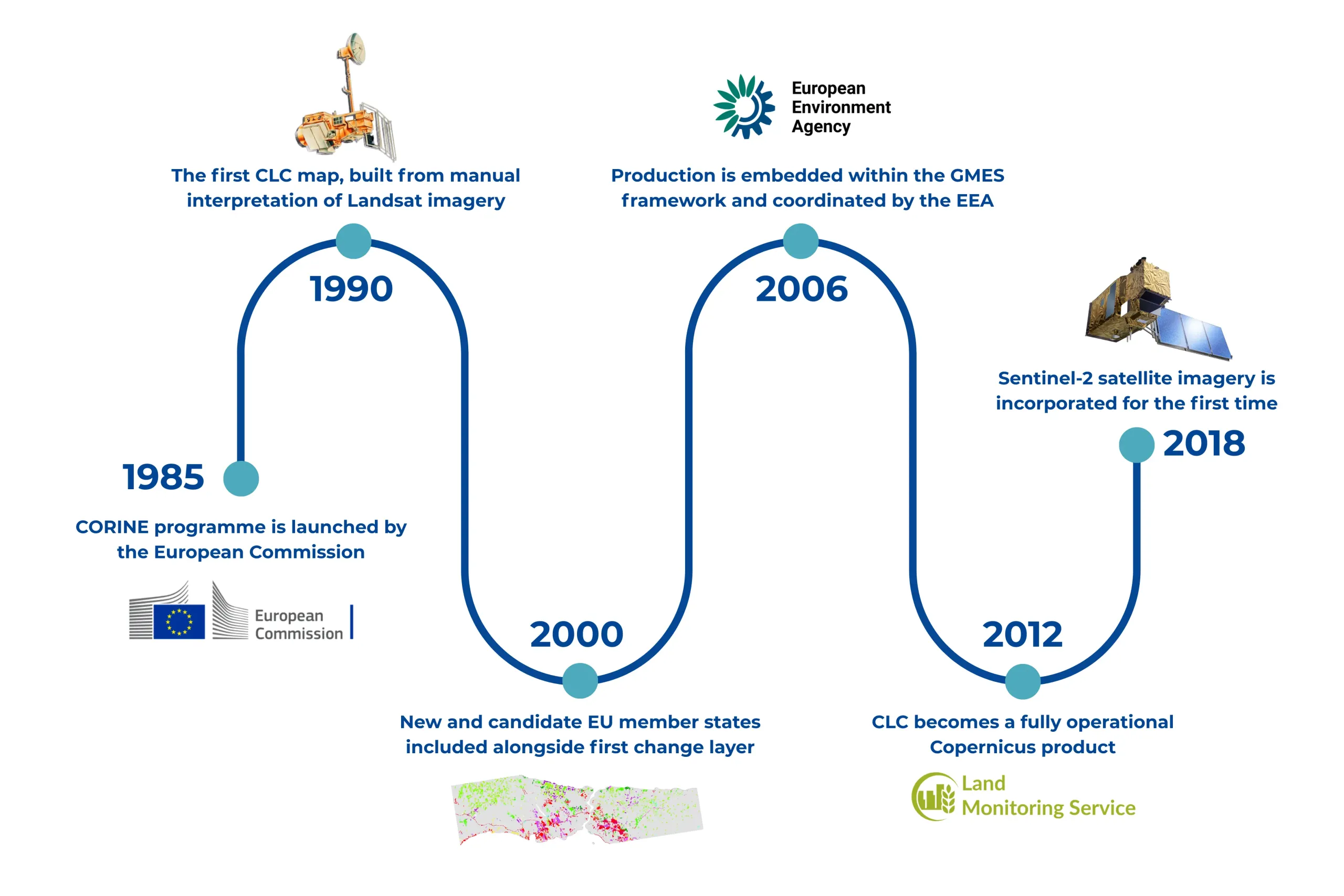
By the time the 2012 status layer was produced, CLC was already a fully operational part of Copernicus. Coverage became standardised across 39 European countries while quality control procedures were improved. The most recent full inventory, CLC 2018, was produced using Sentinel-2 and other high-resolution satellite data from Copernicus.
CLC 2024, the sixth iteration of CLC, is expected to be released to the public in Q3 2026. As in previous versions, it will include a status layer and a change layer, covering 39 European countries with land cover and land use information over 6 million square kilometres.
CLC for land monitoring
The applications of CLC are broad. Environmental planners and policymakers use it to monitor urban land take and soil sealing, track changes in agricultural land use, and assess habitat fragmentation and biodiversity loss. It supports planning of renewable energy installations and disease risk mapping, and plays an important role in national-level sustainability reporting. Across the Copernicus Services, it functions as a shared resource, informing operational outputs of the Land Monitoring Service, the Emergency Management Service, and the Atmosphere Monitoring Service.
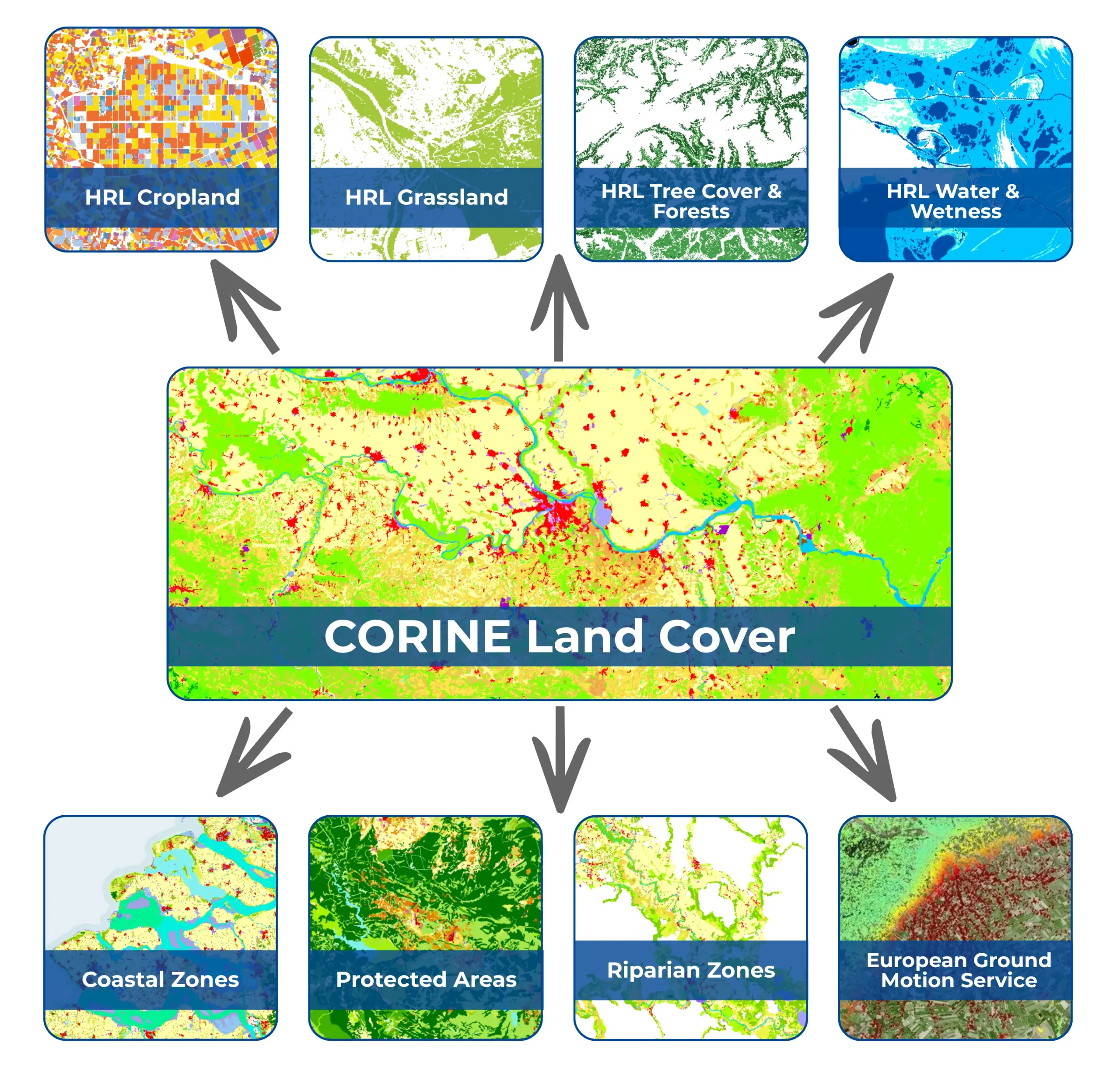
CLMS not only produces CLC, but also uses it across several parts of its product portfolio. CLC plays an important supporting role in the production of the High Resolution Layer Vegetated Land Cover Characteristics (HRL VLCC) product suite, which includes Tree Cover and Forests, Croplands, Grasslands, and Water and Wetness. The Base Vegetation Layer, which provides a harmonised annual map of vegetation types used to ensure consistency across the VLCC product suite, uses CLC as an auxiliary input, helping to filter training data and support the classification of specific land cover types. CLC also feeds into the Forest Additional Support Layer, in which it is cross-referenced with other map layers to identify tree cover associated with agricultural practices or urban contexts, which is an important step in the derivation of the Forest Type product.
CLC plays an important role across CLMS’ Priority Area products. Coastal Zones is a detailed 71-class land cover dataset covering roughly 730,000 km² of European coastal territory, and CLC is one of several inputs used alongside very high-resolution satellite imagery and Sentinel-2 time series to support classification and ensure consistency across datasets. CLC plays a comparable role in the N2K product, which provides detailed land cover and land use information for selected Natura 2000 sites, and in which data from 2006 and 2018 are directly integrated into the production workflow. In the Riparian Zones product, CLC data help guide the classification of satellite imagery, and the approach used to detect land cover change is borrowed directly from CLC.
CLC also plays a supporting role in the production and quality assurance of the European Ground Motion Service (EGMS). It is used as a consistency check during EGMS production, helping processing teams verify that ground movement measurements are in line with what would be expected for a given terrain type. CLC is also used to filter out areas such as wetlands and agricultural fields where apparent ground movement may simply reflect natural changes in surface properties rather than genuine displacement.
Finally, CLC data provide harmonised information on urban and natural green spaces, supporting health-related applications, such as the Copernicus Health Hub, by mapping green spaces and environmental conditions which impact public health.
CLC for emergency management
The Copernicus Emergency Management Service (CEMS) also incorporates CLC into several of its workflows and products. CEMS provides information to support emergency response, recovery efforts, and disaster risk reduction by using satellite imagery and other geospatial data to produce mapping services in response to natural hazards and human-induced disasters worldwide.
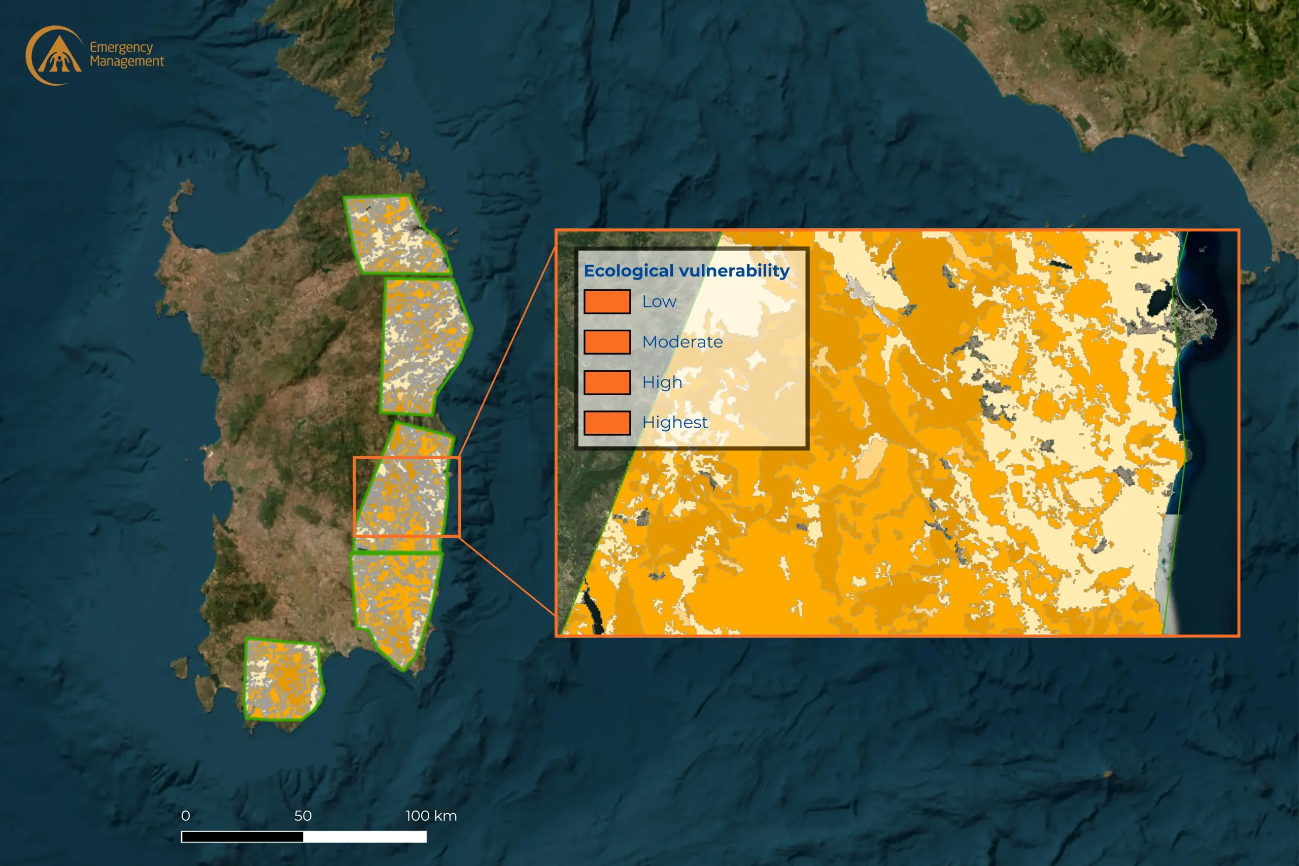
On-demand mapping is one of CEMS’ components, covering: preparedness (pre-event risk analysis), emergency mapping (immediate disaster response), and recovery (post-event impact assessment). CLC data are used in CEMS geospatial products to provide land cover information which supports further analyses, such as mapping burnt areas and assessing the impacts of wildfires or other disaster event types. For example, in a recent activation related to a large fire on the Italian island of Sardinia, CLC was used to create a buffer zone by grouping all land classified as “artificial areas” and generating a 100-metre buffer around them. These buffers delineate the area within which buildings, roads, and protected natural areas are considered exposed to wildfire. This allowed the number of buildings, total road length, and protected areas falling within the buffer zone to be quantified and compared across different wind scenarios.
The CEMS European Forest Fire Information System (EFFIS) also uses CLC data to determine the land cover and land use categories affected by fire danger or burn scars. This enables harmonised comparisons between countries and regions, supporting consistent assessment of fire damage across Europe. Through EFFIS, users can visualise land cover types impacted by wildfires or risk thereof and download relevant datasets for further analysis. These data are compiled in an annual report on wildfire impacts.
CLC for atmosphere monitoring
The Copernicus Atmosphere Monitoring Service (CAMS) provides forecasts and historical data on atmospheric conditions such as air quality, greenhouse gas emissions and concentrations, solar radiation, and natural sources of pollution. These data support users across environmental policy, development and operations of renewable energy production facilities, public health, and related fields. Central to this work are two elements: mapping the sources of pollutants and modelling how they move through the atmosphere. CAMS produces regional emission inventories, which track pollution sources across Europe, and operates the CAMS Ensemble Forecasts, a suite of atmospheric models used to forecast air quality and analyse pollutant concentrations, chemical transformation, and deposition.
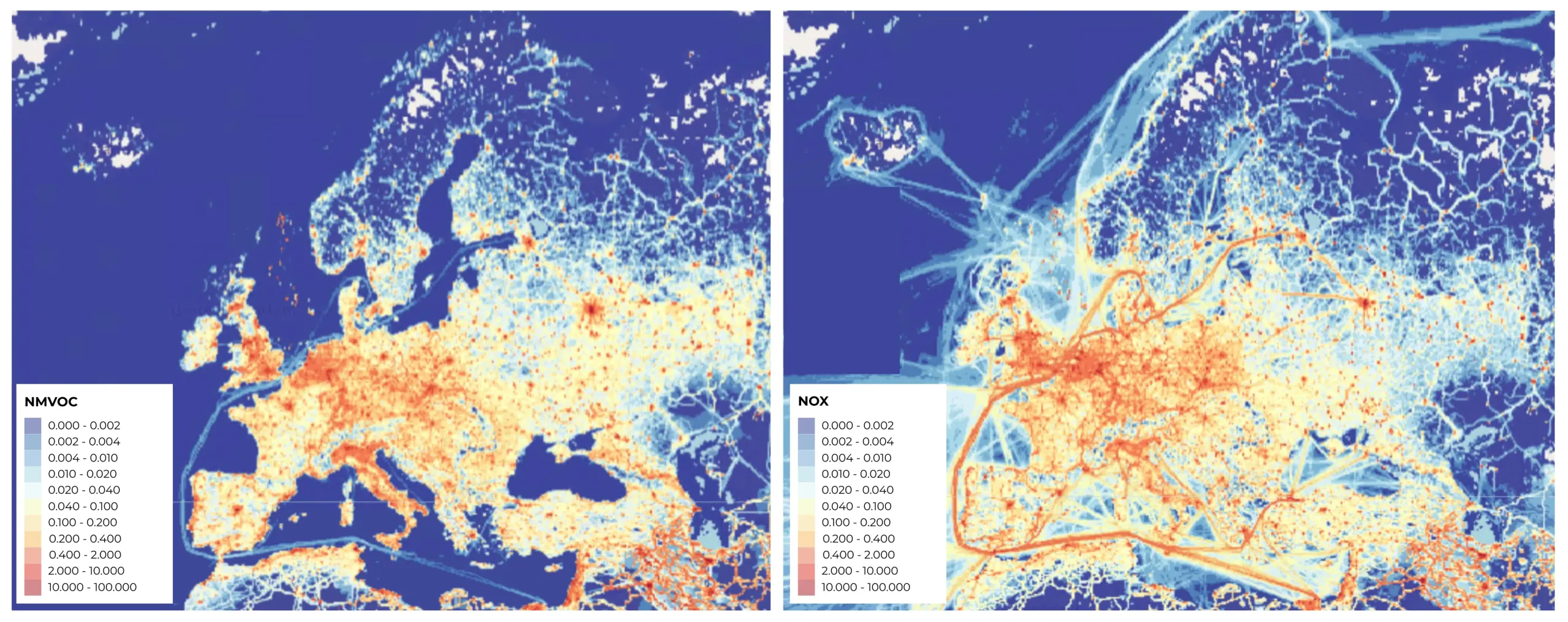
In the regional emissions inventories, CLC data are used to map how nationally reported emissions are distributed across the landscape. In practice, this means that rather than spreading emissions evenly across a country or region, the model uses CLC's land cover classifications to allocate them to the parts of the landscape where they are most likely to originate. For example, industrial and urban areas generate different emission profiles than forests or agricultural land.
CLC also feeds into the regional chemistry transport models which make up the CAMS Ensemble Forecasts. Here, land cover information plays a less direct but still important role by allowing the models to represent the interactions between the land surface and the atmosphere above it. This includes the assessment of how pollutants settle back onto the land, the release of natural compounds and aeroallergens from vegetation and soils, and the influence of land surface type on the production of naturally occurring airborne particles such as mineral dust. In each of these areas, knowing what kind of land cover is present helps the models produce more accurate and physically realistic outputs.
Looking ahead
With the forthcoming release of the 2024 edition of CORINE Land Cover, the use of CLC across the Copernicus Services will continue to grow. The new update will provide more recent baseline data, ensuring that the analyses and products which rely on CLC remain grounded in the most current picture of Europe's landscape. As climate change continues to intensify the frequency and severity of natural hazards, the demand for accurate, harmonised land cover data will only increase. CLC, with its long production history and its deep integration across the Copernicus services, is well positioned to meet that demand.
What began as a European effort to harmonise environmental information has become a shared reference point for land monitoring, emergency management, and atmospheric modelling. With CLC 2024, that reference point will be updated for a new generation of Copernicus products and applications.