OBSERVER: How the Copernicus Land Monitoring Service helps protect rangelands
The International Year of Rangelands and Pastoralists 2026 is bringing global attention to ecosystems which cover more than half of the Earth's land surface, support the livelihoods of nearly two billion people, and store roughly one-third of the planet's terrestrial carbon. Yet for decades, these vast grasslands, steppes, and savannahs have been treated as marginal landscapes, often undervalued and under-monitored. The Copernicus Land Monitoring Service (CLMS) provides consistent, large-scale data needed to track rangeland health and inform the decisions which affect the communities which depend on these ecosystems. In this Observer, we examine how CLMS supports the monitoring of one of the world's most important and often overlooked ecosystems.
Across the grasslands of the Sahel, the dry steppes of Central Asia, and the increasingly fragile pastoral landscapes of the Mediterranean, a quiet transformation is underway. Climate change, land degradation, drought, and competing land uses are placing unprecedented pressure on some of the world’s oldest and most resilient ecosystems: rangelands.
These landscapes, often dismissed as empty or marginal, support the livelihoods of nearly two billion people, including around 500 million pastoralists, and cover more than half of the Earth’s land surface. They provide around 70% of global livestock feed and nearly one-sixth of the world’s food supply. They are also home to roughly one-third of global biodiversity hotspots.
The International Year of Rangelands and Pastoralists 2026 seeks to change the global perception of these ecosystems. At the centre of this shift is a growing recognition that protecting rangelands is not only an environmental issue, but also a matter of food and water security, climate resilience, biodiversity conservation, and sustainable development. In this context, satellite data is becoming one of the key tools for improving understanding of changes on the ground and supporting better-informed decisions.
Landscapes built on movement
“Pastoral systems have evolved over millennia to manage climatic variability and scarce resources in highly dynamic environments,” explains Dr Barron Joseph Orr, Chief Scientist at the United Nations Convention to Combat Desertification (UNCCD). “Mobility-based grazing systems allow pastoralists to adapt to changing rainfall patterns and forage availability while maintaining ecosystem function across large landscapes.”
Today, this balance is increasingly under threat. Agricultural expansion, infrastructure development, mining, land fragmentation, and restrictive land policies are reducing pastoral mobility, increasing pressure on grazing areas, and contributing to the overexploitation of rangelands. At the same time, climate change is intensifying droughts, raising temperatures, and accelerating ecosystem stress across drylands.
According to recent UNCCD assessments, up to half of global rangelands are already degraded or at risk of degradation. The consequences of this extend well beyond the livelihoods of pastoral communities. Rangelands make up about one-third of the planet’s terrestrial carbon reservoir capacity and play a crucial role in regulating water cycles, maintaining biodiversity, and buffering climate shocks.
“Rangelands are ‘optimal ground’ for maximising synergies between Land Degradation Neutrality, biodiversity conservation, climate mitigation and adaptation, and rural development,”
— Dr. Barron Joseph Orr
Chief Scientist, United Nations Convention to Combat Desertification (UNCCD)
Seeing drylands from space
Monitoring ecosystems which stretch across continents has always been a challenge. Ground observations alone are often not enough, especially in remote pastoral regions in which environmental conditions can change rapidly.
In this context, Earth Observation (EO), and particularly the Copernicus Land Monitoring Service (CLMS), plays an increasingly important role. Satellite monitoring allows scientists and decision-makers to observe vegetation productivity, land cover change, ecosystem stress, and drought conditions consistently over time and across large areas.
“Earth Observation is improving how we monitor and assess rangelands by allowing dynamic ecosystem processes to be observed consistently across large spatial and temporal scales,” says Dr Orr. Satellite data also helps to make visible the multiple functions of rangelands which are often underestimated in policymaking: carbon storage, biodiversity protection, water regulation, and food production.
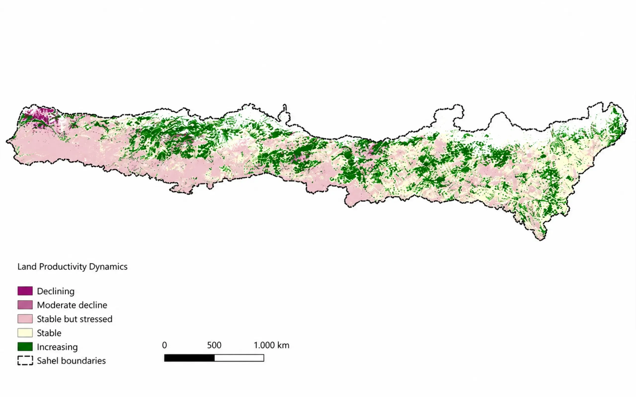
CLMS datasets on land cover, vegetation productivity, and land condition monitoring already play a role in supporting the objectives of the UNCCD, particularly around Land Degradation Neutrality (LDN) and drought resilience. The JRC Land Productivity Dynamics dataset, for example, is already used as one of the UNCCD’s global default datasets for monitoring land degradation.
The importance of long-term monitoring
Drylands are ecosystems of extremes. Rainfall patterns shift dramatically from one year to the next, and a single poor season does not necessarily signal lasting decline. Equally, a good rainy season can temporarily mask underlying ecological deterioration.
This makes long-term satellite records even more relevant. “Variability is a normal characteristic of these ecosystems, not necessarily a sign of degradation,” Dr Orr explains. “Without long-term observations, there is a risk of misinterpreting temporary responses to drought or climate variability as permanent land degradation.”
Multi-decadal EO records allow researchers to distinguish short-term climatic fluctuations from more persistent ecological decline. This is especially important as climate change shifts environmental baselines across many dryland regions.
The value of this approach is already evident in regions such as the Sahel, where livelihoods are closely tied to rainfall variability, and in Mongolia, where increasingly frequent “dzud” events, cold-season disasters in which snow, ice, extreme cold, or lack of vegetation prevent livestock from grazing, are threatening pastoral systems.
Mediterranean drylands are also emerging as areas of growing concern, with rising temperatures, prolonged droughts, and wildfire risks placing mounting pressure on ecosystems and rural communities alike.
Beyond data: combining satellites and local knowledge
Satellite data provide an invaluable way to observe rangeland ecosystems across large, remote, and changing landscapes, but these data still show only part of the picture. Pastoralist communities possess generations of ecological knowledge which satellites cannot fully capture: grazing patterns, mobility routes, seasonal resource use, and subtle ecosystem signals observable only on the ground.
“Earth Observation provides consistent, large-scale spatial insights, but it cannot fully capture the socio-ecological dynamics of pastoral systems,” Dr Orr says.
For this reason, combining satellite monitoring with Indigenous and local knowledge is increasingly seen as essential for sustainable land governance.
Integrating both perspectives improves not only interpretation and validation, but also trust, legitimacy, and the practical relevance of monitoring systems for local communities.

Open data as a global equaliser
Copernicus data are free and openly accessible. For many countries in the Global South where monitoring capacities and financial resources are limited, this access can be transformative.
“Open access to satellite data is a game changer,” Dr Orr emphasises. “By removing cost barriers, initiatives such as Copernicus enable countries to access high-quality spatial data which would otherwise be out of reach.”

This is particularly important for countries working towards Land Degradation Neutrality targets under the UNCCD framework, in which reliable and consistent monitoring is essential.
Access alone, however, is not enough. Capacity building, user-friendly tools, and integration into national decision-support systems remain key challenges. This is one reason why the UNCCD is working with technical partners, including the Joint Research Centre, to support the 2026 reporting process. The JRC is among the partner regional institutions providing technical support for the 2026 UNCCD reporting cycle, including through regional capacity-building activities for countries from Central Asia, the Northern Mediterranean, and Central and Eastern Europe.
From “marginal lands” to global priorities
The International Year of Rangelands and Pastoralists is about changing how rangelands are understood. For decades, rangelands were often viewed as underutilised spaces awaiting “development.” Today, research increasingly shows the opposite: these ecosystems are crucial global assets for climate adaptation, biodiversity conservation, and sustainable food systems.
“The long-term legacy should be greater recognition, sustained investment, and stronger policy support for sustainable rangeland stewardship and the communities which depend on these ecosystems,” says Dr Orr. That ambition is reflected in the theme chosen for Desertification and Drought Day 2026: “Rangelands: Recognize. Respect. Restore.”
Recognition means acknowledging the ecological and economic value of these landscapes. Respect means valuing the knowledge and rights of pastoralist and Indigenous communities. Restore means investing in long-term resilience.
As the world prepares for UNCCD COP17 in Mongolia, likely the largest global gathering ever focused on rangelands and pastoralism, satellite monitoring, open data, and services such as CLMS are becoming central to a new vision of dryland governance.