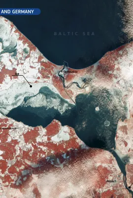
European Union flag
EU Space Policy

Explore EU Space

Results (1987)
Image of the Day
A rare, cloud-free image of Trondheim, Norway
Earth Observation | Copernicus
Trondheim has a lot to offer, from vibrant urban nightlife to breathtaking natural surroundings, a rich history, and some of Norway's most beautiful landmarks. This scene shows a rare cloud-free Sentinel-2 image of Trondheim and Trondheim Fjord in Norway. It is a true colour visualization with some corrections applied to gain and the green...
Image of the Day
Algae bloom formation in the Baltic Sea/Curonian Lagoon
Earth Observation | Copernicus
The Curonian Spit is a long and thin sand-dune spit that separates the Curonian Lagoon from the Baltic Sea. Formed by the accumulation of glacial debris, and sand carried by the wind, it is a UNESCO World Heritage Site, whose northern part lies in Lithuania. The Spit is an important ecological area and home to several migratory bird species,...
Image of the Day
Exploring the island of Halmahera
Earth Observation | Copernicus
The Dukono volcano is a remote volcano on the island of Halmahera, Maluku, Indonesia. It is one of the world’s most active volcanoes. Dukono with a height of 1185 meters above sea level is located in the northern part of Halmahera Island.  In this Copernicus Sentinel-2 Image acquired on 29 May 2024, we see ash from the volcano crater,...
Image of the Day
Wildfires aftermath in Pantanal visualised by Sentinel-2
Earth Observation | Copernicus
Located in the heart of South America, Pantanal is the world’s largest wetland covering some 81,081 sq miles (210,000 sq km). The majority is in Brazil, split between the states of Mato Grosso and Mato Grosso do Sul. These open marshes are home to an immense variety of life – if you like to see animals in their natural environment, the Pantanal...
News
OBSERVER: Seven times the Copernicus Sentinel-2 mission gave us stunning images of our planet
Earth Observation | Copernicus
Copernicus provides accurate, timely, and easily accessible information to users around the world, improving the operations of emergency management services, deepening our understanding of climate change, helping us better manage natural resources and conserve biodiversity, and much more. Using a series of dedicated satellites, known as the...
Image of the Day
Earth Observation | Copernicus
The state of Malta covers two large and several smaller islands in the Mediterranean Sea. Malta has a vibrant history, owing to its strategic location as a naval base and harbour.  There are no permanent freshwater lakes or rivers on Malta due to its hot Mediterranean climate with dry summers. Together with the thin topsoil, vegetation on the...
Image of the Day
Earth Observation | Copernicus
The Victoria Falls presents a spectacular sight of awe-inspiring beauty on the Zambezi River, forming a natural border between Zambia and Zimbabwe. On July 5th, 2024, Copernicus Sentinel-2 captured a true colour, crystal-clear image of the city, river and the waterfalls. The water flow can be easily discerned.
Image of the Day
Earth Observation | Copernicus
Etna is the most active stratovolcano on the planet and one of the highest mountains in Italy, and the highest volcano in Europe, with a height of 3,357 metres. This Sentinel-2 image captured on July 7th, 2024, shows lava and ash spewing from the volcano crater. Copernicus Sentinel-2 satellites are important in monitoring volcanic activity...
Image of the Day
Earth Observation | Copernicus
The Arctic is disproportionately affected by climate change, and this is most evident during Northern Hemisphere summer. In some parts of Alaska, permafrost thawing seems to foster chemical weathering of minerals, microbial reduction of soil iron, and groundwater transport of metals to streams. This results in iron and trace metal-rich sediment...
Image of the Day
Earth Observation | Copernicus
Famed for its sugar-cubed houses and incredible number of pristine beaches, Serifos is one of the hidden gems of the Cyclades islands in Greece.  A wildfire on the 29th of June 2024 burned down and damaged houses, storage buildings, cottages, and small chapels and had 8 settlements in the south of the island evacuated. This image taken on July...
News
OBSERVER: Advancing Earth Observation with the Copernicus Sentinel Expansion Missions
Earth Observation | Copernicus
The Copernicus satellite missions currently in orbit provide invaluable data that feed a vibrant ecosystem of Earth Observation products and services across diverse application areas. Copernicus is served by a set of six dedicated satellite families, the Sentinels, which are specifically designed to meet the needs of the Copernicus services and...
Image of the Day
Earth Observation | Copernicus
The Faroe Islands are dominated by glacial landforms, and due to the strong winds, the islands are practically treeless. Múlafossur is a spectacular waterfall on the island of Vágar in the Faroe Islands, dropping from a 30-meter cliff. The waterfall can be seen as a little white speck where the river in the first south-facing valley from the...
Image of the Day
Earth Observation | Copernicus
Wallis is an island and coral atoll in the South Pacific with a population of about 11,000 people under the jurisdiction of France.  Most of the residents sustain their livelihoods mainly through agriculture and fishing. Still, the unique location of the island also enables it to play a crucial role in the EU Space Programme. Wallis hosts a...
Image of the Day
Earth Observation | Copernicus
With the Hungarian EU Presidency beginning today, we have selected a scene from Hungary's most characteristic landscape, the Great Hungarian Plain.  This area is a low-lying sedimentary basin with topography dominated by fluvial landforms of low relief - a vast, flat area. This scene is a collection of landscapes typical for the region: on the...
Image of the Day
Copernicus Sentinel-2 captures Nyiragongo volcanic activity
Earth Observation | Copernicus
Nyiragongo, one of the world's most beautiful and active volcanoes, is a large stratovolcano near Lake Kivu at the eastern border of DR Congo with Rwanda in the Virunga National Park. On June 25, 2024, Copernicus Sentinel-2 captured a small volcanic activity.  This is a Sentinel-2 image with a Wildfire visualization custom script. This...
News
OBSERVER: Celebrating nine years of Copernicus Sentinel-2A
Earth Observation | Copernicus
On 23 June 2015, the first Copernicus Sentinel-2 satellite was launched. It was the second Copernicus satellite sent to space, just a little over one year after the launch of Sentinel-1A. Copernicus’ first ‘colour-vision’ mission, Sentinel-2, aimed to improve our capabilities in monitoring land and vegetation cover as well as crop growth,...
Image of the Day
Sentinel-1 eyes Ahuachapán in, El Salvador
Earth Observation | Copernicus
In June 2024, the Ahuachapán Department in western El Salvador has been affected by heavy rainfall that has caused a series of landslides and floods. Sentinel-1 images such as this one from 23 June 2024 can be collected through cloud cover and are therefore not sensitive to weather. On this false colour composite, water surfaces are dark blue...
Image of the Day
Lakes in Badain Jaran Desert
Earth Observation | Copernicus
Badain Jaran Desert is located in northern China, close to the Mongolian border. It is a sandy desert with occasional snow and extremely high dunes, but its most important peculiarity is the presence of a network of more than 100 lakes of varying size. These are fed by groundwater and occasional precipitation and are not connected by rivers on...

Showing 801-820 of 1987 results