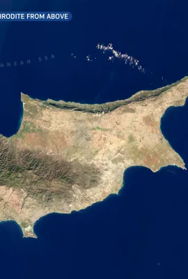
Ria Formosa Lagoon is located on the Atlantic coast in southern Portugal. It is a system of tidal inlets and islands separated from the sea by barrier islands with long sandy beaches. The lagoon is protected under the Ramsar Convention and listed as an Important Bird Area as an essential resting place for migratory birds. Located inside the...
Results (1987)
CNES and ENSG (Ecole Nationale des Sciences Géographiques) recently provided technical training in interferometry for Vietnamese young researchers.
The first heatwave of the summer season came unusually early for the Aegean Sea region during the weekend 15-16 June. At night, temperatures were typically above +30°C, and reached well above +40 °C during the day. The highest temperatures were recorded in Rhodes, Crete and Milos. These heatwave events are often caused by a so-called heat dome,...
ROSA | Bucharest | Romanian
Grand Canyon looks amazing from all perspectives. The geological kaleidoscope forming the colourful walls of the canyon is also visible on this satellite image, with the slope shadows also highlighting the forms of the buttes and mesas between the side valleys. At the very center of the image, the Colorado river is crossed by two narrow bridges...
Niagara Falls are a system of waterfalls on the Niagara River between Lake Erie and Lake Ontario. From west to east, the individual waterfalls are named Horseshoe Falls, Bridal Veil Falls and American Falls. The river flows from southeast to northwest on this image scene. The water flow over Horseshoe falls reaches maximum volume on late spring...
The Copernicus Land Monitoring Service (CLMS) had an exciting start to the month, celebrating its first General Assembly from June 3-5 in Antwerp, Belgium. This hybrid event brought together over 300 participants — including scientists, policymakers, and industry professionals — to shape the future of CLMS.
This true colour Sentinel-2 image of Uluru / Ayers Rock was collected on 11 June 2024, during the local cold season. The relatively low-lying sun creates shadows in the gorges around the perimeter of the rock. The buildings of the aboriginal community of Mutitjulu are visible as white rectangles just east of Uluru. Apparently, vegetation is...
Offshore wind parks create renewable energy while having a lower visual footprint on the landscape. Horns Rev wind park in the North Sea off the Danish coast has a combined capacity of more than 700 MW and has been built in three phases. On this image, you can see the turbines of the last phase, Horns Rev 3, which have a hub height of over 100...
Illapel, a town of about 30 000 inhabitants in the Coquimbo regio central Chile, is facing problems of water supply. Located in an area heavily affected by desertification, the town receives its drinking water from the El Bato reservoir. In 2022, this reservoir was filled to less than 10% of its capacity, leaving the city with the challenge of...
Summertime is on at the Cote d'Azur, but warming temperatures and clear skies can also have dangerous consequences. Due to the wet spring and dry summer, the dry biomass of undergrowth is unusually high, increasing the risk of wildfires. South of Vidauban near St. Tropez, an intensively burning wildfire was reported, which has destroyed over...
Presentations and Video links of the 3rd Webinar on the FPCUP WG Africa Training of Trainers Programme.
Cloud forests are highly diverse ecosystems where the conditions are humid, but instead of regular precipitation water is available as the condensation of fog or low-altitude clouds. Monteverde Cloud Forest Reserve is known for its extremely rich flora and fauna with many species that are unique to the region. The reserve is gradually gaining...
On 13 June 2024, DG DEFIS hosted the 6th meeting of the EU Industry and Start-ups Forum on Space Traffic Management (EISF).
Presentations and Video links of the 3rd Webinar on the FPCUP WG Africa Training of Trainers Programme.
The Øresund bridge is one of the longest bridges in the world, spanning the Øresund straight between Denmark and Sweden. The bridge connects to a tunnel which the road and railway enters on a small artificial island. The main span is supported by a system of cables on two large pylons - these are difficult to spot due to their small footprint,...
Prepared jointly by Directorate Generals for Defence Industry and Space, Research and Innovation, and the European Commission’s Joint Research Centre (JRC), the Strategic Research and Innovation Agenda (SRIA) for Earth Observation outlines the future trajectory for Copernicus, the EU’s Space Programme’s Earth Observation component. By...
Most of us live on land, and it is easy to forget that more than 70 percent of the Earth's surface is covered by the Ocean. But at Cape Horn, the southernmost tip of the Tierra del Fuego Archipelago in Chile, the importance and the power of the ocean is evident. It was exceedingly difficult to find an image of this place that is not completely...
Korission Lagoon is located on the southwestern corner of Corfu Island in Greece. The lagoon has fresh water and is close to the sea but separated by the sand dunes, so it is a biodiversity hotspot with very high species richness. This true colour Sentinel-2 image shows the lagoon and the surrounding natural and agricultural areas and the...
Challenge to enhance the Earth Observation community's ability to map and monitor the impact of human activities on the biosphere.
Showing 821-840 of 1987 results