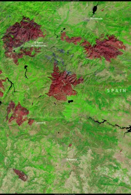
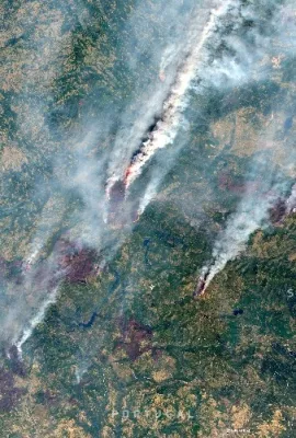
The EU is the second largest producer of potatoes globally with output rounding up to more than 53 million tonnes harvested each year. Additionally, the EU takes first place when it comes to the quantity of potatoes consumed per capita. In one year, every European consumes on average almost 90 kg of potatoes.
Results (1987)
This image, acquired on 28 February 2023 by one of the Copernicus Sentinel-3 satellites, shows Storm Juliette sweeping across the island of Mallorca. An alert has been issued for the island, warning of possible 8-metre waves and heavy snowfall, with temperatures dropping as low as -2°C. Experts have also warned that snowfall of up to 40cm could...
The aim of this Action is to prepare, deliver and assess a cycle of training events, each of them being named as Copernicus Open School, along with the creation of a Community of practice (CP) and some innovative MOOCs.
The objective of the service is to generate an on-line and publicly available information platform on forests based on the data provided by the Copernicus service to support private forest owners in implementing sustainable forest management activities.
On 19 February 2023, disastrous floods hit the state of São Paulo in Brazil, causing widespread damage and claiming the lives of 57 people. The heavy rains triggered landslides and flooding in coastal towns of the country’s richest state, causing extensive damage to housing and infrastructure. More than 4,000 people were forced to evacuate...
This image, acquired on 26 February 2023 by one of the Copernicus Sentinel-3 satellites, shows dust engulfing the skies over Southern Italy, Malta, and part of Greece. Over the past two weeks, multiple Saharan dust storm episodes have deteriorated air quality in Southern Europe. These dust storms are harmful to human health, causing many...
CBK PAN | Jagiellonian University in Kraków (Poland) | Polish
Copernicus is the world's largest provider of Earth Observation data, and its launch has been a defining moment, not only for the remote sensing community but for all scientists, entrepreneurs, and citizens in the EU and beyond.
Severe weather conditions recently hit Morocco, causing snow cover to reach up to 1.7 metres in some areas of the Ouarzazate province. The heavy snowfall significantly affected the local population, and 9,000 families will benefit from emergency humanitarian aid, consisting mainly of food and blankets. This extreme weather has also had a...
A Saharan dust storm is currently in motion and heading towards central and eastern Europe. On 21 February, it was captured by one of the Copernicus Sentinel-3 satellites south of the Iberian Peninsula. The Copernicus Atmosphere Monitoring Service has accurately forecasted the movement and density of dust transport and evaluated the levels of...
WG Africa | Lisbon | English
Coastal erosion is rapidly changing the French coastline, particularly in areas along the coast of the Atlantic Ocean. This image, acquired by one of the Copernicus Sentinel-2 satellites on 12 February, shows the area of Soulac-sur-Mer, located at the northernmost tip of the Gironde estuary. In this area, beaches are receding at a rate of 2.5...
Be part of the Copernicus data & services Community!
UN-SPIDER, DLR and University of Bonn | Bonn | English
February marks the peak of summer in Antarctica, providing the opportunity to observe unusual phenomena affecting the continent's ice. On 16 February, one of the Copernicus Sentinel-2 satellites captured a rare image of green-tinged sea ice due to a phytoplankton bloom in the Ross Sea. In 2017, the same phenomenon of green ice was observed in...
On 19 February at 05:00 UTC, one of the Copernicus Sentinel-3 satellites acquired this image of Freddy, a very intense tropical cyclone currently active in the Indian Ocean. The storm is expected to approach Mauritius Island and La Réunion on 20 February before hitting the coast of Madagascar on 21 February, bringing along strong winds, heavy...
Bushfires are affecting the Western Downs region of Queensland, Australia. These fires have burnt more than 7,400 hectares of vegetation, causing significant damage. On 16 February, one of the Copernicus Sentinel-2 satellites captured a pyrocumulus cloud produced by a fire ongoing near Pelham. This type of cloud develops as a result of the...
This image, acquired on 15 February 2023 by one of the Copernicus Sentinel-2 satellites, shows the reduced flow of the Po River north of Voghera, in northern Italy. The entire Po Valley is affected for the second year in a row by severe drought conditions. According to the ANBI Observatory, the Po River reached its all-time record low levels in...
The shift towards a digital era has increased the reliance on connectivity for businesses, governments and people. Secure connectivity is essential to enabling everyday operations as well as ensuring the viability of critical infrastructure systems, such as power grids and financial systems that are connected and controlled through digital networks
This image, acquired on 12 February 2023, shows part of the province of Málaga in southern Spain, which is renowned for its almond groves. In this area an early blossoming of almond trees is ongoing. Since it is still winter, the flowers are vulnerable to frost, which puts the summer harvest at risk. A poor almond harvest can have serious...
Showing 1461-1480 of 1987 results