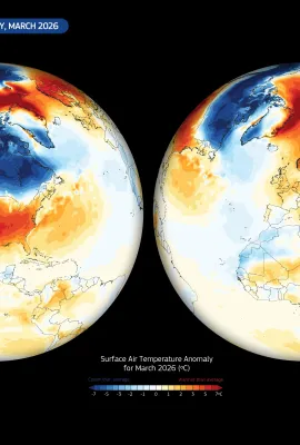
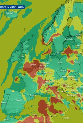
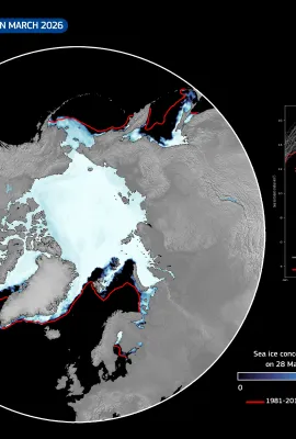
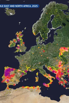
European Union flag
EU Space Policy

Explore EU Space

Beta version - We are continuously improving search functionality

Results (1008)
Image of the Day
The Jade Bight, Germany
Earth Observation | Copernicus
11 October marks World Migratory Bird Day, dedicated to raising awareness for the conservation and protection of migratory birds and their unique habitats around the world.  The Jade Bight in Germany, internationally recognised for its importance in bird staging and migration, is a designated Ramsar site and part of the Wadden Sea UNESCO World...
Image of the Day
Kati Thanda, Australia
Earth Observation | Copernicus
Kati Thanda (or Lake Eyre), Australia's largest salt lake, is located in the arid interior of South Australia. This unique and fragile inland basin is typically dry during the austral spring, which takes place between September and November.  October typically marks the return of high temperatures and intense evaporation, leaving behind only...
Image of the Day
The CLMS Global Land Cover product
Earth Observation | Copernicus
This data visualisation is based on the Global Land Cover product from the Copernicus Land Monitoring Service (CLMS), released in June 2025 as part of the new Land Cover and Forest Monitoring (LCFM) suite. Based on Copernicus Sentinel-2 data, the Global Land Cover product provides a detailed view of the Earth’s surface for the year 2020, with a...
Image of the Day
Hurricane Priscilla hits Mexico
Earth Observation | Copernicus
Priscilla formed in early October 2025, becoming the fourth major hurricane of this Pacific season. It rapidly strengthened from a tropical depression to reach hurricane status within 48 hours. It swept across a region of high ecological value along Mexico’s western coastline, home to mangrove forests, coastal wetlands, and rich marine...
Image of the Day
Satellite image of Aalborg, Denmark, showing the city divided by a river with surrounding green farmland and rural areas.
Earth Observation | Copernicus
Aalborg, Denmark’s fourth-largest city, blends urban life with ecological awareness. Surrounded by a mosaic of agricultural land, parks, and bodies of water, the area supports diverse ecosystems which benefit from sustainable urban planning and environmental monitoring. The city is also home to over 15 space- and satellite-related companies,...
Image of the Day
The Thwaites Glacier, Antarctica
Earth Observation | Copernicus
Spanning approximately 120 kilometres in width, Thwaites is one of the widest glaciers both in Antarctica and globally. The glacier flows into the Amundsen Sea and produces smaller calving events and occasional large tabular iceberg detachment from its ice tongue. Scientists are particularly concerned about Thwaites because it is melting at an...
Image of the Day
The Neuquén and Agrio rivers in Patagonia, Argentina
Earth Observation | Copernicus
In the arid heart of northern Patagonia, the Neuquén and Agrio rivers flow through the dry landscape, forming narrow corridors of life in an otherwise inhospitable environment. These two rivers, clearly visible in this Copernicus Sentinel-2 image from 6 September 2025, play a central role in sustaining vegetation, wildlife, and human activity...
Image of the Day
The Richat Structure, Mauritania
Earth Observation | Copernicus
The Richat Structure, a striking circular geological formation in the Sahara Desert of central Mauritania, is among the most distinctive landforms visible from space. Measuring around 40 kilometres in diameter, this feature, also known as the “Eye of the Sahara”, consists of concentric rings of exposed sedimentary rock. Once believed to be an...
Image of the Day
Sydney, Australia
Earth Observation | Copernicus
Sydney, located on Australia’s south-eastern coast, is the country’s most populous city. It is built around a spectacular natural harbour, which has shaped its development and identity. The city is famous for landmarks, including the Sydney Opera House and Harbour Bridge, as well as its beautiful beaches such as Bondi and Coogee. With the...
Image of the Day
Fire in the Etosha National Park, Namibia
Earth Observation | Copernicus
Etosha National Park, located in northern Namibia, is one of southern Africa’s largest and most ecologically important protected areas.  A major wildfire recently affected the park, destroying approximately 30% of its grazing pasture and spreading beyond its boundaries into areas near the Angolan border. According to authorities, the fire has...
Image of the Day
Snowfall in the Stelvio National Park, Italy
Earth Observation | Copernicus
The Stelvio National Park, located in northern Italy, is one of the largest protected areas in the Alps. Covering areas in the regions of South Tyrol, Trentino, and Lombardy, the park encompasses a vast alpine landscape characterised by glaciers, high mountain peaks, and diverse ecosystems. It plays a key role in the conservation of alpine...
Image of the Day
Assessing ocean conditions: insights from the ninth Ocean State Report (OSR9) from the Copernicus Marine Service
Earth Observation | Copernicus
On 30 September 2025, the Copernicus Marine Service released the ninth edition of the Copernicus Ocean State Report (OSR9), an annual assessment of ocean conditions and changes in the ocean and seas at both European and global scales. A central finding of this edition is that every part of the ocean is affected by what the UN has termed the...
Image of the Day
Gries Glacier in Switzerland
Earth Observation | Copernicus
The Gries Glacier is a significant alpine glacier located in the Swiss Alps, in the canton of Valais. Recent field measurements indicate that the glacier is melting at an accelerated rate. Between 2000 and 2023, it retreated by around 800 metres. Summer 2025 heavily affected the glacier, leading to a reduction in ice thickness of around six...
Image of the Day
Wildfires in the Western Algarve, Portugal
Earth Observation | Copernicus
In mid-September 2025, a wildfire affected extensive areas of the Western Algarve, Portugal, particularly in the municipalities of Aljezur and Lagos. The fire, now under control, burnt large areas of vegetation and injured 14 people. This false colour image, acquired by one of the Copernicus Sentinel-2 satellites on 22 September 2025, shows the...
Image of the Day
Cyclone Gabrielle
Earth Observation | Copernicus
Cyclone Gabrielle formed in the central Atlantic Ocean in mid-September 2025. By 22 September, it had rapidly intensified to the east-southeast of Bermuda, reaching Category 4 status with maximum sustained winds of around 220 km/h. This classified it as the second major hurricane of the 2025 Atlantic hurricane season. As it moved across the...
Image of the Day
Absence of seasonal upwelling in the Gulf of Panama
Earth Observation | Copernicus
Each year, the Gulf of Panama undergoes a seasonal upwelling event, typically during the dry months from January to April. This process brings cold, nutrient-rich water from the deep ocean to the surface and plays a crucial role in marine productivity and regional climate regulation. However, in 2025, for the first time since records began,...
Image of the Day
Rotterdam, home to Europe’s largest maritime port
Earth Observation | Copernicus
Rotterdam is a key maritime gateway to Europe, home to the continent’s largest port and a crucial hub for international trade and logistics. This image, acquired on 19 May 2025 by one of the Copernicus Sentinel-2 satellites, shows the vast infrastructure of the Port of Rotterdam, strategically located at the mouth of the Rhine-Meuse-Scheldt...
Image of the Day
Typhoon Ragasa strikes the Philippines
Earth Observation | Copernicus
Typhoon Ragasa, with wind gusts reaching 270 km/h, made landfall on Panuitan Island in the Philippines on 22 September 2025. Thousands of residents were evacuated as authorities issued alerts for severe flooding, landslides, and coastal storm surges. This image, acquired by one of the Copernicus Sentinel-3 satellites on 23 September 2025 at...
Image of the Day
The Tihany Peninsula, Hungary
Earth Observation | Copernicus
Located on the northern shore of Lake Balaton, the Tihany Peninsula is one of the most iconic natural and cultural landmarks in Hungary. Protected as part of the Balaton Uplands National Park, it is renowned for its ancient volcanic landscape, scenic lavender fields, and the historic Benedictine Abbey founded in 1055. The peninsula also...
Image of the Day
Severe flooding in Maradi, Niger
Earth Observation | Copernicus
Heavy rainfall in Niger from 9 to 15 September caused severe flooding in the area, resulting in casualties and widespread damage.   According to the United Nations Office for the Coordination of Humanitarian Affairs (UN OCHA), as of 15 September, the floods had affected nearly 268,000 people across 53 departments. Maradi is the worst-affected...

Showing 101-120 of 1008 results