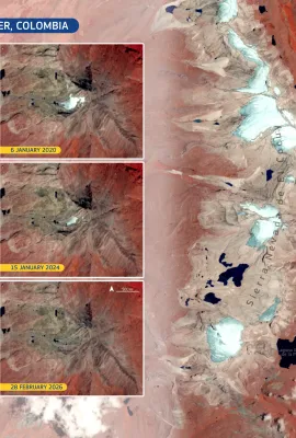
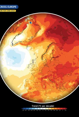
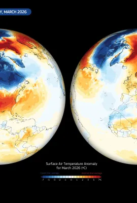
European Union flag
EU Space Policy

Explore EU Space

Results (1080)
Image of the Day
Floods in the Lazio Region, Italy
Earth Observation | Copernicus
In early January 2026, severe rainfall affected the Lazio region in Italy, with river levels rising rapidly in several areas. As a result, regional and national civil protection authorities issued red alerts where precipitation was most intense. This Copernicus Sentinel-1 image, acquired by one of the Copernicus Sentinel-1 satellites on 6...
Image of the Day
Cyprus, the Island of Aphrodite from above
Earth Observation | Copernicus
Cyprus, the third-largest island in the Mediterranean Sea, is characterised by a diverse landscape shaped by mountains, plains, and an extensive coastline. Despite its semi-arid climate, the island supports a mosaic of ecosystems, including forested areas in the Troodos Mountains, agricultural lowlands, and coastal wetlands which provide...
Image of the Day
First eruption of Mount Etna in 2026
Earth Observation | Copernicus
On 1 January 2026, Mount Etna entered a new eruptive phase, with lava emerging from a fissure vent located approximately 2,000- 2,100 metres above sea level in the Valle del Bove. According to Italy’s National Institute of Geophysics and Volcanology (INGV), no residential areas were at immediate risk, and no infrastructural damage has been...
Image of the Day
Snowfall leads to disruptions in the Netherlands
Earth Observation | Copernicus
In early January 2026, heavy snowfall and icy conditions affected large parts of the Netherlands, triggering a severe weather alert in several provinces. The widespread snow cover led to major disruptions, including long traffic tailbacks, hazardous road conditions, and hundreds of cancelled or delayed flights at Schiphol Airport. Rail services...
Image of the Day
Mountain ecosystems of Greenland
Earth Observation | Copernicus
Greenland’s mountains are crucial for shaping regional climate patterns, influencing ice-sheet dynamics, and directing meltwater to the coast. They also host some of the world’s largest outlet glaciers, which channel ice from the interior towards the ocean and play a key role in sea level rise. In this Copernicus Sentinel-2 satellite image,...
Image of the Day
Zeebrugge, Belgium
Earth Observation | Copernicus
On 3 December 2025, waters along Belgium’s North Sea coast showed clear colour contrasts, revealing active sediment dynamics driven by tidal currents and shallow bathymetry. Such conditions favour the frequent resuspension of sediments, leading to spatially variable turbidity along the coast. This image, acquired on 3 December 2025 by one of...
Image of the Day
São Paulo as seen from space
Earth Observation | Copernicus
São Paulo is the largest city in Brazil and a key economic hub in Latin America. Located in the south-eastern region of the country, it serves as the capital of the state of São Paulo. The city has undergone rapid urban growth in recent decades, resulting in a vast metropolitan area characterised by high population density, extensive...
Image of the Day
Sal Island, Cape Verde
Earth Observation | Copernicus
Sal Island, part of the Cape Verde archipelago in the eastern Atlantic Ocean, is characterised by a flat, arid landscape shaped by volcanic origins and persistent trade winds. The island and its marine surroundings host fragile ecosystems, including coral reefs, salt flats, and nesting sites for seabirds and marine turtles. These environments...
Image of the Day
Top 5 Images of The Day in 2025
Earth Observation | Copernicus
2025 represented an unprecedented year for the EU Space Programme, particularly regarding the expansion of the Copernicus Sentinel family. Europe achieved a notable pace of satellite deployments, with the successful launches of Sentinel-4A, Sentinel-5A, Sentinel-1D, and Sentinel-6B. In parallel with these milestones, the Copernicus Image of the...
Image of the Day
Daugavpils, Latvia
Earth Observation | Copernicus
Daugavpils, Latvia’s second-largest city, lies to the south-east of the country and has long served as a key regional centre. Its development and identity are closely tied to the Daugava River, which flows through the city, shaping both the landscape and local life. Along its banks, forests, wetlands, and floodplains support diverse wildlife,...
Image of the Day
The arctic wetlands of the Teshekpuk Lake, Alaska, USA
Earth Observation | Copernicus
The Teshekpuk Lake Special Area, situated on Alaska’s North Slope, is one of the most ecologically important Arctic wetland systems in North America. Recognised for its high conservation value, the area encompasses extensive tundra landscapes shaped by permafrost, shallow lakes, and wetlands. These habitats are important for migratory birds,...
Image of the Day
The retreat of the Breiðamerkurjökull glacier, Iceland
Earth Observation | Copernicus
Iceland’s glaciers are among the most prominent in Europe and play an important role in regulating freshwater resources and sea level contribution. In recent decades, they have shown sustained retreat and thinning, reflecting rising air temperatures and changing precipitation patterns associated with climate change, trends that are closely...
Image of the Day
The Istrian Peninsula
Earth Observation | Copernicus
The Istrian Peninsula, the largest peninsula in the Adriatic Sea, is a region of high ecological value. It hosts a mosaic of karst hills, coastal wetlands, and productive marine habitats which support diverse wildlife. Its rugged shoreline, dotted with islands and bays, provides important breeding and feeding grounds for fish and seabirds,...
Image of the Day
Smallest and shortest-lived ozone hole in 5 years closes
Earth Observation | Copernicus
The 2025 Antarctic ozone hole closed on 1 December, marking the earliest closure since 2019. This year’s ozone hole was also relatively small for the second consecutive year, especially when compared to the larger and more persistent ozone holes observed between 2020 and 2023. It also exhibited higher ozone concentrations, raising hopes for...
Image of the Day
Valdivia, Chile
Earth Observation | Copernicus
Located in southern Chile’s Los Ríos Region, the city of Valdivia has been internationally designated under the Ramsar Convention as Latin America’s first “Wetland City”. The recognition comes after decades of citizen driven action to protect the city’s rivers, floodplains and coastal wetlands, which provide habitats for wildlife and act as...
Image of the Day
2024 wildfires in Europe
Earth Observation | Copernicus
The recently published Forest Fires in Europe, Middle East and North Africa 2024 Report, based on data from the European Forest Fire Information System (EFFIS), indicates that although last year’s fire season was classified as a moderate wildfire year for the EU, it remained above the 17-year average. This data visualisation shows the...
Image of the Day
Arctic sea ice extent at record low levels
Earth Observation | Copernicus
After reaching the second-lowest extent on record in November 2025, sea ice extent in the Arctic remained unusually low into December. Data from the EUMETSAT Ocean and Sea Ice Satellite Application Facility (OSI SAF) show that, at the beginning of December 2025, Arctic sea ice extent was the lowest observed for this time of year. On 17...
Image of the Day
Drought on the Iberian Peninsula
Earth Observation | Copernicus
In autumn 2025, persistently warm conditions combined with limited rainfall led to persistent drought conditions across the Iberian Peninsula. As rainfall deficits accumulated, soil moisture levels declined and water availability decreased, increasing pressure on agriculture, natural ecosystems, and water resources.  This data visualisation,...
Image of the Day
Mapping agricultural diversity around Prague
Earth Observation | Copernicus
The agricultural landscape surrounding Prague reflects the long-standing importance of farming in the Czech Republic, where arable land supports both national food production and rural livelihoods. This region is characterised by large, intensively managed fields interspersed with forests, urban areas, and other agricultural zones.  This data...
Image of the Day
La Niña cooling pattern in the Pacific Ocean
Earth Observation | Copernicus
La Niña is a naturally occurring climate phenomenon characterised by cooler-than-average sea surface temperatures in the central and eastern equatorial Pacific Ocean. It is part of the El Niño–Southern Oscillation (ENSO) cycle and significantly influences global weather patterns. By altering atmospheric circulation, La Niña can lead to...

Showing 81-100 of 1080 results