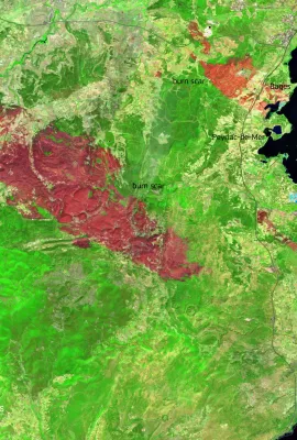
European Union flag
EU Space Policy

Explore EU Space

Results (1168)
Image of the Day
Flooding across the Punjab plains, Pakistan
Earth Observation | Copernicus
Recent heavy monsoon rains in Pakistan’s Punjab region have caused the Sutlej, Chenab, and Ravi rivers to overflow. Hundreds of thousands of people and nearly 2,000 villages have been affected by disruptions in access to electricity and clean water. This satellite image, acquired by one of the Copernicus Sentinel-2 satellites on 9 September...
Image of the Day
Wildfire burn scars along the Spain–Portugal border
Earth Observation | Copernicus
In August 2025, multiple wildfires broke out along the border between Spain and Portugal, affecting natural parks and municipalities, particularly in Galicia and León.  As visible in this false-colour image, acquired by one of the Copernicus Sentinel-2 satellites on 5 September 2025, the most affected areas are concentrated around the...
Image of the Day
The Galápagos National Park, Ecuador
Earth Observation | Copernicus
The Galápagos National Park, created in 1959, protects 97% of the islands’ unique wildlife, including giant tortoises and marine iguanas. A UNESCO World Heritage Site, it balances conservation with sustainable tourism and inspired Charles Darwin’s theory of evolution. This artistic impression of the Marchena Island, part of the Galapagos...
Image of the Day
August 2025, the third-warmest August on record globally
Earth Observation | Copernicus
The Copernicus Climate Change Service (C3S) has published its latest monthly Climate Bulletin, focused on key climate trends in August 2025. The bulletin reports that August 2025 was the third-warmest August globally, with an average ERA5 surface air temperature of 16.60°C. This was 0.49°C above the 1991–2020 average for the month and 1.29°C...
Image of the Day
The dynamic Lafnitz River, Austria
Earth Observation | Copernicus
Flowing through meandering stretches in south-eastern Austria, the Lafnitz is a dynamic lowland river where erosion and sedimentation continually reshape its middle and lower reaches. Its landscapes include sandbanks, islets, oxbow lakes, deep pools, and diverse vegetation such as gallery woods, alder–ash floodplain forests, dead timber, and...
Image of the Day
Ballypatrick Forest, Northern Ireland (UK)
Earth Observation | Copernicus
Ballypatrick Forest, in County Antrim, Northern Ireland (United Kingdom), lies within the rugged Antrim Plateau. The landscape features conifer plantations, mainly Sitka spruce, intermixed with heathland and blanket bogs.  Conservation efforts in recent years have focused on reforestation, habitat restoration, and protecting local wildlife,...
Image of the Day
Lake Tisza, Hungary
Earth Observation | Copernicus
Lake Tisza, located in eastern Hungary, is the country’s second-largest lake. Spanning approximately 127 square kilometres, it is known for its diverse ecosystems and popularity for activities such as fishing, boating, and birdwatching. The surrounding wetlands serve as a habitat for numerous bird species, making it a key area for conservation...
Image of the Day
The Étang de Montady
Earth Observation | Copernicus
The Étang de Montady, located in southern France near the town of Montady, is a remarkable example of medieval land reclamation. Originally a wetland, it was drained in the 13th century using a radial system of ditches converging at a central collection point. This ingenious hydraulic design transformed the area into fertile farmland and...
Image of the Day
The Žuvinto, Žaltycio ir Amalvo pelkes wetland areas, Lithuania
Earth Observation | Copernicus
This Copernicus Sentinel-2 image, acquired on 5 September 2024, shows the Žuvinto, Žaltycio ir Amalvo pelkes wetland areas, a Natura 2000 site in Lithuania. Spanning an area over 18,000 hectares, this site is home to 17 EU protected bird species. The European Commission, through the LIFE Programme, is supporting the implementation of the...
Image of the Day
Tunis, Tunisia
Earth Observation | Copernicus
Tunis, the capital of Tunisia, lies between the Mediterranean coast and a network of coastal lagoons and wetlands. The largest of these is Lake Tunis, divided into northern and southern basins, along with the smaller Sebkha Sijoumi to the south-west. Some of these wetlands are protected under the Ramsar Convention and serve as important...
Image of the Day
Aalborg from above
Earth Observation | Copernicus
Aalborg, one of Denmark’s key northern cities, lies along the Limfjord, a shallow sound connecting the North Sea to the Kattegat strait. The city blends urban development with surrounding farmland and natural waterways. This Copernicus Sentinel-2 image from 12 February 2021 highlights the path of the frozen Limfjord through the city. Urban...
Image of the Day
Uluru, Australia
Earth Observation | Copernicus
Uluru, also known as Ayers Rock, is a massive sedimentary rock formation located in the heart of Australia’s Northern Territory. Rising 348 metres above the surrounding plain, Uluru is not only a striking natural landmark but also holds deep spiritual significance for the Anangu people. Estimated to be over 500 million years old, this UNESCO...
Image of the Day
World Lake Day: Lake Suchitlan, El Salvador
Earth Observation | Copernicus
27 August is the first-ever World Lake Day, dedicated to tracking and protecting the health of millions of lakes around the globe.  This Copernicus Sentinel-2 image from 13 August 2025 shows Lake Suchitlan, El Salvador’s largest wetland reservoir and a key source of the country’s hydropower. In the image, the green colouring on the lake’s...
Image of the Day
Visualising population density with Copernicus data
Earth Observation | Copernicus
The Copernicus Emergency Management Service Global Human Settlement Layer (GHSL) provides detailed mapping of human presence around the world. This data enables urban planners, researchers, and policymakers to assess demographic distribution, infrastructure needs, and urban expansion trends, supporting informed decisions for sustainable city...
Image of the Day
The image shows the island of Amorgos, Greece.
Earth Observation | Copernicus
Amorgos, the easternmost island of the Cyclades, seems to guard the nearby Small Cyclades with its oblong shape. It stands at the centre of the Southern Aegean Sea, acting as a crossroads where the North meets the South.  Rising dramatically above the sea, parts of Amorgos offer sweeping ocean views. This striking Cycladic Island features...
Image of the Day
The Motagua River, Guatemala
Earth Observation | Copernicus
Stretching over 480 kilometres from the Guatemalan highlands to the Caribbean Sea, the Motagua River is one of the most important waterways in Central America. It winds through diverse landscapes, from rugged mountains to fertile plains, supporting agriculture, fisheries, and numerous communities. For centuries, the river has served as a vital...
Image of the Day
The images shows the ice in white and changes in ice and sea ice in rainbow colours
Earth Observation | Copernicus
This striking composite image of Greenland’s south-eastern coast was created from three Copernicus Sentinel-1 radar acquisitions on 31 January, 8 March, and 20 March 2025.  The multicolour patterns along the fjords and ice fronts highlight dynamic changes in ice and sea ice positions, with the rainbow-like interference showing how far ice has...
Image of the Day
the image shows smoke plumes from active fires near the city of Ourense, located in the autonomous community of Galicia, northwestern Spain. 
Earth Observation | Copernicus
Massive wildfires are spreading in north-west and western Spain, forcing the evacuation of thousands of residents.   By 17 August 2025, Spain had already recorded its highest annual total of estimated fire emissions in the 23-year Copernicus Atmosphere Monitoring Service (CAMS) dataset.   This Copernicus Sentinel-2 image acquired on 16 August...
Image of the Day
Burn scar in red from wildfires in the Aude region in France
Earth Observation | Copernicus
A devastating wildfire in France's Aude region, started on 5 August 2025, has become the country's most severe in nearly 80 years, burning over 17,000 hectares, an area larger than Paris. The fire's rapid spread was exacerbated by drought conditions, dry vegetation, and strong winds.  This image, acquired by one of the Copernicus Sentinel-2...
Image of the Day
the image shows Noordwijk in the Netherlands and the Dutch North Sea coast
Earth Observation | Copernicus
Noordwijk, located on the Dutch North Sea coast, is home to stunning landscapes, including 13 kilometres of sandy beaches. The town boasts tall sand dunes and lush forests, which provide a relaxing atmosphere for outdoor activities. It also serves as an important hub for the EU Space Programme, hosting the Galileo Reference Centre.  This image,...

Showing 261-280 of 1168 results