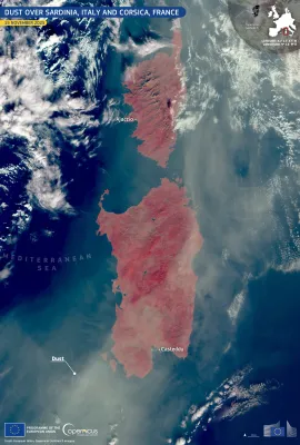
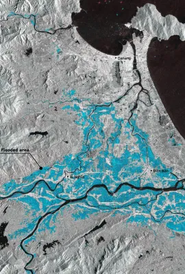
Ballypatrick Forest, in County Antrim, Northern Ireland (United Kingdom), lies within the rugged Antrim Plateau. The landscape features conifer plantations, mainly Sitka spruce, intermixed with heathland and blanket bogs. Conservation efforts in recent years have focused on reforestation, habitat restoration, and protecting local wildlife,...
Results (1080)
Lake Tisza, located in eastern Hungary, is the country’s second-largest lake. Spanning approximately 127 square kilometres, it is known for its diverse ecosystems and popularity for activities such as fishing, boating, and birdwatching. The surrounding wetlands serve as a habitat for numerous bird species, making it a key area for conservation...
The Étang de Montady, located in southern France near the town of Montady, is a remarkable example of medieval land reclamation. Originally a wetland, it was drained in the 13th century using a radial system of ditches converging at a central collection point. This ingenious hydraulic design transformed the area into fertile farmland and...
This Copernicus Sentinel-2 image, acquired on 5 September 2024, shows the Žuvinto, Žaltycio ir Amalvo pelkes wetland areas, a Natura 2000 site in Lithuania. Spanning an area over 18,000 hectares, this site is home to 17 EU protected bird species. The European Commission, through the LIFE Programme, is supporting the implementation of the...
Tunis, the capital of Tunisia, lies between the Mediterranean coast and a network of coastal lagoons and wetlands. The largest of these is Lake Tunis, divided into northern and southern basins, along with the smaller Sebkha Sijoumi to the south-west. Some of these wetlands are protected under the Ramsar Convention and serve as important...
Aalborg, one of Denmark’s key northern cities, lies along the Limfjord, a shallow sound connecting the North Sea to the Kattegat strait. The city blends urban development with surrounding farmland and natural waterways. This Copernicus Sentinel-2 image from 12 February 2021 highlights the path of the frozen Limfjord through the city. Urban...
Uluru, also known as Ayers Rock, is a massive sedimentary rock formation located in the heart of Australia’s Northern Territory. Rising 348 metres above the surrounding plain, Uluru is not only a striking natural landmark but also holds deep spiritual significance for the Anangu people. Estimated to be over 500 million years old, this UNESCO...
27 August is the first-ever World Lake Day, dedicated to tracking and protecting the health of millions of lakes around the globe. This Copernicus Sentinel-2 image from 13 August 2025 shows Lake Suchitlan, El Salvador’s largest wetland reservoir and a key source of the country’s hydropower. In the image, the green colouring on the lake’s...
The Copernicus Emergency Management Service Global Human Settlement Layer (GHSL) provides detailed mapping of human presence around the world. This data enables urban planners, researchers, and policymakers to assess demographic distribution, infrastructure needs, and urban expansion trends, supporting informed decisions for sustainable city...
Amorgos, the easternmost island of the Cyclades, seems to guard the nearby Small Cyclades with its oblong shape. It stands at the centre of the Southern Aegean Sea, acting as a crossroads where the North meets the South. Rising dramatically above the sea, parts of Amorgos offer sweeping ocean views. This striking Cycladic Island features...
Stretching over 480 kilometres from the Guatemalan highlands to the Caribbean Sea, the Motagua River is one of the most important waterways in Central America. It winds through diverse landscapes, from rugged mountains to fertile plains, supporting agriculture, fisheries, and numerous communities. For centuries, the river has served as a vital...
This striking composite image of Greenland’s south-eastern coast was created from three Copernicus Sentinel-1 radar acquisitions on 31 January, 8 March, and 20 March 2025. The multicolour patterns along the fjords and ice fronts highlight dynamic changes in ice and sea ice positions, with the rainbow-like interference showing how far ice has...
Massive wildfires are spreading in north-west and western Spain, forcing the evacuation of thousands of residents. By 17 August 2025, Spain had already recorded its highest annual total of estimated fire emissions in the 23-year Copernicus Atmosphere Monitoring Service (CAMS) dataset. This Copernicus Sentinel-2 image acquired on 16 August...
A devastating wildfire in France's Aude region, started on 5 August 2025, has become the country's most severe in nearly 80 years, burning over 17,000 hectares, an area larger than Paris. The fire's rapid spread was exacerbated by drought conditions, dry vegetation, and strong winds. This image, acquired by one of the Copernicus Sentinel-2...
Noordwijk, located on the Dutch North Sea coast, is home to stunning landscapes, including 13 kilometres of sandy beaches. The town boasts tall sand dunes and lush forests, which provide a relaxing atmosphere for outdoor activities. It also serves as an important hub for the EU Space Programme, hosting the Galileo Reference Centre. This image,...
The Giza Plateau, located on the western edge of Greater Cairo, Egypt, is home to some of the most iconic monuments of the ancient world. Foremost among them is the Pyramid of Khufu, also known as the Great Pyramid of Giza, the last surviving wonder of the ancient world and a UNESCO World Heritage site. Constructed over 4,500 years ago, these...
Following the launch of Copernicus Sentinel-4A last month, the European Union successfully launched the Copernicus Sentinel-5A to further monitor air quality and emissions around the world. The satellite lifted off from the Europe’s Spaceport in Kourou, French Guiana at 02:37am (CEST) onboard Ariane 62 rocket and sent its first signal to Earth...
The Mayon Volcano, located in Albay province on Luzon Island in the Philippines, is one of the most active stratovolcanoes in the world. Rising 2,462 metres above sea level, it is part of the Pacific Ring of Fire and a designated protected landscape under the Philippine National Integrated Protected Areas System. Its fertile slopes support...
Copenhagen, the capital of Denmark, is located on the islands of Zealand (Sjælland) and Amager. City authorities are working to make it the world’s first carbon-neutral capital by 2025. This commitment to sustainability is reflected in the city’s bike lanes, abundant urban green spaces, and widespread green roofs, all of which are visible in...
Located in north-western Madagascar, Ankarafantsika National Park is a key stronghold for the island’s unique dry deciduous forests, among the most threatened ecosystems in the region. Designated as a protected area, the park supports an extraordinary range of endemic wildlife, including eight species of lemurs, rare reptiles, and over 120 bird...
Showing 201-220 of 1080 results