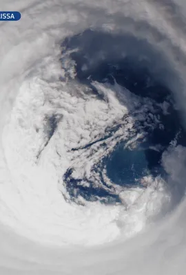
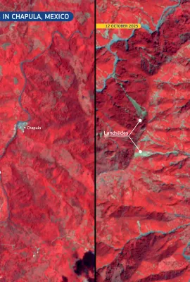
European Union flag
EU Space Policy

Explore EU Space

Results (1173)
Image of the Day
Copernicus Sentinel-6: measuring sea levels from space
Earth Observation | Copernicus
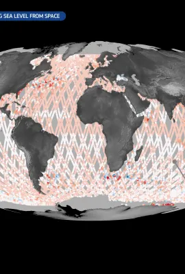
The Copernicus Sentinel-6 satellite mission is the global reference for measuring sea surface height. The first satellite of the mission, Copernicus Sentinel-6 Michael Freilich (Sentinel-6A), was launched in 2020. It follows a well-established, 10-day repeat orbit, delivering sea-level measurements with centimetre-level accuracy. Data from...
Image of the Day
Sentinel-2 captures a vivid view of hurricane Melissa's eye
Earth Observation | Copernicus
On 28 October 2025, Hurricane Melissa, the most powerful storm to hit Jamaica in history, made landfall on the island with devastating force. With sustained winds reaching 298 km/h and a central pressure of 892 hPa, Melissa already ranks among the most intense hurricanes ever observed in the Atlantic basin. On that day, at 15:55 UTC, one of the...
Image of the Day
20251029_Eye Hurricane Melissa
Earth Observation | Copernicus
On 28 October 2025, Hurricane Melissa, the most powerful storm to hit Jamaica in history, made landfall on the island with devastating force. With sustained winds reaching 298 km/h and a central pressure of 892 hPa, Melissa already ranks among the most intense hurricanes ever observed in the Atlantic basin.
Image of the Day
Mont Idoukal-n-Taghès, Niger
Earth Observation | Copernicus
Rising to 2,022 metres, Mont Idoukal-n-Taghès is the highest peak in Niger and a prominent feature of the Aïr Massif in the north of the country. This mountainous region of volcanic origin stands out as a biodiversity hotspot within the arid expanse of the southern Sahara. This natural-colour image, acquired on 8 September 2025 by one of the...
Image of the Day
Hurricane Melissa
Earth Observation | Copernicus
After forming in the central Atlantic Ocean at the end of October 2025, Hurricane Melissa underwent rapid intensification as it moved westward across the Atlantic, reaching Category 4 status with sustained winds of 225 km/h. The storm then began to move west-north-west, passing through the Greater Antilles and severely affecting the Dominican...
Image of the Day
Sediments along the coast of eastern Iceland
Earth Observation | Copernicus
With a length of around 150 km, the Jökulsá á Dal is among Iceland’s longest rivers. It carries meltwater and sediments from Vatnajökull, Europe’s largest glacier, across the eastern highlands. The Jökulsá á Dal river flows into Lagarfljót Lake, a long and narrow waterbody uniquely classified as both a river and a lake, before reaching the...
Image of the Day
Devastating landslides and flooding in Chapula, Mexico
Earth Observation | Copernicus
In October 2025, large parts of central and eastern Mexico have faced severe flooding, triggered by torrential rainfall from converging tropical storms. According to local authorities, there have been at least 64 reported casualties, with dozens of people missing. The village of Chapula has been particularly impacted by landslides and flooding...
Image of the Day
Geneva from Above: Celebrating 80 Years of the United Nations
Earth Observation | Copernicus
24 October 2025 is United Nations Day, marking 80 years since the United Nations Charter came into force. As the cornerstone of international cooperation, the United Nations plays a vital role in promoting peace, protecting human rights, and advancing global sustainable development.  This striking true-colour image acquired by one of the...
Image of the Day
Floods on Panay Island, the Philippines
Earth Observation | Copernicus
Extensive flooding swept across Panay Island in the Philippines following heavy rains from Tropical Storm Ramil on 18 October 2025. The storm brought record-breaking rainfall, with Roxas City receiving up to 365.5 mm in just 24 hours – more than a month's worth of precipitation in a single day. According to local authorities, over...
Image of the Day
The unique floating islands of Loktak Lake, India
Earth Observation | Copernicus
Loktak Lake, located in the state of Manipur, is the largest freshwater lake in north-eastern India, renowned for its floating islands known as phumdis: masses of vegetation, soil, and organic matter which support both human settlements and diverse ecosystems. The lake plays a crucial role in the local economy by supporting fishing,...
Image of the Day
First image of nitrogen dioxide from Copernicus Sentinel-4
Earth Observation | Copernicus
The new Copernicus Sentinel-4 mission has delivered its first images, highlighting concentrations of atmospheric nitrogen dioxide, sulphur dioxide and ozone.  This image, based on the Sentinel-4 very first measurements acquired on 8 October 2025, depicts tropospheric nitrogen dioxide with clear pollution hotspots visible along the Mediterranean...
Image of the Day
The impact of drought on Lake Mornos, Greece
Earth Observation | Copernicus
Lake Mornos is an artificial reservoir in central Greece, serving as a primary water source for Athens. According to national authorities, the lake has lost nearly half of its water volume  over the past four years, decreasing its surface water extent from around 19.1 km² in early 2022 to 8.7 km² by September 2025. The decrease in the lake’s...
Image of the Day
The Folgefonna Glacier, Norway
Earth Observation | Copernicus
Covering 207 square kilometres and reaching thicknesses of nearly 400 metres, Folgefonna is the third-largest glacier on mainland Norway. For nearly two centuries, this striking natural landmark has drawn tourists to the region for activities such as hiking and skiing. However, due to ongoing ice thinning, researchers estimate that the...
Image of the Day
Coipasa Salar, Bolivia
Earth Observation | Copernicus
Located next to the Chilean border in the Altiplano region of Bolivia, Coipasa Salar is Bolivia’s second largest salt lake, spanning over 2,000 square kilometres.  Coipasa Salar is rich in deposited minerals and provides essential habitat for flamingo species which settle on the saline shores. This false-colour image from 6 October 2025,...
Image of the Day
September 2025: Arctic and Antarctic sea ice reach their annual minimum and maximum extents, respectively
Earth Observation | Copernicus
Each September marks the end of the polar summer in the Arctic, when sea ice reaches its annual minimum extent. At the same time, the Antarctic emerges from the austral winter, reaching its annual maximum sea ice extent. These cycles are essential to the Earth's climate system, illustrating how each hemisphere responds to seasonal heating and...
Image of the Day
Fog over the Austrian alpine valleys
Earth Observation | Copernicus
Nestled within the heart of the Eastern Alps, the Austrian mountain valleys are vital ecological corridors, home to diverse alpine habitats and species specially adapted to cold climates and steep terrain. Fog is common in this region, especially in autumn and winter, forming when cold air settles in valleys overnight. Moisture condenses near...
Image of the Day
Autumn colours in the Apennines, Italy
Earth Observation | Copernicus
This Copernicus Sentinel-2 image, acquired on 11 October 2025, shows the hills and valleys between the Tuscany and Emilia-Romagna regions of central-northern Italy in stunning autumnal tones. The forests display a rich palette of colours ranging from deep green to warm red and ochre as the tree canopies change in response to shorter days and...
Image of the Day
Severe flooding in Thái Nguyên, Vietnam
Earth Observation | Copernicus
Beginning on 6 October 2025, severe flooding swept through parts of northern Vietnam, reaching the highest water levels recorded in three major rivers in the past 40 years. The floods have resulted in at least eight casualties and forced the evacuation of many residents across the region. According to local authorities, around 30,000 personnel...
Image of the Day
September 2025 was the third-warmest September on record globally
Earth Observation | Copernicus
The Copernicus Climate Change Service (C3S) has published its latest monthly Climate Bulletin, focused on key climate trends in September 2025.  The bulletin reports that September 2025 was the third-warmest September ever globally, with an average ERA5 surface air temperature of 16.11°C, which is 0.66°C above the 1991–2020 average for the...
Image of the Day
Peatlands in Estonia
Earth Observation | Copernicus
The Pärnu River catchment on Estonia’s western coastline is home to over 3,500 hectares of peatland, contributing to Estonia’s status as one of the most peat-rich countries in the world.  Peat, which forms in bogs and fens through the incomplete decomposition of organic material, makes up the world’s largest terrestrial store of organic carbon....

Showing 221-240 of 1173 results