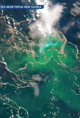
European Union flag
EU Space Policy

Explore EU Space

Results (1987)
Image of the Day
Graham Land, Antarctica
Earth Observation | Copernicus
Graham Land, the northernmost stretch of the Antarctic Peninsula, is one of the most rapidly warming regions on Earth. Its mountainous spine and outlet glaciers drain into the Weddell Sea, forming an important transition zone between grounded ice, floating shelves, and open water. This dynamic landscape supports rich marine ecosystems,...
Image of the Day
Shark Bay, Australia, a UNESCO World Heritage Site
Earth Observation | Copernicus
Shark Bay, located on the western coast of Australia, is a UNESCO World Heritage Site renowned for its exceptional natural beauty, including unique marine biodiversity and one of the world's most extensive seagrass beds. The site is globally significant for its ecological processes, geological formations, and as a habitat for threatened species...
Image of the Day
Gulf of Morbihan, France
Earth Observation | Copernicus
The Gulf of Morbihan, part of the Natura 2000 network, forms one of France’s most distinctive coastal landscapes. This inland sea is dotted with dozens of small islands and peninsulas, creating a labyrinth of sheltered bays, narrow channels, and shifting tidal flats. Its highly indented shape supports a mosaic of coastal habitats, from eelgrass...
Image of the Day
Snow on the High-Atlas Mountains
Earth Observation | Copernicus
Early winter in north-western Africa is marked by the arrival of Atlantic weather systems that bring cooler air, increased cloud cover, and the first significant precipitation of the season. As these systems interact with the region’s varied terrain, they frequently produce episodes of heavy rain in lowland areas and snowfall across the...
Image of the Day
Settlement growth in the Nile Delta, Egypt
Earth Observation | Copernicus
The United Nations’ World Urbanisation Prospects 2025 was published on 17 November 2025. Drawing on data from the Joint Research Centre’s Global Human Settlement Layer (GHSL), developed under the Copernicus Emergency Management Service (CEMS), the report tracks changes in population distribution across more than 12,000 urban settlements. It...
Image of the Day
Floods in Sri Lanka
Earth Observation | Copernicus
Torrential rainfall associated with Cyclone Ditwah, which made landfall on Sri Lanka’s eastern coast on 28 November 2025, resulted in extensive flooding across the country. The event caused at least 410 casualties, with 336 people reported missing. The Copernicus Emergency Management Service (CEMS) was activated (EMSR851) to assess the extent...
Image of the Day
Flooding in northern Sumatra, Indonesia
Earth Observation | Copernicus
Cyclone Senyar formed during the night of 25-26 November 2025 in the Strait of Malacca, an area in which tropical cyclones had not been recorded for decades. The day after its formation, Senyar hit Indonesia, where it made landfall, causing flooding, landslides and more than 400 casualties in the north of the island of Sumatra.  This image,...
Image of the Day
Cluj-Napoca, Romania
Earth Observation | Copernicus
On 17 October 2025, one of the Copernicus Sentinel-2 satellites acquired this image of Cluj-Napoca, a major urban centre in north-western Romania. Surrounded by rolling hills and agricultural land, the city is noted for its dynamic growth and strategic role in regional development. Cluj-Napoca also received the label of the EU Mission for...
Image of the Day
The Bolivian Altiplano
Earth Observation | Copernicus
The Bolivian Altiplano, part of the vast Andean plateau, is among the highest inhabited regions on Earth. This arid landscape is characterised by deep canyons, colourful sedimentary formations, and rugged ridgelines shaped over millennia by wind and water erosion. This false-colour image, acquired on 1 January 2025 by one of the Copernicus...
Image of the Day
Huelva estuary, Spain
Earth Observation | Copernicus
On 16 November 2025, one of the Copernicus Sentinel-2 satellites acquired this image of the Huelva estuary in south-western Spain, where the Tinto and Odiel rivers converge before flowing into the Atlantic Ocean.  Recent rainfall has increased surface runoff and sediment transport, strengthening the contrasting outflow from the two rivers. The...
Image of the Day
The new morphology of the Hayli Gubbi volcano
Earth Observation | Copernicus
On 23 November 2025, the Hayli Gubbi volcano in north-eastern Ethiopia erupted for the first time in recorded history. The volcano is located in the seismically active Afar Depression, part of the African Rift fault system. The event generated an ash and gas column reaching approximately 13–15 km, and the ash cloud spread over the Red Sea...
Image of the Day
Snow blanketed North East Scotland
Earth Observation | Copernicus
On 18 November 2025, the first major winter weather event of the 2025-26 season took place across parts of the United Kingdom, including north-east Scotland. Heavy snowfall blanketed large areas of the region, leading to travel disruption, the isolation of several rural communities, and the closure of numerous schools. Emergency services were...
News
OBSERVER: The evolution of the EU Space Networks
Earth Observation | Copernicus
The EU Space Networks have grown from more than a decade of EU-funded activities which explored how to bring satellite data closer to users. These early efforts evolved into the Copernicus Academy and Copernicus Relays, which would eventually grow to more than 300 members worldwide. Their success in supporting Copernicus user uptake inspired...
Image of the Day
First images from Copernicus Sentinel-5A
Earth Observation | Copernicus
Copernicus Sentinel-5A has delivered its first images after its launch on 13 August 2025, marking a significant milestone in the monitoring of air quality from space. The Sentinel-5 mission provides observations of key air pollutants, essential climate variables, and stratospheric ozone, which is the protective layer shielding life on Earth...
Image of the Day
First images acquired by Sentinel-1D
Earth Observation | Copernicus
Following its launch on 4 November 2025, Copernicus Sentinel-1D has delivered its first images. Among these is this radar image acquired on 7 November 2025, showing northern Germany. The false colour visualisation of the image highlights different types of land cover such as cultivated fields, water bodies, and urban areas, including the cities...
Image of the Day
Eruption of Hayli Gubbi volcano, Ethiopia
Earth Observation | Copernicus
On 23 November 2025, the Hayli Gubbi volcano in Ethiopia, located approximately 800 kilometres north-east of Addis Ababa, erupted for the first time in nearly 12,000 years.  As a result of the eruption, a large sulfur dioxide (SO₂) plume was emitted into the atmosphere. This image, derived from data acquired by the Copernicus Sentinel-5P...
Image of the Day
Autumn colours across Honshu Island, Japan
Earth Observation | Copernicus
Every autumn, as temperatures fall and daylight hours shorten across Japan, the country enters its annual kōyō season, when the combination of reduced sunlight and cooler temperatures triggers the transition of tree leaves from green to autumnal reds and browns.  This Copernicus Sentinel-2 image from 17 November 2025 shows widespread autumn...
Image of the Day
Eastern Greenland at the start of winter
Earth Observation | Copernicus
As winter approaches in the Northern Hemisphere, reduced sunlight at high latitudes leads to colder temperatures and the formation of sea ice along the eastern coast of Greenland. This Copernicus Sentinel-2 image, acquired on 13 November 2025, shows the region illuminated in the soft light of a low sun, which creates elongated shadows across...

Showing 141-160 of 1987 results