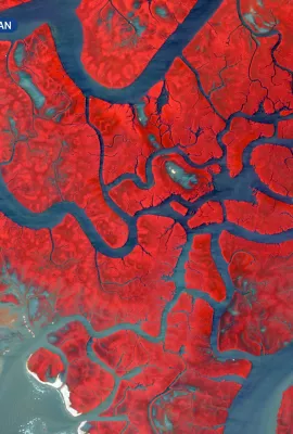
European Union flag
EU Space Policy

Explore EU Space

Results (1987)
Image of the Day
Wildfire in the Tongariro National Park, New Zealand
Earth Observation | Copernicus
On 8 November 2025, a wildfire swept through nearly 3,000 hectares of alpine ecosystem in the Tongariro National Park, New Zealand. The fire damaged important habitats for native species on the North Island. Teams from the Department of Conservation, with support from Fire and Emergency New Zealand, fully contained the fire, and restoration...
Image of the Day
Floods in northern Italy
Earth Observation | Copernicus
On 18 November 2025, intense flooding and a devastating landslide struck the Friuli Venezia Giulia region in northern Italy following prolonged, intense rainfall. The area surrounding the towns of Gorizia and Romans d’Isonzo were affected by significant inundation, with rivers overtopping their banks and submerging adjacent lowlands.   This...
Image of the Day
Flooding in Ireland after Storm Claudia
Earth Observation | Copernicus
On 14 November 2025, Storm Claudia swept across Ireland, bringing severe weather conditions and significant flooding to the Leinster and Munster provinces. The Copernicus Emergency Management Service (CEMS) was activated (EMSR849) to assess the extent and impact of flooding in the affected regions.  This data visualisation, obtained using the...
Image of the Day
Offshore wind farms in the North Sea
Earth Observation | Copernicus
The acceleration of the clean energy transition across Europe offshore wind farms has made offshore wind farms essential for reducing greenhouse gas emissions and ensuring a more sustainable future.  In this Copernicus Sentinel-1 radar image, acquired on 15 October 2025, clusters of wind turbines appear as bright, structured formations on the...
Image of the Day
Dust over Sardinia, Italy and Corsica, France
Earth Observation | Copernicus
On 14 November, a dust storm originating in North Africa swept across the western Mediterranean.  This Copernicus Sentinel-3 image, acquired on 15 November, clearly shows the phenomenon: a thick layer of Saharan dust stretches northwards, partially obscuring the islands of Sardinia (to the south and Corsica to the north). The reddish tones over...
Image of the Day
Successful launch of Copernicus Sentinel-6B
Earth Observation | Copernicus
Copernicus Sentinel-6B was successfully launched earlier this morning at 06:21 CET from Vandenberg Base in California. The satellite sent its first signal down to Earth at 07:54, confirming that it is healthy. This radar altimetry satellite, developed through a partnership between the European Commission, the European Space Agency (ESA), the...
Image of the Day
The Ganges River, India
Earth Observation | Copernicus
This image, acquired one of the Copernicus Sentinel-2 satellites on 25 October 2025, shows a meandering stretch of the Ganges River in eastern India. Flowing through the district of Sahibganj in the state of Jharkhand, the river exhibits a dynamic braided pattern, shaped by intense seasonal flows and sediment transport. The surrounding...
Image of the Day
Gothenburg, Sweden
Earth Observation | Copernicus
On 18 October 2025, one of the Copernicus Sentinel-2 satellites acquired this image of Gothenburg, Sweden’s second largest city. Gothenburg is located on the country’s western coast along the Kattegat, the strait between Denmark and Sweden which forms part of the maritime link between the North Sea and the Baltic Sea. Gothenburg is among the...
Use cases
Finding new ways
Earth Observation | Copernicus
The Copernicus Security Service (CSS) is helping peacekeepers prepare for different scenarios through detailed use cases as part of the Support to EU External and Security Actions (SESA) component which is operated by the European Union Satellite Centre’s (SatCen).  
Use cases
Helping cities monitor air quality
Earth Observation | Copernicus
The everyday impacts of poor air quality can be harmful and far-reaching. Accessible, reliable information is essential to raise public awareness and empower local governments to take effective action against pollution.  
Use cases
Tracking Earth’s wildlife
Satellite Navigation | Galileo & EGNOS
Biodiverse ecosystems are essential to the overall health of our planet. That’s why much of the world – EU Member States among them – has pledged to protect and restore global biodiversity.
Use cases
Ensuring the safety of your flight
Satellite Navigation | Galileo & EGNOS
Civilian flights use EGNOS for more than just navigation: aircraft rely on navigation signals to help them land safely. That’s where EGNOS’ Safety of Life (SoL) service comes in.
Use cases
Monitoring a blast
Space safety | Space Situational Awareness
In the spring of 2025, the Soviet-built Cosmos-482 Descent Craft, originally designed to land on Venus, instead began making an uncontrolled re-entry into Earth’s atmosphere.
Use cases
Mediterranean wildfires
Earth Observation | Copernicus
Wildfires in Europe are becoming more severe and more frequent. That’s why the mapping and monitoring products provided by the Copernicus Emergency Management Service (CEMS) will become increasingly important to our preparation for and response to these events.

Showing 161-180 of 1987 results