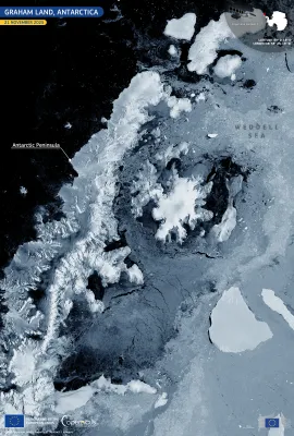
Graham Land, the northernmost stretch of the Antarctic Peninsula, is one of the most rapidly warming regions on Earth. Its mountainous spine and outlet glaciers drain into the Weddell Sea, forming an important transition zone between grounded ice, floating shelves, and open water. This dynamic landscape supports rich marine ecosystems,...
Results (1173)
Shark Bay, located on the western coast of Australia, is a UNESCO World Heritage Site renowned for its exceptional natural beauty, including unique marine biodiversity and one of the world's most extensive seagrass beds. The site is globally significant for its ecological processes, geological formations, and as a habitat for threatened species...
The Gulf of Morbihan, part of the Natura 2000 network, forms one of France’s most distinctive coastal landscapes. This inland sea is dotted with dozens of small islands and peninsulas, creating a labyrinth of sheltered bays, narrow channels, and shifting tidal flats. Its highly indented shape supports a mosaic of coastal habitats, from eelgrass...
Early winter in north-western Africa is marked by the arrival of Atlantic weather systems that bring cooler air, increased cloud cover, and the first significant precipitation of the season. As these systems interact with the region’s varied terrain, they frequently produce episodes of heavy rain in lowland areas and snowfall across the...
The United Nations’ World Urbanisation Prospects 2025 was published on 17 November 2025. Drawing on data from the Joint Research Centre’s Global Human Settlement Layer (GHSL), developed under the Copernicus Emergency Management Service (CEMS), the report tracks changes in population distribution across more than 12,000 urban settlements. It...
Torrential rainfall associated with Cyclone Ditwah, which made landfall on Sri Lanka’s eastern coast on 28 November 2025, resulted in extensive flooding across the country. The event caused at least 410 casualties, with 336 people reported missing. The Copernicus Emergency Management Service (CEMS) was activated (EMSR851) to assess the extent...
Cyclone Senyar formed during the night of 25-26 November 2025 in the Strait of Malacca, an area in which tropical cyclones had not been recorded for decades. The day after its formation, Senyar hit Indonesia, where it made landfall, causing flooding, landslides and more than 400 casualties in the north of the island of Sumatra. This image,...
On 17 October 2025, one of the Copernicus Sentinel-2 satellites acquired this image of Cluj-Napoca, a major urban centre in north-western Romania. Surrounded by rolling hills and agricultural land, the city is noted for its dynamic growth and strategic role in regional development. Cluj-Napoca also received the label of the EU Mission for...
The Bolivian Altiplano, part of the vast Andean plateau, is among the highest inhabited regions on Earth. This arid landscape is characterised by deep canyons, colourful sedimentary formations, and rugged ridgelines shaped over millennia by wind and water erosion. This false-colour image, acquired on 1 January 2025 by one of the Copernicus...
On 16 November 2025, one of the Copernicus Sentinel-2 satellites acquired this image of the Huelva estuary in south-western Spain, where the Tinto and Odiel rivers converge before flowing into the Atlantic Ocean. Recent rainfall has increased surface runoff and sediment transport, strengthening the contrasting outflow from the two rivers. The...
On 23 November 2025, the Hayli Gubbi volcano in north-eastern Ethiopia erupted for the first time in recorded history. The volcano is located in the seismically active Afar Depression, part of the African Rift fault system. The event generated an ash and gas column reaching approximately 13–15 km, and the ash cloud spread over the Red Sea...
On 18 November 2025, the first major winter weather event of the 2025-26 season took place across parts of the United Kingdom, including north-east Scotland. Heavy snowfall blanketed large areas of the region, leading to travel disruption, the isolation of several rural communities, and the closure of numerous schools. Emergency services were...
Following its launch on 4 November 2025, Copernicus Sentinel-1D has delivered its first images. Among these is this radar image acquired on 7 November 2025, showing northern Germany. The false colour visualisation of the image highlights different types of land cover such as cultivated fields, water bodies, and urban areas, including the cities...
Copernicus Sentinel-5A has delivered its first images after its launch on 13 August 2025, marking a significant milestone in the monitoring of air quality from space. The Sentinel-5 mission provides observations of key air pollutants, essential climate variables, and stratospheric ozone, which is the protective layer shielding life on Earth...
On 23 November 2025, the Hayli Gubbi volcano in Ethiopia, located approximately 800 kilometres north-east of Addis Ababa, erupted for the first time in nearly 12,000 years. As a result of the eruption, a large sulfur dioxide (SO₂) plume was emitted into the atmosphere. This image, derived from data acquired by the Copernicus Sentinel-5P...
Every autumn, as temperatures fall and daylight hours shorten across Japan, the country enters its annual kōyō season, when the combination of reduced sunlight and cooler temperatures triggers the transition of tree leaves from green to autumnal reds and browns. This Copernicus Sentinel-2 image from 17 November 2025 shows widespread autumn...
As winter approaches in the Northern Hemisphere, reduced sunlight at high latitudes leads to colder temperatures and the formation of sea ice along the eastern coast of Greenland. This Copernicus Sentinel-2 image, acquired on 13 November 2025, shows the region illuminated in the soft light of a low sun, which creates elongated shadows across...
On 8 November 2025, a wildfire swept through nearly 3,000 hectares of alpine ecosystem in the Tongariro National Park, New Zealand. The fire damaged important habitats for native species on the North Island. Teams from the Department of Conservation, with support from Fire and Emergency New Zealand, fully contained the fire, and restoration...
On 18 November 2025, intense flooding and a devastating landslide struck the Friuli Venezia Giulia region in northern Italy following prolonged, intense rainfall. The area surrounding the towns of Gorizia and Romans d’Isonzo were affected by significant inundation, with rivers overtopping their banks and submerging adjacent lowlands. This...
On 14 November 2025, Storm Claudia swept across Ireland, bringing severe weather conditions and significant flooding to the Leinster and Munster provinces. The Copernicus Emergency Management Service (CEMS) was activated (EMSR849) to assess the extent and impact of flooding in the affected regions. This data visualisation, obtained using the...
Showing 181-200 of 1173 results