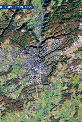
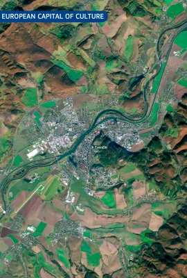
European Union flag
EU Space Policy

Explore EU Space

Results (1080)
Image of the Day
The Tatra Mountains, Poland and Slovakia
Earth Observation | Copernicus
The Tatra Mountains, visible in this Copernicus Sentinel-2 image, acquired on 20 October 2025, form a natural border between southern Poland and northern Slovakia, are among Central Europe’s most picturesque mountainous landscapes. The region typically receives its first snowfall in late October, whereas the surrounding areas remain snow-free...
Image of the Day
Dust over the Arabian Sea
Earth Observation | Copernicus
A large plume of dust swept across the Arabian Sea in early November 2025, driven by strong north-westerly winds transporting fine particles from the arid regions of Iran and southern Pakistan.  Dust storms are common in this region, in which vast dry basins and persistent winds create favourable conditions for the uplift and long-range...
Image of the Day
Devastating flooding in Vietnam
Earth Observation | Copernicus
In late October 2025, severe flooding struck Vietnam after days of intense rainfall. Thousands of residents evacuated their homes, with local authorities reporting at least 37 casualties. The province of Quảng Nam has been particularly affected by the impacts of the flooding. In this image, acquired by one of the Copernicus Sentinel-1...
Image of the Day
Coastal ecosystems in northern Egypt
Earth Observation | Copernicus
At the northeastern edge of Egypt’s Nile Delta, the Damietta branch of the Nile flows towards the Mediterranean Sea, crossing a region of significant ecological and economic importance. This area encompasses fertile agricultural land, expanding urban centres, and sensitive coastal and wetland ecosystems. This image, acquired by the Copernicus...
Image of the Day
Copernicus Sentinel-1D: a new EU satellite in orbit
Earth Observation | Copernicus
Copernicus Sentinel-1D was successfully launched on 4 November 2025 at 22:02 CET (21:02 UTC) aboard an Ariane 6 rocket from the European Spaceport in Kourou, French Guiana. The satellite was released into orbit 34 minutes after launch, and the first signal was received at 23:22 CET by the Troll ground station in Antarctica. At the heart of...
Image of the Day
The impacts from Hurricane Melissa monitored by Copernicus EMS
Earth Observation | Copernicus
Hurricane Melissa formed over the central Caribbean Sea on 22 October 2025 before moving north-west and making landfall in Jamaica as a Category 5 hurricane, the most powerful ever recorded on the island. As it continued across the Jamaica Channel, it struck the eastern coast of Cuba with sustained intensity (Category 3) before weakening over...
Image of the Day
Earth Observation | Copernicus
On 25 October 2025, the Planchón-Peteroa volcanic complex, located on the Chile–Argentina border, emitted a sustained plume of volcanic gas and fine ash that rose to approximately 600 m above the crater. The plume initially drifted north-north-west; however, shifting wind conditions during the day redirected the ash eastwards, carrying it over...
Image of the Day
Inland Delta of the Niger River, Mali
Earth Observation | Copernicus
The Inland Delta of the Niger River, classified as a Ramsar wetland of international importance in 2004, supports agriculture and biodiversity in Mali.  At the northern edge of the delta in Mali, near the Sahara Desert, persistent wind patterns have shaped long, parallel sand dune ridges. These elevated dunes remain exposed even during peak...
Image of the Day
The southern tip of South America as seen from space
Earth Observation | Copernicus
This image, acquired by one of the Copernicus Sentinel-3 satellites on 27 October 2025, provides a rare, cloudless view of the southernmost regions of South America, including parts of Argentina and Chile.  The image shows the snow-capped Andes stretching along the western edge of the continent, contrasting sharply with the arid Patagonian...
Image of the Day
Mapping Dublin’s Urban Fabric on World Cities Day
Earth Observation | Copernicus
On World Cities Day, 31 October 2025, we spotlight Dublin, Ireland’s capital and a hub of cultural, economic, and social activity. Rapid urban expansion in some European cities such as Dublin brings mounting pressures on infrastructure, housing, mobility, and the environment. Managing these dynamics requires precise and up-to-date spatial...
Image of the Day
Copernicus Sentinel-6: measuring sea levels from space
Earth Observation | Copernicus
The Copernicus Sentinel-6 satellite mission is the global reference for measuring sea surface height. The first satellite of the mission, Copernicus Sentinel-6 Michael Freilich (Sentinel-6A), was launched in 2020. It follows a well-established, 10-day repeat orbit, delivering sea-level measurements with centimetre-level accuracy. Data from...
Image of the Day
20251029_Eye Hurricane Melissa
Earth Observation | Copernicus
On 28 October 2025, Hurricane Melissa, the most powerful storm to hit Jamaica in history, made landfall on the island with devastating force. With sustained winds reaching 298 km/h and a central pressure of 892 hPa, Melissa already ranks among the most intense hurricanes ever observed in the Atlantic basin.
Image of the Day
Sentinel-2 captures a vivid view of hurricane Melissa's eye
Earth Observation | Copernicus
On 28 October 2025, Hurricane Melissa, the most powerful storm to hit Jamaica in history, made landfall on the island with devastating force. With sustained winds reaching 298 km/h and a central pressure of 892 hPa, Melissa already ranks among the most intense hurricanes ever observed in the Atlantic basin. On that day, at 15:55 UTC, one of the...
Image of the Day
Mont Idoukal-n-Taghès, Niger
Earth Observation | Copernicus
Rising to 2,022 metres, Mont Idoukal-n-Taghès is the highest peak in Niger and a prominent feature of the Aïr Massif in the north of the country. This mountainous region of volcanic origin stands out as a biodiversity hotspot within the arid expanse of the southern Sahara. This natural-colour image, acquired on 8 September 2025 by one of the...
Image of the Day
Hurricane Melissa
Earth Observation | Copernicus
After forming in the central Atlantic Ocean at the end of October 2025, Hurricane Melissa underwent rapid intensification as it moved westward across the Atlantic, reaching Category 4 status with sustained winds of 225 km/h. The storm then began to move west-north-west, passing through the Greater Antilles and severely affecting the Dominican...
Image of the Day
Sediments along the coast of eastern Iceland
Earth Observation | Copernicus
With a length of around 150 km, the Jökulsá á Dal is among Iceland’s longest rivers. It carries meltwater and sediments from Vatnajökull, Europe’s largest glacier, across the eastern highlands. The Jökulsá á Dal river flows into Lagarfljót Lake, a long and narrow waterbody uniquely classified as both a river and a lake, before reaching the...
Image of the Day
Devastating landslides and flooding in Chapula, Mexico
Earth Observation | Copernicus
In October 2025, large parts of central and eastern Mexico have faced severe flooding, triggered by torrential rainfall from converging tropical storms. According to local authorities, there have been at least 64 reported casualties, with dozens of people missing. The village of Chapula has been particularly impacted by landslides and flooding...
Image of the Day
Geneva from Above: Celebrating 80 Years of the United Nations
Earth Observation | Copernicus
24 October 2025 is United Nations Day, marking 80 years since the United Nations Charter came into force. As the cornerstone of international cooperation, the United Nations plays a vital role in promoting peace, protecting human rights, and advancing global sustainable development.  This striking true-colour image acquired by one of the...
Image of the Day
Floods on Panay Island, the Philippines
Earth Observation | Copernicus
Extensive flooding swept across Panay Island in the Philippines following heavy rains from Tropical Storm Ramil on 18 October 2025. The storm brought record-breaking rainfall, with Roxas City receiving up to 365.5 mm in just 24 hours – more than a month's worth of precipitation in a single day. According to local authorities, over...
Image of the Day
The unique floating islands of Loktak Lake, India
Earth Observation | Copernicus
Loktak Lake, located in the state of Manipur, is the largest freshwater lake in north-eastern India, renowned for its floating islands known as phumdis: masses of vegetation, soil, and organic matter which support both human settlements and diverse ecosystems. The lake plays a crucial role in the local economy by supporting fishing,...

Showing 141-160 of 1080 results