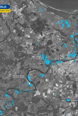
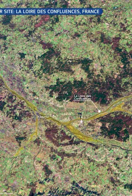
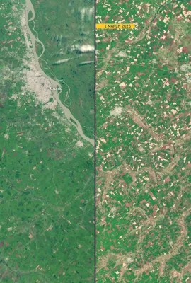
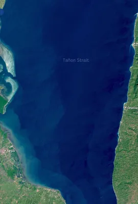
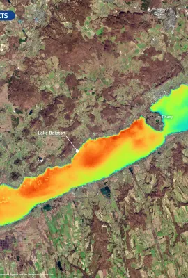
European Union flag
EU Space Policy

Explore EU Space

Results (1080)
Image of the Day
The new morphology of the Hayli Gubbi volcano
Earth Observation | Copernicus
On 23 November 2025, the Hayli Gubbi volcano in north-eastern Ethiopia erupted for the first time in recorded history. The volcano is located in the seismically active Afar Depression, part of the African Rift fault system. The event generated an ash and gas column reaching approximately 13–15 km, and the ash cloud spread over the Red Sea...
Image of the Day
Snow blanketed North East Scotland
Earth Observation | Copernicus
On 18 November 2025, the first major winter weather event of the 2025-26 season took place across parts of the United Kingdom, including north-east Scotland. Heavy snowfall blanketed large areas of the region, leading to travel disruption, the isolation of several rural communities, and the closure of numerous schools. Emergency services were...
Image of the Day
First images acquired by Sentinel-1D
Earth Observation | Copernicus
Following its launch on 4 November 2025, Copernicus Sentinel-1D has delivered its first images. Among these is this radar image acquired on 7 November 2025, showing northern Germany. The false colour visualisation of the image highlights different types of land cover such as cultivated fields, water bodies, and urban areas, including the cities...
Image of the Day
First images from Copernicus Sentinel-5A
Earth Observation | Copernicus
Copernicus Sentinel-5A has delivered its first images after its launch on 13 August 2025, marking a significant milestone in the monitoring of air quality from space. The Sentinel-5 mission provides observations of key air pollutants, essential climate variables, and stratospheric ozone, which is the protective layer shielding life on Earth...
Image of the Day
Eruption of Hayli Gubbi volcano, Ethiopia
Earth Observation | Copernicus
On 23 November 2025, the Hayli Gubbi volcano in Ethiopia, located approximately 800 kilometres north-east of Addis Ababa, erupted for the first time in nearly 12,000 years.  As a result of the eruption, a large sulfur dioxide (SO₂) plume was emitted into the atmosphere. This image, derived from data acquired by the Copernicus Sentinel-5P...
Image of the Day
Autumn colours across Honshu Island, Japan
Earth Observation | Copernicus
Every autumn, as temperatures fall and daylight hours shorten across Japan, the country enters its annual kōyō season, when the combination of reduced sunlight and cooler temperatures triggers the transition of tree leaves from green to autumnal reds and browns.  This Copernicus Sentinel-2 image from 17 November 2025 shows widespread autumn...
Image of the Day
Eastern Greenland at the start of winter
Earth Observation | Copernicus
As winter approaches in the Northern Hemisphere, reduced sunlight at high latitudes leads to colder temperatures and the formation of sea ice along the eastern coast of Greenland. This Copernicus Sentinel-2 image, acquired on 13 November 2025, shows the region illuminated in the soft light of a low sun, which creates elongated shadows across...
Image of the Day
Wildfire in the Tongariro National Park, New Zealand
Earth Observation | Copernicus
On 8 November 2025, a wildfire swept through nearly 3,000 hectares of alpine ecosystem in the Tongariro National Park, New Zealand. The fire damaged important habitats for native species on the North Island. Teams from the Department of Conservation, with support from Fire and Emergency New Zealand, fully contained the fire, and restoration...
Image of the Day
Floods in northern Italy
Earth Observation | Copernicus
On 18 November 2025, intense flooding and a devastating landslide struck the Friuli Venezia Giulia region in northern Italy following prolonged, intense rainfall. The area surrounding the towns of Gorizia and Romans d’Isonzo were affected by significant inundation, with rivers overtopping their banks and submerging adjacent lowlands.   This...
Image of the Day
Flooding in Ireland after Storm Claudia
Earth Observation | Copernicus
On 14 November 2025, Storm Claudia swept across Ireland, bringing severe weather conditions and significant flooding to the Leinster and Munster provinces. The Copernicus Emergency Management Service (CEMS) was activated (EMSR849) to assess the extent and impact of flooding in the affected regions.  This data visualisation, obtained using the...
Image of the Day
Offshore wind farms in the North Sea
Earth Observation | Copernicus
The acceleration of the clean energy transition across Europe offshore wind farms has made offshore wind farms essential for reducing greenhouse gas emissions and ensuring a more sustainable future.  In this Copernicus Sentinel-1 radar image, acquired on 15 October 2025, clusters of wind turbines appear as bright, structured formations on the...
Image of the Day
Dust over Sardinia, Italy and Corsica, France
Earth Observation | Copernicus
On 14 November, a dust storm originating in North Africa swept across the western Mediterranean.  This Copernicus Sentinel-3 image, acquired on 15 November, clearly shows the phenomenon: a thick layer of Saharan dust stretches northwards, partially obscuring the islands of Sardinia (to the south and Corsica to the north). The reddish tones over...
Image of the Day
Successful launch of Copernicus Sentinel-6B
Earth Observation | Copernicus
Copernicus Sentinel-6B was successfully launched earlier this morning at 06:21 CET from Vandenberg Base in California. The satellite sent its first signal down to Earth at 07:54, confirming that it is healthy. This radar altimetry satellite, developed through a partnership between the European Commission, the European Space Agency (ESA), the...
Image of the Day
The Ganges River, India
Earth Observation | Copernicus
This image, acquired one of the Copernicus Sentinel-2 satellites on 25 October 2025, shows a meandering stretch of the Ganges River in eastern India. Flowing through the district of Sahibganj in the state of Jharkhand, the river exhibits a dynamic braided pattern, shaped by intense seasonal flows and sediment transport. The surrounding...
Image of the Day
Gothenburg, Sweden
Earth Observation | Copernicus
On 18 October 2025, one of the Copernicus Sentinel-2 satellites acquired this image of Gothenburg, Sweden’s second largest city. Gothenburg is located on the country’s western coast along the Kattegat, the strait between Denmark and Sweden which forms part of the maritime link between the North Sea and the Baltic Sea. Gothenburg is among the...
Image of the Day
Disastrous flooding in the Philippines
Earth Observation | Copernicus
Following the landfall of Typhoon Fung-wong on 9 November 2025, northern regions of the Philippines were affected by extensive flooding, with the Cagayan Valley among the worst hit areas. The typhoon brought intense rainfall, causing the Cagayan River to overflow its banks, submerging agricultural land, infrastructure, and urban areas,...
Image of the Day
The volcanic Nisyros Island, Greece, designated a UNESCO Global Geopark
Earth Observation | Copernicus
In October 2025, the volcanic island of Nisyros, in the south-eastern Aegean Sea, was recognised as the tenth Greek site to join the UNESCO Global Geoparks Network, reflecting its geological and environmental value. Nisyros is a dormant volcano within one of the most tectonically active zones of the eastern Mediterranean, shaped by past...
Image of the Day
First snowfall of the season over the Pyrenees
Earth Observation | Copernicus
The Pyrenees are an important ecological corridor stretching between France and Spain, connecting Atlantic and Mediterranean ecosystems across a rugged mountain landscape. The mountain range supports high-altitude grasslands, ancient forests, and glacial valleys, providing habitat for endemic species.  The arrival of snow marks the beginning of...
Image of the Day
October 2025, the third warmest October on record
Earth Observation | Copernicus
The Copernicus Climate Change Service (C3S) has published its latest monthly Climate Bulletin, which focuses on key climate trends in October 2025. The bulletin reports that October 2025 was the third-warmest October globally, with an average surface air temperature of 15.14°C, 0.70°C above the 1991-2020 average for the month.  This data...
Image of the Day
Belém hosts COP30
Earth Observation | Copernicus
Belém, the capital of the state of Pará in northern Brazil, lies near the mouth of the Amazon River and has grown into a key economic and logistical centre for the wider Amazon region. Located within the tropical rainforest zone, the city is the site of both urban expansion and important ecosystems. This false-colour image, acquired by one of...

Showing 121-140 of 1080 results